Province No. 1
Province No. 1
प्रदेश नं० १ | |
|---|---|
Province No. 1 | |
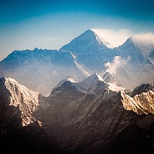
  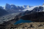     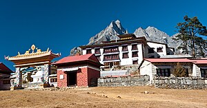 From top left to right Mount Everest, Kanchenjunga, Gokyo Lakes, Namche Bazaar, Barun Valley, Ilam, Halesi Mahadev Temple and Tengboche Monastery all located in Province No. 1 of Nepal | |
 Location of Province No. 1 in Nepal | |

Khotang
Solu
khumbu Sankhuwa
sabha Taplejung
Okhal
dhunga Udayapur
Bhojpur
Tehra
thum Panch
thar Ilam
Jhapa
Morang
Sunsari
Dhankuta
PN-2
China
India
Province No. 1 | |
| Coordinates: 26°27′15″N 87°16′47″E / 26.45417°N 87.27972°ECoordinates: 26°27′15″N 87°16′47″E / 26.45417°N 87.27972°E | |
| Country | |
| Formation | 20 September 2015 |
| Capital city | Biratnagar[1] |
| Largest city | Biratnagar |
| Districts | 14 |
| Government | |
| • Type | Self-governing Province |
| • Body | Government of Province No.1 |
| • Governor | Somnath Adhikari Pyasi |
| • Chief Minister | Sher Dhan Rai (UML) |
| • High Court | Biratnagar High Court |
| • Provincial Assembly | Unicameral (93 seats) |
| • Parliamentary constituency | 28 |
| Area | |
| • Total | 25,905 km2 (10,002 sq mi) |
| Area rank | 2nd |
| Highest elevation | 8,848 m (29,029 ft) |
| Lowest elevation | 70 m (230 ft) |
| Population (2011) | |
| • Total | 4,534,943 |
| • Rank | 3rd |
| • Density | 180/km2 (450/sq mi) |
| • Density rank | 4th |
| • Households | 991,750 |
| Demographics | |
| • Ethnic groups | Hindus, Kirat, Buddhist |
| • Ethnic castes | Rai, Limbu, Chettri, Bahun, Sherpa |
| • Sex ratio | 91.48 ♂ /100 ♀ (2011) |
| Human Development Index 0.553 | |
| • Poverty rate | 0.127[4] |
| • Literacy | 65.30% |
| • Life Expectancy | 69% |
| Time zone | UTC+5:45 (NPT) |
| Geocode | NP-ON |
| Official language | Nepali (43.07%) |
| Other language(s) | 1. Maithili 2. Limbu |
| Website | p1 |

Province No. 1 (proposed names: Kirat/Kirat Limbuwan/Sagarmatha/Koshi)[6] is the easternmost of the seven provinces established by the new constitution of Nepal which was adopted on 20 September 2015.[6] The province covers an area of 25,905 km2, about 17.5% of the country's total area. With the industrial city of Biratnagar as its headquarter, the province covers other major eastern towns including Damak, Dharan, Itahari, Inaruwa and Birtamod and includes several mountains including the Everest, Kanchenjunga, and Ama Dablam. Koshi – the largest river of the nation, circumvents the province's western boundary. Adhering to the first-past-the-post voting system issued by the Constituency Delimitation Commission, the province hosts 28 parliamentary seats and 56 provincial seats.[7]
The province is bordered by the Tibet Autonomous Region of China to the north, the Indian states of Sikkim and West Bengal to the east, and Bihar to the south, and Bagmati Province and Province No. 2 to the west.[8][9][10] According to the 2011 census, there are around 4.5 million people in the province, with a population density of 175.6 per square kilometer.[11]
History[]

At the end of Rana regime, Nepal was divided into 32 districts. Eastern Nepal (Province No. 1) contained following districts:
- Morang District (Jhapa, Sunsari & Morang)
- Udayapur District
- Ilam District
- Dhankuta District (Taplejung, Panchthar, Terhathum, Sankhuwasabha, Dhankuta)
- Bhojpur District (east no. 4) (Bhojpur, Khotang)
- Okhaldhunga District (east no. 3) (Okhaldhunga and Solukhumbu)
In 1956, eastern districts of Nepal grouped in a region named "Arun Kshetra". Arun Kshetra was composed by grouping the then 5 districts. Those 5 districts are now divided into many districts. Arun Kshetra had total area of 7,000 square miles (18,000 km2) and total population was 11 Lakhs.[12] The five districts were:
- Biratnagar District (Sunsari, Morang)
- Dhankuta District (Dhankuta, Sankhuwasabha)
- Taplejung District (Taplejung, Panchtharl)
- Mechi District (Ilam, Jhapa)
- Bhojpur District (Bhojpur, Khotang)
In 1962, administrative system restructured and the "Kshetras" system cancelled and the country restructured into 75 development districts and those districts were grouped into zones.[13] In 1972 area of the Province No. 1 named Eastern Development Region. It had 3 zones and 16 districts.
As per the cabinet meeting held on 17 January 2018, the city of Biratnagar was declared the interim capital of Province No. 1. It was later declared as the permanent capital on 6 May 2019 when two-thirds of the provincial assembly's MLAs voted in favor of Biratnagar.[1]
Geography[]

Province No. 1 covers an area of 25,905 km2.[11] The province has three-fold geographical division: Himalayan in the north, Hilly in the middle and Terai in the southern part of Nepal, varying between an altitude of 70 m and 8,848 m. Terai, extended from east to west, is made up of alluvial soil. To the west of Koshi River, in between Mahabharat Range and Churia Range, there elongates a valley called Inner Terai. Churai Range, Mahabharat Range and other hills of various height, basins, tars and valleys form the hilly region. Some parts of this region are favorable for agriculture but some other parts are not. Himalayan region, in the north, consists of many mountains ranges. Mahalangur, Kumbhakarna, Umvek, Lumba Sumba and Janak being some of them. The highest mountain in the world, Mount Everest (8848.86 m); and the third highest mountain, Kangchenjunga (8598 m) also lie in this province.
Nepal's lowest point, Kechana Kawal at 70 m, is located in Jhapa district of this province. There are many river basins and gentle slopes as well. Chure, Mahabharat, many basins, tars and valleys form the Terai region. Between the Churia and Mahabharat a low land of inner Terai exists. The Koshi river flows through the region with its seven tributaries; Indrawati, Likhu, Tamur, Dudh Kosi, Arun, Tamakoshi and Bhote Koshi (Sunkoshi). Tundra vegetables, coniferous forest, deciduous monsoon forests and sub-tropical evergreen woods are vegetations found here. Sub-tropical, temperate, sub-temperate, and alpine and tundra types of climates are found here.
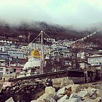
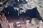
Province No. 1 also includes the snow fall capped peaks including Mount Everest, Kangchenjunga, Makalu with Solukhumbu, Sankhuwasabha, and Taplejung districts towards the north, the jungle clad hill tracts of Okhaldhunga, Khotang, Bhojpur, Tehrathum, Ilam and Panchthar in the middle and the alluvial fertile plains of Udayapur, Sunsari, Morang and Jhapa. Province No. 1 includes places like Haleshi Mahadev Temple, Pathivara Temple and Barahachhetra, which are the famous religious shrines for Hindus.
Climate[]
Climatic conditions of Nepal vary from one place to another in accordance with their geographical features. Province No. 1 has three geographical folds: the low-land of Terai, the hilly region and the highlands of the Himalayas. The low land altitude is 59 m, whereas the highest point is 8848 m.
In the north, summers are cool and winters severe, while in the south, summers are tropical and winters are mild. Climatically, the southern belt of the province, the Terai, experiences a warm and humid climate. Eastern Nepal receives approximately 2,500 millimeters of rain annually. Province No. 1 has five seasons: spring, summer, monsoon, autumn and winter.
| Location | August
(°F) |
August
(°C) |
January
(°F) |
January
(°C) |
Annual
Precipitation (mm/in) |
|---|---|---|---|---|---|
| Damak | 94 / 82 | 34 / 28 | 74 / 47 | 23 / 8 | 2618 /103.07 |
| Dharan | 85.1/72.3 | 29.5/22.4 | 68.4/44.4 | 20.2/6.9 | 1416/55.7 |
| Biratnagar | 83.1 | 28.4 | 60.8 | 16 | 1549.8/61 |
| Bhadrapur | 82.2 | 27.9 | 61.2 | 16.2 | 2351.9/92.6 |
| Dhankuta | 76.5 | 24.7 | 54.5 | 12.5 | 1809.5/71.2 |
| Khandbari | 74.8 | 23.8 | 52 | 11.1 | 2040.7/80.3 |
| Ilam | 71.8 | 22.1 | 50.9 | 10.5 | 2551.5/100.5 |
| Bhojpur | 69.1 | 20.6 | 46.8 | 8.2 | 2290.4/90.2 |
| Khumbu Pasang Lhamu | 56.1/38.3 | 13.4/3.5 | 33.8/-0.8 | 1/-18.2 | 645/25.4 |
Mountains[]

Northern part of Province No. 1 has the highest mountain of the world. Here is a list of mountains in Province No. 1.
| Mountain/peak | metres | feet | Section | Notes |
|---|---|---|---|---|
| Mount Everest | 8,848.86 | 29,032 | Khumbu Mahalangur | Earth's highest peak from sea level |
| Kanchenjunga | 8,586 | 28,169 | Northern Kangchenjunga | 3rd highest on Earth |
| Lhotse | 8,516 | 27,940 | Everest Group | 4th highest |
| Makalu | 8,463 | 27,766 | Makalu Mahalangur | 5th highest |
| Cho Oyu | 8,201 | 26,906 | Khumbu Mahalangur | 6th highest |
| Gyachung Kang | 7,952 | 26,089 | Khumbu Mahalangur | between Everest and Cho Oyu |
| Nuptse | 7,861 | 25,791 | Everest Group | 319 metres prominence from Lhotse |
| Jannu | 7,711 | 25,299 | Kumbhakarna Kangchenjunga | |
| Kabru | 7,412 | 24,318 | Singalila Kangchenjunga | |
| Kirat Chuli | 7,365 | 24,163 | Kangchenjunga | |
| Nangpai Gosum | 7,350 | 24,114 | Khumbu Mahalangur | |
| Chamlang | 7,321 | 24,019 | Barun Mahalangur | #79 in the world |
| Pumori | 7,161 | 23,494 | Khumbu Mahalangur | First ascent 1962 |
| Baruntse | 7,129 | 23,389 | Barun Mahalangur | First ascent 1954 |
| Ama Dablam | 6,812 | 22,349 | Barun Mahalangur | "Mother and her necklace" |
| Kangtega | 6,782 | 22,251 | Barun Mahalangur | First ascent 1963 |
| Cho Polu | 6,735 | 22,096 | Barun Mahalangur | First ascent 1999 |
| Lingtren | 6,714 | 22,028 | Khumbu Mahalangur | First ascent 1935 |
| Num Ri | 6,677 | 21,906 | Barun Mahalangur | First ascent 2002 |
| Khumbutse | 6,640 | 21,785 | Khumbu Mahalangur | First mountain west of Everest |
| Thamserku | 6,623 | 21,729 | Barun Mahalangur | First ascent 1964 |
| Pangboche | 6,620 | 21,719 | Kutang Himal | |
| Taboche | 6,542 | 21,463 | Khumbu Mahalangur | First ascent 1974 |
| Mera Peak | 6,476 | 21,247 | Himalayas | Trekking peak |
| Cholatse | 6,440 | 21,129 | Khumbu Mahalangur | Connected to Taboche |
| Kusum Kangguru | 6,367 | 20,889 | Barun Mahalangur | Trekking peak (difficult) |
| Ombigaichan | 6,340 | 20,801 | Barun Mahalangur | |
| Kongde Ri | 6,187 | 20,299 | Barun Mahalangur | Trekking peak (difficult) |
| Imja Tse | 6,160 | 20,210 | Khumbu Mahalangur | Also known as Island Peak. Popular trekking peak. |
| Lobuche | 6,145 | 20,161 | Khumbu Mahalangur | Trekking peak |
| Nirekha | 6,069 | 19,911 | Khumbu Mahalangur | Trekking peak (difficult) |
| Pokalde | 5,806 | 19,049 | Khumbu Mahalangur | Trekking peak (moderate) |
| Mount Khumbila | 5,761 | 18,901 | Mahalangur | Unclimbed |
| Kala Patthar | 5,545 | 18,192 | Khumbu Mah | Popular hiking peak below Pumori |
| Gokyo Ri | 5,357 | 17,575 | Himalayas | Popular hiking peak |

Rivers[]
There are many rivers in the region which flow towards south from the Himalayas which are tributaries of other large rivers which joins Ganga River (in India). Sapta Koshi or the Koshi is the main river of the region. Seven tributaries join the Koshi so it called Saptkoshi.
The major rivers in the province are:
- Mechi River
- Kankai River
- Koshi River (SaptaKoshi) Below given names are tributaries:
- Tamor
- Arun River
- Sun Koshi
- Dudh Koshi
- Likhu Khola
- Tama Koshi
- Indrawati River
Protected Areas[]
- Sagarmatha National Park – 1,148 km2 (443 sq mi) (National Park)
- Makalu Barun National Park – 1,500 km2 (580 sq mi) (National Park)
- Koshi Tappu Wildlife Reserve – 175 km2 (68 sq mi) (Wildlife reserves)
- Kanchenjunga Conservation Area – 2,035 km2 (786 sq mi) (Conservation areas)
- Gokyo Lake Complex – 7,770 ha (30.0 sq mi) (Ramsar Sites)
- Koshi Tappu Wildlife Reserve – 17,500 ha (68 sq mi) (Ramsar Sites)
- Mai Pokhari – 90 ha (220 acres) (Ramsar Sites)
Subdivisions[]
There are total 137 local administrative units in this province, in which there is 1 metropolitan city, 2 sub-metropolitan cities, 46 municipalities and 88 rural municipalities.
Districts[]
The province is made up of the 14 following districts:
|
|
|
|
Municipality[]

Cities and villages are governed by municipalities in Nepal. A district may have one or more municipalities. Province No. 1 has two types of municipalities.
- Urban Municipality (Urban Municipality has three levels):
- Metropolitan city
- Sub-metropolitan city and
- Municipality
- Rural Municipality (Gaunpalika)
The government of Nepal has set out a minimum criteria to meet city and towns. These criteria include a certain population, infrastructure and revenues.
Administration[]
The first provincial assembly elections in Nepal were held on 26 November and 7 December 2017.
After the results of the recent election in Province No. 1 the biggest party is CPN (UML) which wins 51 seats out of 93 seats and second biggest party is Nepali Congress which wins 21 seats and third biggest party is CPN (Maoist Center) which wins 15 seats in first Provincial Assembly election.[15]
There are 56 FPTP and 37 PR seats in the province.
In a meeting on 17 January 2018 government of Nepal finalized the temporary capital of Province No. 1, the meeting also appointed Govinda Subba as the .[16]
Sher Dhan Rai was elected as Chief Minister of Province No. 1 on February 14, 2018.[17] He was a former Minister for Information and Communications. He was appointed as the chief minister, according to Article 168 (1) of the Constitution of Nepal.[17]
Provincial Assembly[]
The first meeting of the provincial assembly was held on 5 February 2018 in Biratnagar and was chaired by Om Prakash Sarbagi.[18] Pradeep Kumar Bhandari was elected unopposed as the Speaker of the Provincial Assembly on 11 February 2018.[19] Saraswoti Pokharel was also elected unopposed to the post of Deputy Speaker on 15 February 2018.[20]
 | ||||
| Party | FPTP | PR | Total | |
|---|---|---|---|---|
| NCP | 46 | 20 | 66 | |
| Nepali Congress | 8 | 13 | 21 | |
| Federal Socialist Forum, Nepal | 1 | 2 | 3 | |
| Rastriya Prajatantra Party | 0 | 1 | 1 | |
| Sanghiya Loktantrik Rastriya Manch | 0 | 1 | 1 | |
| Independent | 1 | - | 1 | |
| Total | 56 | 37 | 93 | |
| Source: Election Commission of Nepal | ||||
Transportation[]
All provinces of Nepal except Province No. 2 have difficult geographic features. Only three districts out of fourteen of Province No. 1 falls in Terai and one district falls in inner Terai. Elevation from lowest point of Nepal, Kechana (70 m above sea level) to the highest point of world, Everest (8848 m above sea level) lies in this province, so maintaining consistent road network is one of the most challenging. Despite of those challenges, all districts are connected via road networks. Air services are available. Rail services are under construction.
Roadways[]
Almost all districts are connected by roads in Province No. 1, although some roads at high altitudes are not paved and conditions of those roads worsen during the rainy season. In the hills and mountain regions, the traffic is much lighter compared to Terai regions like Jhapa and Morang due to difficult terrain.
The main highways of Province No. 1 connect Terai to the high altitude regions. There are feeder roads too for inter-district and in-district travel.
- Mechi Highway: 268 km long two-lane freeway which connects Jhapa to Taplejung. The main destinations along the highway include Prithivinagar, Bhadrapur, Duhagadhi, Budhabare, Kanyam, and Phikkal.
- Koshi Highway: 159 km long two-lane road which starts in Biratnagar and connects to Myanglung. Itahari, Dharan, Dhankuta, Bhedetar, Hile etc. are the destinations along the highway.
- Sagarmatha Highway: 265 km long two lane highway which starts from Kadmaha of Province No. 2 and connects with Solukhumbu. Gaighat, Saune etc. are the destinations along with highway.
- Mahendra Highway is the major east-west highway of Nepal. It starts in Kakarbhitta in Province No. 1.
Airways[]
| Forbesganj-Biratnagar | ||||||||||||||||||||||||||||||||||||||||||||||||||||||||||||||||
|---|---|---|---|---|---|---|---|---|---|---|---|---|---|---|---|---|---|---|---|---|---|---|---|---|---|---|---|---|---|---|---|---|---|---|---|---|---|---|---|---|---|---|---|---|---|---|---|---|---|---|---|---|---|---|---|---|---|---|---|---|---|---|---|---|
| ||||||||||||||||||||||||||||||||||||||||||||||||||||||||||||||||
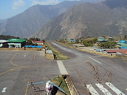
Many domestic airports and air services are available in the region including one of the most geographically challenging airports, Lukla Airport.
Airports in Province No. 1:
- Bhojpur Airport (Bhojpur)
- Biratnagar Airport (Biratnagar)
- Kangel Danda Airport (Kangel, Solukhumbu)
- Man Maya Airport (, Khotang)
- Thamkharka Airport (Khotang Bazar)
- Lamidanda Airport (Lamidanda, Khotang)
- Tenzing-Hillary Airport (Lukla, Solukhumbu)
- Phaplu Airport (Phaplu, Solukhumbu)
- Rumjatar Airport (Rumjatar, Okhladhunga)
- Syangboche Airport (Syangboche, Solukhumbu)
- Taplejung Airport (Taplejung)
- Tumlingtar Airport (Tumlingtar, Sankhuwasabha)
- Bhadrapur Airport (Bhadrapur, Jhapa)
- Dharan Airport (Dharan, Sunsari) (proposed)[21]
Railways[]
There is a 13 km railway track which has been laid in Nepal by Indian Railways is connected to Bathnaha railway station. Bathnaha is a village situated at Araria district of Bihar state of India. Budhanagar is the first railway station of Forbesganj–Biratnagar section in Nepal which is at distance of 18 km from Bathnaha Railway Station. The railway track is further being constructed to connect Biratnagar city.[22][23]
Economic activities[]
Tourism, natural resources, industries, agriculture and foreign employment are the major sources of income for the people of Province No. 1. Similarly, there are many tourist sites: Sagarmatha National Park, Makalu Barun National Park, Barahachhetra, Damak, Itahari, Dharan, Ilam, etc. Industries are also important. In this province manly there are four transit points: i.e Kakarbhitta, Pashupatinagar and Jogbani to India, and Olangchunggola and Kimathanka to China.
Demographics[]
Total population of Province No. 1 (according to 2011 Nepal census) is 4,543,943 in which female comprises 52% (2,368,407) of the total population.[24] There are 992,445 households[25]
Religion[]
Religion in Province No. 1
Hinduism is the major religion of the province. Kirat Mundhum is the second major religion of the province. 67% of the total population are Hindus, 17% are Kirantis, 9% Buddhists, 4% Muslims and 1% others.
Ethnicity[]
The province is very ethnically diverse. The largest group is the Chhetri, making up 14.58% of the population. Next is Hill Brahmin (11.98%). Other Khas Arya groups are the Kami (3.27%) and Damai (1.78%). The Janajati groups are the Rai (11.26%), Limbu (8.01%), Tamang (4.62%), Magar (4.13%), Newar (3.68%), Sherpa (1.40%) and Gurung (1.36%). Some Terai groups include Tharu (4.10%), Musalman (3.55%), Rajbanshi (2.47%), Musahar (1.35%), Yadav (1.30%) and Santal (1.11%).[26]
Language[]
Nepali language is lingua franca of the province and is the mother tongue of 42.53% of the population. Maithili is spoken by 11.1% of the population and is the second largest language. 7.27% of the population speaks Limbu, 3.89% Tamang, 3.87% Tharu, 3.20% Magar, 2.88% Bantawa, 2.73% Urdu, 2.66% Rajbanshi, 2.63% Rai, 1.69% Newar, 1.65% Chamling, 1.47% Sherpa, 1.07% Santali.[26]
Education[]
71.22% of the total population of the province can read and write mean educated.[27]
See also[]
- Provinces of Nepal
- List of districts in Nepal
References[]
- ^ Jump up to: a b "प्रदेश १ राजधानी: विराटनगरको पक्षमा दुईतिहाई, नाम टुंगो लागेन" [Province No. 1 Capital: Two third of MLA voated in faviour of Biratnagar]. annapurnapost.com (in Nepali). Annapurna Post. 6 May 2019. Retrieved 7 May 2019.
- ^ https://nepalmap.org/profiles/province-1-province-no-1/
- ^ https://nepalindata.com/overview/province/
- ^ https://www.nepalindata.com/insight/province-wise-multidimensional-poverty-index/
- ^ https://nepalindata.com/insight/province-wise-gdp-of-nepal-2019/
- ^ Jump up to: a b "Nepal Provinces". statoids.com. Retrieved 21 March 2016.
- ^ "EDITORIAL: Important step". The Himalayan Times. 1 September 2017. Retrieved 5 September 2017.
- ^ "Biratnagar celebrates its status of provincial capital". thehimalayantimes.com. 19 January 2018. Retrieved 19 January 2018.
- ^ "Locals intensify protest in Dhankuta after Biratnagar named as provincial HQ". kathmandupost.ekantipur.com. 19 January 2018. Retrieved 19 January 2018.
- ^ "Nepal government announces Provincial Capitals and Chiefs". ddinews.gov.in. 17 January 2018. Retrieved 19 January 2018.
- ^ Jump up to: a b "Province 1: Call for opportunities in land of great promise". Kantipur Publications Pvt. Ltd. 12 August 2015. Retrieved 5 September 2017.
- ^ नेपालको जिल्ला प्रशासन पुनर्गठनको रिपोर्ट, २०१३ (PDF). Nepal: Nepal Govt. pp. 31, 32, 33.
- ^ "Memorial Step of King Mahendra in 1st Poush 2017 BS". reviewnepal.com. 13 December 2017. Retrieved 6 February 2018.
- ^ "Nepal Travel Weather Averages (Weatherbase)". Weatherbase. Retrieved 28 April 2018.
- ^ "Province No. 1". kathmandupost.ekantipur.com. Retrieved 12 December 2017.
- ^ "Government finalises provinces' governors and temporary headquarters". nepalekhabar.com. 17 January 2018. Retrieved 19 January 2018.
- ^ Jump up to: a b "Sherdhan Rai elected CM of Province 1". kathmandupost.ekantipur.com. 14 February 2018. Retrieved 15 February 2018.
- ^ "First Province Assembly meeting of Province 1 today". Retrieved 23 March 2018.
- ^ "Pradeep Bhandari named Province 1 speaker". Retrieved 23 March 2018.
- ^ "Province 1 endorses Saraswoti Pokhrel's candidacy for deputy speaker". Kathmandu Tribune. 15 February 2018. Retrieved 23 March 2018.
- ^ "Feasibility report of larger Dharan Airport ready". Nagrik News. 1 July 2017. Retrieved 24 January 2019.
- ^ "Indian locomotive arrives in Biratnagar for test run". KMG. 4 November 2018. Retrieved 24 February 2020.
- ^ "Railway Transit for Cargo Bound for Biratnagar, Nepal via Jogbani, India". South Asia Subregional Economic Cooperation. 25 April 2018. Retrieved 24 February 2020.
- ^ "Province No. 1 Demographics". Retrieved 7 March 2020.
- ^ "Distribution of Household and Population by Sex for Province and Type of Local Unit" (PDF). Central Bureau of Statistics (Nepal). Retrieved 7 March 2020.
- ^ Jump up to: a b "Natioanl Data Portal-Nepal". nationaldata.gov.np. Retrieved 27 May 2021.
- ^ "Province-Wise Literacy Rate of 5 Years and Above Population in 2011 AD" (PDF). 30 June 2018. Retrieved 7 March 2020.
| show Places adjacent to Province No. 1 |
|---|
| show Province No. 1 articles |
|---|
| show Provinces of Nepal |
|---|
| show Provinces and Districts of Nepal |
|---|

- Province No. 1
- Provinces of Nepal
- 2015 establishments in Nepal
- States and territories established in 2015