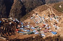
Khumbu

Khumbu (also known as the Everest Region)[1] is a region of northeastern Nepal on the Nepalese side of Mount Everest. It is part of the Solukhumbu District, which in turn is part of Province No. 1.[2] Khumbu is one of three subregions of the main Kirat Kulung and Sherpa settlement of the Himalaya, the other two being Solu and . It includes the town of Namche Bazaar as well as the villages of Thame, Khumjung, Pangboche, Pheriche and Kunde. The famous Buddhist monastery at Tengboche is also located in the Khumbu.[3]
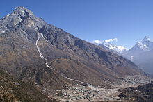

The Khumbu's elevation ranges from 3,300 metres (11,000 feet) to the 8,848.86 m (29,032 ft) summit of Mount Everest, the highest place on Earth.[4] The Khumbu region includes both Sagarmatha National Park (above ) and the Sagarmatha National Park Buffer Zone, between Lukla and Monju.[2]
The Khumbu is a glacier believed to be the result of the last great Ice Age, ~500,000 years ago.
Lonely Planet has ranked Khumbu region in sixth best region in the world to travel.[5]

Villages in the Khumbu region[]
- Dingboche
- Kunde
- Khumjung
- Lobuche
- Lukla
- Namche Bazaar
- Tengboche
- Phortse
- Thame
- Pangboche
- Phakding
- Monjo
References[]
- ^ Khumbu Everest region
- ^ a b Bradley, Mayhew; "Trekking in the Nepal Himalaya"; (2009); 9 edição; pp 84-141; Lonely Planet; ISBN 978-1-74104-188-0.
- ^ Bonington, Chris; Everest, The Hard Way; (1977); pp 72-75; Arrow Books editions; ISBN 0-09-915940-6.
- ^ Boukreev, Anatoli; The Climb;(1988); St. Martin's edition; ISBN 0-312-96533-8.
- ^ http://www.lonelyplanet.com/best-in-travel/regions/06-khumbu?detail=1
External links[]
 Khumbu travel guide from Wikivoyage

- Regions of Nepal
- Solukhumbu District
- Khumbu Pasanglhamu
- Mountain ranges of Nepal