Khumjung
Khumjung
खुम्जुङ | |
|---|---|
Neighborhood | |
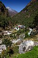
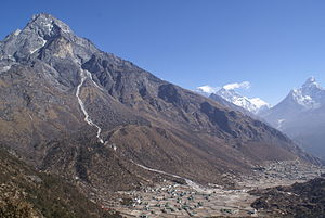 The mountain Khumbila above the villages Khumjung and Kunde. In the background you can see Mount Everest, Lhotse and Ama Dablam | |
 Khumjung (ward no. 4) is north-eastern village of Khumbu Pasanglhamu | |
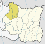
 Khumjung Location in Province | |
| Coordinates: 27°49′N 86°43′E / 27.817°N 86.717°ECoordinates: 27°49′N 86°43′E / 27.817°N 86.717°E | |
| Country | |
| Province | Province No. 1 |
| District | Solukhumbu |
| Rural Municipality | Khumbu Pasanglhamu |
| Located at | ward no. 4 |
| Elevation | 3,790 m (12,430 ft) |
| Population (2011) | |
| • Total | 1,912 |
| Time zone | UTC+5:45 (Nepal Time) |
| Area code(s) | 038 |


Khumjung (Nepali: खुम्जुंग) is a village in Khumbu Pasanglhamu rural municipality of Solukhumbu District in Province No. 1 of north-eastern Nepal. It is located in the Khumbu subregion inside Sagarmatha National Park, a world heritage site. The village is at an elevation of 3,790 metres above sea level, and is situated near Mount Khumbila.
A monastery in Khumjung has a purported Yeti scalp. This village has modern communications such as the internet and mobile and landline phones.
The village is the seat of ward no. 4, which include Kunde, Khumjung, Tengboche (Tyangboche), Pangboche, Pheriche, Dole, Chharchung, Machhermo, Lobuche, Dingboche, and Gokyo. As of 2011, it had a population of 1912 people living in 551 individual households.[1]
Khumjung school was built by Sir Edmund Hillary's Himalayan Trust in 1961. The school began as two classrooms but now caters for pre-school, primary and secondary sections with over 350 students.[2]
History[]
Khumjung was a separate Village development committee in Solukhumbu District of Sagarmatha Zone of EDR in Nepal during Kingdom of Nepal. With new administrative structure on 10 March 2017, it became part of Khumbu Pasanglhamu rural municipality.
Galleries[]
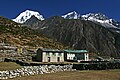
- Khumjung village
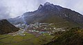
Khumjung village and Mount Khumbila
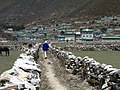
Khumjung village


- VDC Khumjung - Villages and hamlets
Phakding
Jorsale

Dhole
Machhermo

Thangna

Chhukung
Deboche
Tengboche


References[]
- ^ "National Population and Housing Census 2011". Village Development Committee/Municipality. Government of Nepal. Archived from the original (PDF) on 2008-10-12. Retrieved 2018-05-18.
- ^ Ryōhei Uchida (1991), Trekking Mount Everest, San Francisco Chronicle Books, ISBN 978-0-87701-884-1 page 51
External links[]
| Wikimedia Commons has media related to Khumjung. |
Headquarter: Salleri | ||
| Municipality |
|  |
| Rural Municipalities |
| |
This article about a location in Solukhumbu District, Nepal is a stub. You can help Wikipedia by . |
- Populated places in Solukhumbu District
- Khumbu Pasanglhamu
- Solukhumbu District geography stubs