Western Rukum District
Western Rukum District
पश्चिमी रुकुम | |
|---|---|
District | |
 | |
 Location of West Rukum District (dark yellow) in Karnali | |
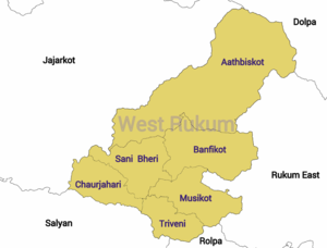 Division of West Rukum | |
| Coordinates: 28°38′N 82°29′E / 28.63°N 82.49°ECoordinates: 28°38′N 82°29′E / 28.63°N 82.49°E | |
| Country | |
| Province | Karnali Province |
| Established | 2015 |
| Admin HQ. | Musikot |
| Government | |
| • Type | Coordination committee |
| • Body | DCC, Western Rukum |
| Area | |
| • Total | 1,213.49 km2 (468.53 sq mi) |
| Population | |
| • Total | 154,272 |
| • Density | 130/km2 (330/sq mi) |
| Time zone | UTC+05:45 (NPT) |
| Website | dccrukumwest |

Western Rukum (Nepali: पश्चिमी रुकुम ) a part of Karnali Province, is one of the seventy-seven districts of Nepal.[1] Musikot is the headquarter of the district.
Formally Western Rukum District was part of Rukum District, which divided into two districts Western Rukum and Eastern Rukum after the state's reconstruction of administrative divisions as of 20 September 2015.
The total area of Western Rukum District is 1,213.49 square kilometres (468.53 sq mi) and total population of this district as of 2011 Nepal census is 154,272 individuals.[1][2]
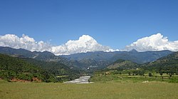
Located in the western hill region, Western Rukum is a hill district with many valleys. It is bordered with five districts: Eastern Rukum and Rolpa district of Lumbini province on the east, Salyan district to the south, Jajarkot district on the west, and Dolpa district to the north.
Demographics[]
At the time of the 2011 Nepal census, Western Rukum had a population of 154,272.[3]
Chhetris are the main group in the district, making up 53.9% of the population. Kami are the second largest with 15.4% and Magars are 14.7% of the population. Thakuris and Bahun are 5% and 3.8% of the population, while other Khas Dalits Damai and Sarki are 3.7% and 1.8% of the population.[3]
99.3% of the population speaks Nepali at home.[3]
Transport[]
Though Western Rukum is considered a remote district, transportation has been rapidly expanded after the Second People's Movement of 2006. With recent building of roads, bus and jeep services are available with links to the southern plains and major cities including Kathmandu. Two airports offer safe but rudimentary facilities for passenger flights, mainly from Nepalganj and Kathmandu.
The Rapti Highway was under construction (as of 2010) to connect Musikot to Salyan Khalanga, Tulsipur, and Mahendra Highway to the south. On the other hand, Nepal's dream project "Mid-Hill Highway" is under construction.
Rapti Highway[]
It is about a four-hour bus ride from Dang Tulsipur to Western Rukum Musikot.
Mid-Hill Highway[]
Mid-Hill Highway is under construction. It is a national pride project that passes through 12 zones, 24 districts, and 215 VDCs(old divisions). With a total length of 1,767 km, the highway connects Chiyo Bhanjyang of Panchthar district in the east with Jhulaghat of Baitadi district in the west.
The bus ride from Kathmandu takes up to 24 hours to Musikot.
Airports[]
The two airports in Western Rukum are in Chaurjahari (Nepali: चौरजहारी) and Salle (Nepali: सल्ले).
Chaurjahari Airport lies near the Bheri River, 762 m above sea level and accessible by footpaths and horse trails only, with a grass runway 850 m long and 30 m wide. It was the primary mode of travel to Rukum for government, NGO personnel, aid workers and backpackers before the civil war. During the conflict the security situation deteriorated and the local police station was shut down. The airport has 10 aircraft parking spaces.
The flight from Nepalganj to Rukum Salle airport takes 15–20 minutes.
Rukum Salle Airport lies near Musikot, the district headquarters. It is accessible by foot way and road transport since Rapti Highway has touched Salle airport. Its runway is 650 meters long with capability of parking of four aircraft.
The flight from Kathmandu to Rukum Salle airport takes about 90 minutes, while the flight from Nepalganj takes about 20 minutes.
The district is divided into 3 urban municipalities and 3 rural municipalities[1][4]
Urban municipalities[]
Rural municipalities[]
- Banphikot
- Tribeni
- Sani Bheri
References[]
- ^ a b c "स्थानीय तहहरुको विवरण" [Details of local level body]. www.mofald.gov.np (in Nepali). Ministry of Federal Affairs and Local Development (Nepal). Retrieved 14 April 2018.
- ^ "CITY POPULATION– statistics, maps & charts". www.citypopulation.de. 8 October 2017. Retrieved 14 April 2018.
- ^ a b c "Natioanl Data Portal-Nepal". nationaldata.gov.np. Retrieved 2021-08-10.
- ^ "District Corrected Last for RAJAPATRA" (PDF). www.mofald.gov.np. Ministry of Federal Affairs and Local Development (Nepal). Retrieved 14 April 2018.
External links[]
Headquarters: Musikot | ||
| Urban municipalities |  | |
| Rural municipalities | ||
| Former VDCs | for former VDCs, see Rukum District | |
- Western Rukum District
- Districts of Nepal established in 2015
- Districts of Karnali Province