Sarlahi District
This article should specify the language of its non-English content, using {{lang}} or {{transl}} (or {{IPA}} or similar for phonetic transcriptions), with an appropriate ISO 639 code. (August 2021) |
Sarlahi District
सर्लाही जिल्ला | |
|---|---|
District | |
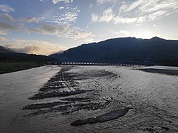 Bagmati River at Sarlahi | |
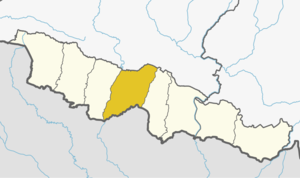 Sarlahi District (dark yellow) in Province No. 2 | |
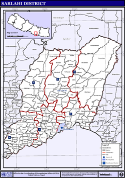
 Sarlahi District with local level body | |
| Country | |
| Province | Province No. 2 |
| Admin HQ. | Malangwa |
| Government | |
| • Type | Coordination committee |
| • Body | DCC, Sarlahi |
| Area | |
| • Total | 1,259 km2 (486 sq mi) |
| Population (2011) | |
| • Total | 769,729 |
| • Density | 610/km2 (1,600/sq mi) |
| Time zone | UTC+05:45 (NPT) |
| Telephone Code | 046 |
| Main Language(s) | Bhojpuri, Bajjika, Maithili and Nepali |
| Website | www |
Sarlahi (Nepali: सर्लाही ![]() Listen (help·info); Maithili: सर्लाही), a part of Province No. 2, is one of the seventy-seven districts of Nepal. According to new laws, a combination of more than two or four villages makes a municipality, which covers an area of 1,259 km2 (486 sq mi) and had a population of 635,701 in 2001 and 769,729 in 2011.[1]
Listen (help·info); Maithili: सर्लाही), a part of Province No. 2, is one of the seventy-seven districts of Nepal. According to new laws, a combination of more than two or four villages makes a municipality, which covers an area of 1,259 km2 (486 sq mi) and had a population of 635,701 in 2001 and 769,729 in 2011.[1]
It is bordered to the west by the Bagmati River, to the east by Mahottari District, to the north by the Sivalik Hills, and to the south by Bihar State of India.
Etymology[]
Generally, the people of Sarlahi believe that the name Sarlahi comes from the name of the Sarla Devi temple. The Sarla Devi temple is situated in Hempur village in the Sarlahi district. There is a belief that if someone goes to the temple at night with a light, then that person will die. For that reason, people still do not go at night to that temple with light. There are no residences around this temple.[2]
Famous for[]
The district is known for a couple of things. One of them is tomato production and supply. Lalbandi is the place of this district which is known for supplying the tomato demand of the whole country. Scientific tomato farming was practiced in Sarlahi district at Bagwani Kendra Nawalpur, Netragunj. Lalbandi is the most famous for growing tomatoes in the country. It is also known as the tomato capital of Nepal. is the village which is famous for fish production and export. The production of sugarcane is also seems to be significant in the district. The Indushankr Chini Udhog Ltd. (Indushankr Sugar Mills) is a notable factory in the district.[2]
The Annapurna Sugars and General Industries Pvt Ltd. is probably one of the largest sugar mills in the country, located in Dhankaul VDC of Sarlahi. The plant commenced trial operations on January 17, 2014, with a successful crushing of over 16 lakh (1,600,000) quintals of cane. The mill will substantially help in meeting sugar requirements of the local Nepal market by producing around 300,000 quintals of white sugar. The mill is equipped with modern machinery to produce high-quality sugar. It helps to support the livelihood of thousands of people including farmers, employees and laborers. [3]
The historical is famous among different religious groups because of its typical geographical location. It is located in a strategic place bordering four districts: Makawanpur, Sarlahi, Rautahat and Sindhuli. World Heritage the historical temple is the best known religious place here which was located in Murtiya village of Sarlahi district.[clarification needed] The Nadiman lake, an important Puranic place, is located nearby Malangawa which is believed to be the yaksha pool (kunda), the mystic lake owned by the yaksha himself. The Pattharkot temple is also the best known religious place here. The Sitlamai temple, Bajrangbali temple, Durga temple, Gadhimai temple and Laxmipur Pokhari in Balara Municipality.[clarification needed] The Sagaranatha temple in Iswarpur, the Gopalkuti Mahadev temple in Karmaiya, among many others, are equally significant places in Sarlahi. The famous Barahathawa Bazaar is also located here, which is growing as a commercial hub of the district.
Geography and climate[]
| Climate Zone[4] | Elevation Range | % of Area |
|---|---|---|
| Lower Tropical | below 300 meters (1,000 ft) | 88.3% |
| Upper Tropical | 300 to 1,000 meters 1,000 to 3,300 ft. |
11.7% |
Geographical division[]
According to geographical texture Sarlahi district is divided into three parts.[5]
- of north
- Bhanwar region of middle
- Terai region of south
Chure mountain[]
On the north side of the district from east to west is the mountain range known as the Sivalik Hills. They have an average height of 900 metres (3,000 ft), reaching 1,350 metres (4,430 ft) in places. This range separates the Terai from the inner Terai and harbours the fossilised remains of many mammals no longer typical of Eurasia.[6]

Bhanwar region[]
This region is between what is north of the Sivalik hills and the southern Terai region. In the local language, it is also known as char koshe jhadi and thethi. The height of the region is from 150 to 300 metres (490 to 980 ft). The Mahendra Highway touches this area, so settlement is increasing. In the region, the water source level is always very low; even the following water disappears because of sandiness. It is very difficult to obtain water by digging. Irrigation is problematic in the area.[5]
Terai region[]
The Terai region begins in the middle of the district to the south and goes to India's Bihar. Since ancient times, the region has had large public density and is a good place for farming, so it is called Treasurer of grain.[5]
Rivers[]
There are four major rivers in this district that flow into India: the Bagmati, the Hardi (Banke), the Lakhandei and the Jhim. However, there are around a dozen other small rivulets that originate from the Chure hills and flow down the plain. They are actually the tributaries of the three major river systems of the district. These small rivulets are the Hariwan khola, the Dhungre khola, the Soti khola, the Sotraha khola, the Chapini khola, the Pathlaiya khola, he Kalinjor khola, the Phooljor khola and the Banke Khola. The Banke Khola is the eastern demarcation of the district separating it from Mahottari district, whereas the Bagmati river flows between Sarlahi and Rautahat districts.
- : it is the largest river, flowing in the western side of district separating Rautahat district from Sarlahi.
- : this river is the largest river inside the district; it is about 25 kilometers long. It originates from the Chure Mountain range, the lowest foothills of the Great Himalayan ranges. It flows into India by touching Simara village development committee (VDC) of this district.
- : originating from the northeast side of the Chure mountains of this district into the Phuljor and Kalinjor rivers, it joins at the Vairawpur village of Jabdi VDC, then it becomes Jhim river. It is 29 km (18 mi) long and by flowing into districts passes into India, and in India this river is known as . Adhwara river was the east border of Makwanpur region.
. Banke river was the east border of Sarlhi district. There are also many rivers in this district including the Adhwara River of the east which empties into the Jhim River, (which is formed by mixing Harion, Sotara and Pathlaiya rivers), and in middle of the district Dhangra and Bhumi rivers.[5]
- : this river is the largest river inside the district; it is about 25 kilometers long. It originates from the Soram range, the lowest foothills of the Great Himalayan ranges. It flows into India by touching VDC of this district.
Demography[]
According to the 2011 census, the total population of the district is 769,729; among them the male population is 389,756 and the female population is 379,973. The total Hindu population is 658,611, which is about 85% of the total population, while the total Muslim population is 60,679, which is about 8% of the total population. The total Buddhist population is 44,011, which is about 5.71% of the total population, while the total Christian population is 1,752, which is about 0.22% of the total population. The most populous communities are Yadavs, Kushwahas and Muslims.[7]
49.0% speak Bajjika, 21.2% Maithili, 11.8% Nepali, 6.3% Urdu, 4.8% Tamang, 2.1% Tharu, 1.4% Magar, 0.9% Bhojpuri and 0.5% Danuwar as their first language.
36.3% of the population in the district speak Hindi, 20.8% Nepali, 4.5% Bajjika, 3.8% Maithili and 0.7% Bhojpuri as their second language.[8]
Media[]
From Sarlahi district, newspapers and FM radio stations are as follows:[9]
Newspapers: Paricharcha, Madhesh Post Daily, Suchna Saugat Weekly, Sarlahi Awaz Weekly, and Sarlahi Times Weekly.
| Name | Frequency Range | Location | Status→←≥ |
|---|---|---|---|
| Samudayak Radio Sarlahi | 105.7 MHz | Hariyon | Broadcast |
| Swarnim FM | 96.3 MHz | Malangwa | Broadcast |
| Radio Madhesh | 89.3 MHz | Malangwa | Broadcast |
| Radio Ekta | 92.4 MHz | Lalbandi | Broadcast |
| Radio Dhukdhuki | 95.6 MHz | Lalbandi | Broadcast |
| Radio Mukteshower | 100.4 MHz | Barahatwa | Broadcast |
| Radio Barahathawa | 101.1 MHz | Barahathawa | Broadcast |
Sarlahi constituencies[]
There are a total of four electoral constituencies in Sarlahi named Kshetra numbers 1 to 4.[10]
Administration[]
The district consists of twenty municipalities, out of which eleven are urban municipalities and nine are rural municipalities. These are as follows:
- Bagmati Municipality
- Balara Municipality
- Barahathwa Municipality
- Godaita Municipality
- Harion Municipality
- Haripur Municipality
- Haripurwa Municipality
- Ishworpur Municipality
- Kabilasi Municipality
- Lalbandi Municipality
- Malangwa Municipality
- Basbariya Rural Municipality
- Bishnu Rural Municipality
- Brahampuri Rural Municipality
- Chakraghatta Rural Municipality
- Chandranagar Rural Municipality
- Dhankaul Rural Municipality
- Kaudena Rural Municipality
- Parsa Rural Municipality
- Ramnagar Rural Municipality
Former Village Development Committees (VDCs)[]
- Achalgadh
- Arnaha
- Aurahi
- Babarganj
- Bahadurpur
- Balara
- Bara Udhoran
- Barahathawa
- Basantapur
- Batraul
- Bela
- Belhi
- Belwajabdi
- Bhadsar
- Bhagawatipur
- Bhaktipur
- Bhawanipur
- Brahmapuri
- Chandranagar
- Chhataul
- Chhatona
- Dhanakaul Purba
- Dhangada
- Dhungrekhola
- Dumariya
- Gadahiyabairi
- Gamhariya
- Godeta
- Gaurishankar
- Hajariya
- Harakthawa
- Haripur
- Haripurwa
- Hariwan Municipality
- Hathiyol
- Hempur
- Ishwarpur
- Jabdi
- Jamuniya
- Janaki Nagar
- Jingadawa
- Kabilasi
- Kalinjor
- Karmaihiya
- Khairwa
- Khoriya
- Kisanpur
- Kaudena
- Lalbandi
- Laukat
- Laksmipur Kodraha
- Laksmipur Su.
- Madhubangoth
- Mahinathpur
- Mailhi
- Malangawa Municipality
- Manpur
- Masaili
- Mirjapur
- Mohanpur
- Motipur
- Murtiya
- Musauli
- Narayan Khola
- Narayanpur
- Netraganj
- Naukailawa
- Parsa
- Parwanipur
- Pattharkot
- Pharahadawa
- Phulparasi
- Pidari
- Pidariya
- Pipariya
- Rajghat
- Ranban
- Raniganj
- Rohuwa
- Salempur
- Sangrampur
- Sankarpur
- Shahorwa
- Shreepur
- Sikhauna
- Simara
- Sisaut
- Shankarpur
- Sohadawa
- Sudama
- Sundarpur
- Tribhuwannagar
See also[]
- Zones of Nepal
- "Districts of Nepal". Statoids.
References[]
- ^ "National Population and Housing Census 2011 (National Report)" (PDF). Central Bureau of Statistics. Archived from the original (PDF) on 2013-05-25. Retrieved 1 November 2012.
- ^ Jump up to: a b जिल्ला विकास समितिको कार्यालय, सर्लाही. "जिविसको वस्तुगत स्थितिको झलक". Archived from the original on 2014-06-06. Retrieved 2013-12-12.
- ^ http://www.rkinepal.com/annapurna/
- ^ The Map of Potential Vegetation of Nepal - a forestry/agroecological/biodiversity classification system (PDF), Forest & Landscape Development and Environment Series 2-2005 and CFC-TIS Document Series No.110., 2005, ISBN 87-7903-210-9, retrieved Nov 22, 2013
- ^ Jump up to: a b c d जिल्ला विकास समितिको कार्यालय, सर्लाही. "भौगोलिक अवस्थिति". Archived from the original on 2014-06-06. Retrieved 2013-12-12.
- ^ "Geography of Nepal". nepaltourtravels.com. Retrieved 2013-12-12.
- ^ http://unstats.un.org/unsd/demographic/sources/census/2010_PHC/Nepal/Nepal-Census-2011-Vol1.pdf
- ^ 2011 Nepal Census, Social Characteristics Tables
- ^ sarlahi development. "News Paper Publish in Sarlahi District". Retrieved 2013-12-12.
- ^ http://election.gov.np/election/uploads/files/document/%E0%A4%AE%E0%A4%A4%E0%A4%A6%E0%A4%BE%E0%A4%A8_%E0%A4%95%E0%A5%87%E0%A4%A8%E0%A5%8D%E0%A4%A6%E0%A5%8D%E0%A4%B01.pdf
External links[]
| Wikimedia Commons has media related to Sarlahi District. |
Coordinates: 26°51′21″N 85°33′44″E / 26.855712°N 85.562360°E

- Sarlahi District
- Districts of Nepal established during Rana regime or before
- Districts of Province No. 2