Kalikot District
Kalikot District
कालीकोट जिल्ला | |
|---|---|
District | |
 Jite Gadhi over the Karnali in Kalikot district | |
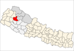
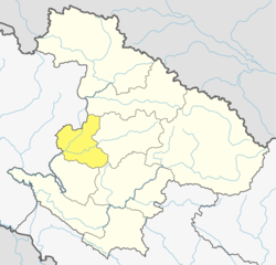 Location of Kalikot District (dark yellow) in Karnali | |
| Country | |
| Province | Karnali Pradesh |
| Admin HQ. | Manma (today part of Khandachakra Municipality) |
| Government | |
| • Type | Coordination committee |
| • Body | DCC, Kalikot |
| Area | |
| • Total | 1,741 km2 (672 sq mi) |
| Population (2011) | |
| • Total | 136,948 |
| • Density | 79/km2 (200/sq mi) |
| Time zone | UTC+05:45 (NPT) |
| Website | ddckalikot |
Kalikot District (Nepali: कालीकोट जिल्ला ![]() Listen (help·info)), a part of Karnali province, is one of the seventy-seven districts of Nepal. The district, with Manma as its district headquarters, covers an area of 1,741 km2 (672 sq mi), had a population of 105,580 in 2001 and 136,948 in 2011. In September 2005, in a bid to encourage a change in social attitudes, the government announced that it would provide rice to any family that had recently had a girl born.[1]
Listen (help·info)), a part of Karnali province, is one of the seventy-seven districts of Nepal. The district, with Manma as its district headquarters, covers an area of 1,741 km2 (672 sq mi), had a population of 105,580 in 2001 and 136,948 in 2011. In September 2005, in a bid to encourage a change in social attitudes, the government announced that it would provide rice to any family that had recently had a girl born.[1]
Geography and Climate[]
| Climate Zone[2] | Elevation Range | % of Area |
|---|---|---|
| Upper Tropical | 300 to 1,000 meters 1,000 to 3,300 ft. |
1.8% |
| Subtropical | 1,000 to 2,000 meters 3,300 to 6,600 ft. |
20.6% |
| Temperate | 2,000 to 3,000 meters 6,400 to 9,800 ft. |
39.4% |
| Subalpine | 3,000 to 4,000 meters 9,800 to 13,100 ft. |
37.3% |
| Alpine | 4,000 to 5,000 meters 13,100 to 16,400 ft. |
0.8% |
Demographics[]
At the time of the 2011 Nepal census, Kalikot District had a population of 136,948. Of these, 99.5% spoke Nepali as their first language.[3]
The largest ethnic group is the Khas Chhetri which are 28.8% of the total population, The second largest group is Thakuri which is 25.1% of the total population. 17.7% are Kami, 17.1% Hill Brahmin, 5.1% Damai and 3.2% Sarki.[3]
Administration[]
The district consists of nine municipalities, out of which four are urban municipalities and five are rural municipalities. These are as follows:[4]
- Khandachakra Municipality
- Raskot Municipality
- Tilagufa Municipality
- Pachaljharana Rural Municipality
- Sanni Triveni Rural Municipality
- Narharinath Rural Municipality
- Shubha Kalika Rural Municipality
- Mahawai Rural Municipality
- Palata Rural Municipality
Former Village Development Committees[]
Prior to the restructuring of the district, Kalikot District consisted of the following municipalities and Village development committees:

See also[]
- Zones of Nepal
- Paudhur
References[]
- ^ Country Reports on Human Rights Practices - 2005 - US Department of State
- ^ The Map of Potential Vegetation of Nepal - a forestry/agroecological/biodiversity classification system (PDF), Forest & Landscape Development and Environment Series 2-2005 and CFC-TIS Document Series No.110., 2005, ISBN 87-7903-210-9, retrieved Nov 22, 2013
- ^ Jump up to: a b 2011 Nepal Census, Social Characteristics Tables
- ^ "स्थानिय तह" (in Nepali). Ministry of Federal Affairs and General Administration. Archived from the original on 31 August 2018. Retrieved 1 September 2018.
External links[]
Coordinates: 29°9′0″N 81°37′0″E / 29.15000°N 81.61667°E

| Wikimedia Commons has media related to Kalikot District. |
This article about a location in the Kalikot District of Nepal is a stub. You can help Wikipedia by . |
- Kalikot District
- Districts of Nepal established in 1962
- Districts of Karnali Province
- Karnali Province geography stubs