Panchthar District
Panchthar District
पाँचथर जिल्ला | |
|---|---|
District | |
 Location of Panchthar district | |
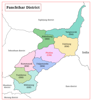 Divisional map of Panchthar district | |
| Country | |
| Province | 1 |
| Admin HQ. | Phidim |
| Government | |
| • Type | Coordination committee |
| • Body | DCC, Panchthar |
| Area | |
| • Total | 1,241 km2 (479 sq mi) |
| Population (2011[1]) | |
| • Total | 191,817 |
| • Density | 150/km2 (400/sq mi) |
| Time zone | UTC+05:45 (NPT) |
Panchthar district (Nepali: पाँचथर जिल्ला![]() Listen (help·info)) is one of 14 districts of Province No. 1 of eastern hilly region of Nepal. It is a Hill district of eastern Nepal. The district covers 1,241 km2 (479 sq mi) of area. The 2011 census counted 191,817 population. Phidim is the district headquarters.
Listen (help·info)) is one of 14 districts of Province No. 1 of eastern hilly region of Nepal. It is a Hill district of eastern Nepal. The district covers 1,241 km2 (479 sq mi) of area. The 2011 census counted 191,817 population. Phidim is the district headquarters.
History[]
Panchthar was a part of Old Dhankuta District during Rana era and until 1962. Dhankuta district had two subdivisions Chhathum and Terhathum. Panchthar was a thum (county) under the Terhathum subvision. It became a separate district in 1962 when the old 32 traditional districts divided into 75 district.
Geography and climate[]
| Climate Zone[2] | Elevation Range | % of Area |
|---|---|---|
| Upper Tropical | 300 to 1,000 meters 1,000 to 3,300 ft. |
18.3% |
| Subtropical | 1,000 to 2,000 meters 3,300 to 6,600 ft. |
52.6% |
| Temperate | 2,000 to 3,000 meters 6,400 to 9,800 ft. |
23.9% |
| Subalpine | 3,000 to 4,000 meters 9,800 to 13,100 ft. |
4.7% |
| Alpine | 4,000 to 5,000 meters 13,100 to 16,400 ft. |
0.4% |
Demographics[]
At the time of the 2011 Nepal census, Panchthar District had a population of 191,817. Of these, 42% were Limbu, Rai 14%, Brahmin 11%, Chettrai 10%, Tamang 7%, Magar 3%, Kami 3%, Damai 2% Gurung 2% and Others 6%. Similarly, 40.1% spoke Limbu, 34.1% Nepali, 6.5% Tamang, 5.5% Bantawa, 5.2% Rai , 2.9% Magar, 1.1% Gurung, 0.7% Sunuwar, 0.7% Chamling, and 0.5% Newari as their first language.
62.0% of the population in the district spoke Nepali and 0.8% Limbu as their second language.[3]
Literacy Rate: 72.58% (2011 Census)
Poverty Rate: 11.4% (2011 Census)
Forest Cover: 54.89%
Municipality and Rural Municipalities of Panchthar[]
- Phidim Municipality Nepali: फिदिम नगरपालिका (Phidim Municipality, Ranitar, Lumphabung, Yangnam(1-5), Nangin, Lungrupa)
- Hilihang Rural Municipality Nepali: हिलिहाङ गाउँपालिका (Ambarpur, Panchami, Subhang, Bharapa)
- Kummayak Rural Municipality Nepali: कुम्मायाक गाउँपालिका (Yasok, Rani Gaun, Mangjabung, Syabarumba
- Miklajung Rural Municipality Nepali: मिक्लाजुंग गाउँपालिका (Aarubote, Sarangdanda, Rabi, Kurumba, Limba, Durdimba)
- Phalelung Rural Municipality (Nepali: फालेलुंग गाउँपालिका (Ektin, Memeng, Prangbung, Yangnam(6,9) Sidin)
- Phalgunanda Rural Municipality (Nepali: फाल्गुनन्द गाउँपालिका (Nawamidanda, Imbung, Pauwa Sartap, Chilingdin, Aangsarang, Phaktep)
- Tumbewa Rural Municipality Nepali: तुम्वेवा गाउँपालिका (Aangna, Olane, Hangum, Mauwa)
- Yangawarak Rural Municipality Nepali: याङवरक गाउँपालिका (Chyangthapu, Phalaicha, Oyam, Tharpu, Nagi)
VDC's in small brackets means they are combined to form main Rural Municipality
Previous Village Development Committees (VDCs) and Municipalities[]

- Aangna
- Aangsarang
- Ambarpur
- Bharapa
- Chilingdin
- Chyangthapu
- Durdimba
- Ektin
- Embung
- Phalaicha
- Hangum
- Kurumba
- Limba
- Lungrupa
- Mangjabung
- Mauwa
- Memeng
- Nagi
- Nangin
- Nawamidanda
- Olane
- Oyam
- Panchami
- Prangbung
- Pauwa Sartap
- Phaktep
- Phidim Municipality
- Prangbung
- Rabi
- Rani Gaun
- Ranitar
- Sarangdanda
- Sidin
- Subhang
- Syabarumba
- Tharpu
- Yangnam
- Yasok
People from Panchthar District[]
- Bairagi Kainla
- Bhishmaraj Angdembe
- Damber Singh Sambahamphe
- Ganesh Prasad Rijal
- Kumar Lingden
- Rambahadur Limbu
- Upendra Subba
See also[]
- Zones of Nepal
References[]
- ^ Household and population by districts, Central Bureau of Statistics (CBS) Nepal Archived 2013-07-31 at the Wayback Machine
- ^ The Map of Potential Vegetation of Nepal - a forestry/agroecological/biodiversity classification system (PDF), Forest & Landscape Development and Environment Series 2-2005 and CFC-TIS Document Series No.110., 2005, ISBN 87-7903-210-9, retrieved Nov 22, 2013
- ^ 2011 Nepal Census, Social Characteristics Tables
| Wikimedia Commons has media related to Panchthar District. |
- "Districts of Nepal". Statoids.
| show Places adjacent to Panchthar District |
|---|

| show Authority control |
|---|
Coordinates: 27°12′N 87°50′E / 27.20°N 87.83°E

This article about a location in the Panchthar District of Nepal is a stub. You can help Wikipedia by . |
- Panchthar District
- Districts of Nepal established in 1962
- Districts of Province No. 1
- Province No. 1 geography stubs