Thamserku
| Thamserku | |
|---|---|
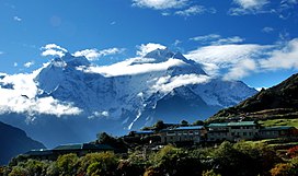 Dole village and Mt. Thamserku (to the right) and Kangtega (to the left) in the background | |
| Highest point | |
| Elevation | 6,608 m (21,680 ft)[1] |
| Prominence | 623 m (2,044 ft) |
| Coordinates | 27°47′25″N 86°47′15″E / 27.79028°N 86.78750°ECoordinates: 27°47′25″N 86°47′15″E / 27.79028°N 86.78750°E |
| Geography | |
 Thamserku Location in eastern Nepal | |
| Location | Khumbu, Nepal |
| Parent range | Himalayas |
| Climbing | |
| First ascent | 1964 by Lynn Crawford, Peter Farrell, John McKinnon, Richard Stewart[2] |
| Easiest route | snow/ice climb |


Thamserku is a mountain in the Himalayas of eastern Nepal. The mountain is connected by a ridge leading eastward to Kangtega. Thamserku is a prominent mountain to the east of Namche Bazaar and lies just north of Kusum Kangguru.[citation needed]
The first ascent was made in 1964 from the south by members of Edmund Hillary's Schoolhouse Expedition: Lynn Crawford, Pete Farrell, John McKinnon and Richard Stewart. Below the basin on the southwest face, they reached the south ridge after climbing a difficult couloir. The team described the climb as difficult and the route has not been repeated in its entirety by anyone else.[2] In 2014, Russian climbers Alexander Gukov and Alexey Lonchinskiy made the first ascent on the southwest face.[2]
References[]
- ^ Nepa Maps (Pvt.Ltd.), NE517: Everest Base Camp & Gokyo, Kathmandu, Nepal, 2013
- ^ Jump up to: a b c Griffin, Lindsay (2015). "Thamserku, Southwest Face, Shy Girl". Climbs And Expeditions. American Alpine Journal. New York, NY, USA: American Alpine Club. 14 (89). Retrieved 2016-06-28.
External links[]
 Media related to Category:Thamserku at Wikimedia Commons
This article related to a mountain or hill in Nepal is a stub. You can help Wikipedia by . |
- Mountains of the Province No. 1
- Six-thousanders of the Himalayas
- Nepal mountain stubs