Ruurlo
Ruurlo | |
|---|---|
Dorp | |
 Flag  Coat of arms | |
| Coordinates: 52°5′14″N 6°27′28″E / 52.08722°N 6.45778°E | |
| Country | Netherlands |
| Province | Gelderland |
| Municipality | Berkelland |
| Area | |
| • Total | 54.94 km2 (21.21 sq mi) |
| Population (2008) | 7,830 |

|
| |
| Country | Netherlands |
| Province | Gelderland |
| Area - Land - Water |
65.19 km² 64.96 km² 0.23 km² |
| Population (2004) - Density |
8,676 134/km² |

Ruurlo is a town and former municipality in the province of Gelderland in the eastern part of the Netherlands. In 2004 it had a population of 8,676.
The town has a station on the Zutphen to Winterswijk railway line, and is served by trains every half-hour in both directions. In the evening there is an hourly service.
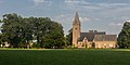
Ruurlo Castle lies just outside the town and is a popular place for weddings. The castle was used as the town hall until 1 January 2005, when the municipality Ruurlo merged with the municipalities of Borculo, Neede and Eibergen into the municipality of Berkelland.
Population centres[]
, , , Heurne, , Ruurlo and .
Transportation[]
- Railway station: Ruurlo
Gallery[]

Ruurlo, Ruurlo castle
Ruurlo, reformed church
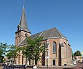
Ruurlo, church: de Sint Willibrorduskerk
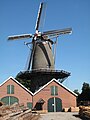
Ruurlo, windmill: houtzaagmolen de Agneta


External links[]
- Official Website
- J. Kuyper, Gemeente Atlas van Nederland, 1865-1870, "Ruurlo". Map of the former municipality, around 1868.
| Wikimedia Commons has media related to Ruurlo. |
Coordinates: 52°05′N 6°27′E / 52.083°N 6.450°E
This Gelderland location article is a stub. You can help Wikipedia by . |
- Populated places in Gelderland
- Former municipalities of Gelderland
- Berkelland
- Gelderland geography stubs