Ryndon, Nevada
Ryndon, Nevada | |
|---|---|
 | |
 Ryndon | |
| Coordinates: 40°56′31″N 115°35′44″W / 40.94194°N 115.59556°WCoordinates: 40°56′31″N 115°35′44″W / 40.94194°N 115.59556°W | |
| Country | United States |
| State | Nevada |
| County | Elko |
| Elevation | 5,174 ft (1,577 m) |
| Time zone | UTC-8 (Pacific (PST)) |
| • Summer (DST) | UTC-7 (PDT) |
| ZIP code | 89801 |
| Area code(s) | 775 |
| GNIS feature ID | 856361[1] |
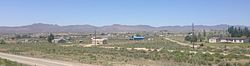
Ryndon is an unincorporated community in central Elko County, Nevada, United States.[1]
Description[]
The community is located on Interstate 80 and the Humboldt River in , about 11 miles (18 km) northeast of Elko.[2]
References[]
- ^ a b U.S. Geological Survey Geographic Names Information System: Ryndon
- ^ Google (27 May 2020). "Ryndon, Nevada 89801" (Map). Google Maps. Google. Retrieved 27 May 2020.
External links[]
Ryndon NV News
![]() Media related to Ryndon, Nevada at Wikimedia Commons
Media related to Ryndon, Nevada at Wikimedia Commons
Municipalities and communities of Elko County, Nevada, United States | ||
|---|---|---|
| Cities | ||
| CDPs | ||
| Other unincorporated communities | ||
| Indian reservations |
| |
| Ghost towns |
| |
| Footnotes | ‡This populated place also has portions in an adjacent county or counties | |
| ||
This Elko County, Nevada state location article is a stub. You can help Wikipedia by . |
Categories:
- Unincorporated communities in Elko County, Nevada
- Unincorporated communities in Nevada
- Elko County, Nevada geography stubs