Sępólno Krajeńskie
Sępólno Krajeńskie | |
|---|---|
 | |
 Flag  Coat of arms | |
 Sępólno Krajeńskie | |
| Coordinates: 53°27′0″N 17°31′48″E / 53.45000°N 17.53000°E | |
| Country | |
| Voivodeship | Kuyavian-Pomeranian |
| County | Sępólno |
| Gmina | Sępólno Krajeńskie |
| Government | |
| • Mayor | Waldemar Stupałkowski |
| Area | |
| • Total | 5.82 km2 (2.25 sq mi) |
| Population (2006) | |
| • Total | 9,258 |
| • Density | 1,600/km2 (4,100/sq mi) |
| Time zone | UTC+1 (CET) |
| • Summer (DST) | UTC+2 (CEST) |
| Postal code | 89-400 |
| Car plates | CSE |
| Website | http://www.gmina-sepolno.pl |

Sępólno Krajeńskie pronounced ['sɛmˈpulnɔ kraˈjɛɲskʲɛ] (German: Zempelburg) is a town in northern Poland, in the Kuyavian-Pomeranian Voivodeship, about 63 kilometres (39 miles) northwest of Bydgoszcz. It is the capital of Sępólno County (powiat sępoleński) and Gmina Sępólno Krajeńskie and has a population of 9,258 (2006).
History[]

The town received Magdeburg rights in 1360 from king Casimir the Great of Poland. It was located in the valley of the River, which flooded the old castle because of its proximity to a nearby lake. Sępólno was a private town and it initially belonged to the Pakoski family, and later also the Ostroróg, Goślubski, Zebrzydowski, Smoszewski, Brez and Potulicki families until 1821.[1] The town formed part of the Kalisz Voivodeship of the Greater Poland Province of the Polish Crown.
During the Thirteen Years' War between Poland and the Teutonic Knights the area was captured by the Knights and the town itself looted. Sępólno suffered during the Swedish invasions and epidemics in the 17th century.[1] In the 18th century the town had a number of weavers, shoemakers and farmers. The Jews of the town traded textiles and other fabricated goods to both Royal Prussia and Duchy of Prussia. A new synagogue was built in 1734.[2]
The town was annexed by the Kingdom of Prussia during the First Partition of Poland in 1772. Fires in 1781 and 1782 destroyed 73 houses, so that there existed now 84 devastated sites in the town.[2] In the year of 1783 the town had altogether 183 houses, most of them having thatched roofs.[2] There was an influx of Jews, who, however, gradually emigrated westwards in the 19th century.[1]
Sępólno was part of the short-lived Polish Duchy of Warsaw in 1807–1815 during the Napoleonic Wars, and afterwards it was re-annexed by Prussia. In 1871 the town became part the German Empire, where as Zempelburg it formed part of the Flatow district of the province of West Prussia. It was a center for the textile and shoemaking industries. Despite Germanisation policies, Poles established various organisations, including the Bank Ludowy ("People's Bank") in 1910.[1]
In 1920, the eastern part of the former Flatow district with the towns of Kamień Krajeński, Więcbork and Sępólno was reintegrated with the restored Polish Republic after the Treaty of Versailles. The town became the seat of Sępólno County.

Sępólno was invaded by Nazi Germany on September 1, 1939,[1] the first day of World War II, and was later annexed and made the seat of within the Reichsgau Danzig-West Prussia. During the German occupation, Poles were subject to persecutions, mass arrests, Germanisation, expulsions and massacres. Numerous Poles were imprisoned in a concentration camp in Radzim and in a prison established by the Selbstschutz in Sępólno, and later murdered on site or deported to other Nazi concentration camps.[3] Mass arrests of Poles were carried out from September 1939,[3] and the first executions of Polish inhabitants were carried out by the Germans at the turn of September and October 1939.[1] Mass executions of Poles in Sępólno were carried out in various places, for example on the railway tracks connecting Sępólno and Kamień Krajeński (in October 1939), at the primary school and at the shooting range (in November 1939),[3] local Poles were also murdered in Radzim, Karolewo, Rudzki Most.[1] Local Jews were also murdered in Radzim.[1] In early 1945 the town was captured by the Soviets, who plundered the town, raped many women, deported Germans to Siberia, and fought the Polish underground resistance movement.[1] Afterwards the town was restored to Poland.
Landmarks of Sępólno Krajeńskie include a Protestant church in the market built in 1857.
Number of inhabitants by year[]

| Year | Population (based in part on Prussian statistics) |
|---|---|
| 1783 | 1,628, including 651 Protestants, 390 Catholics and 581 Jews[2] |
| 1805 | 2,492, including 1,434 Christians and 1,058 Jews[4] |
| 1853 | 3,178, including 1,969 Christians and 1,218 Jews[4] |
| 1875 | 3,516[5] |
| 1880 | 3,736[5] |
| 1890 | 3,510, including 2,011 Protestants, 839 Catholics and 657 Jews (280 Poles)[5] |
| 1905 | 3,810, including 1,246 Catholics and 393 Jews[6] |
| 1910 | 3,818, including 637 Poles |
| 1920 | 3,513 |
| 1931 | 3,318 |
| 1943 | 5,207 |
| 2007 | 9,249 |
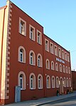
Points of interest[]
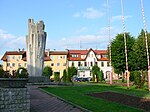
Market place (2012)
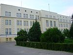
Town Hall
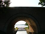
Bridge in the Old Town
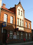
Post office
Public library


Notable residents[]
- Moritz Brasch (1843-1895), philosopher
- (born 1967), Polish international footballer
References[]
- ^ Jump up to: a b c d e f g h i "Historia". Gmina Sępólno Krajeńskie (in Polish). Retrieved 3 May 2020.
- ^ Jump up to: a b c d Johann Friedrich Goldbeck: Vollständige Topographie des Königreichs Preußen. Part II, Marienwerder 1789, pp. 99-100, no. 5). (in German).
- ^ Jump up to: a b c Maria Wardzyńska, Był rok 1939. Operacja niemieckiej policji bezpieczeństwa w Polsce. Intelligenzaktion, IPN, Warszawa, 2009, p. 168 (in Polish)
- ^ Jump up to: a b F. W. F. Schmitt: Topographie des Flatower Kreises. In: Preußische Provinzialblätter, Andere Folge, Band VII, Königsberg 1855, S. 116.
- ^ Jump up to: a b c Michael Rademacher: Deutsche Verwaltungsgeschichte - Kreis Zempelburg (2006) Source: Statistik des Deutschen Reichs. Berlin, 1883.
- ^ Meyers Konversations-Lexikon. 6. Auflage, 20. Band, Leipzig uand Vienna 1909, p. 885.
External links[]
- Official town website (in Polish)
Literature[]
- F. W. F. Schmitt: Topographie des Flatower Kreises. In: Preußische Provinzialblätter, Andere Folge, Vol. VI, Königsberg 1854, pp. 257–289 (Online) and pp. 432–461 (Online), Vol. VII, Königsberg 1855, pp. 42–46 (Online) and pp. 105–118 (Online) (in German)
- Goerke, Otto: Der Kreis Flatow. In geographischer, naturkundlicher und geschichtlicher Beziehung dargestellt. [1. Auflage: 1918] 2. Auflage, Gifhorn 1981, mit einem Nachtrag über die Zeit von 1918 bis 1945 von (902 Seiten, 113 Abbildungen und sieben Karten) (in German)
- Mathias Niendorf: Minderheiten an der Grenze - Deutsche und Polen in den Kreisen Flatow (Złotów) und Zempelburg (Sępólno Krajeński) 1900–1939 (PhD thesis, University of Kiel 1996). Harrassowitz, Wiesbaden 1997, ISBN 3-447-03917-5 (restricted preview, in German)
- Günter Bleck: Die deutsche Bevölkerung in den Herrschaften Zempelburg und Vandsburg 1750–1812. J. G. Herder-Bibliothek Siegerland, 1991 (in German).
Coordinates: 53°27′N 17°32′E / 53.450°N 17.533°E
| hide | ||
|---|---|---|
Seat: Sępólno Krajeńskie | ||
| Urban-rural gminas |  | |
| Rural gmina | ||
| hide | ||
|---|---|---|
| Town and seat |  | |
| Villages | ||
| show Authority control |
|---|
- Cities and towns in Kuyavian-Pomeranian Voivodeship
- Sępólno County
- Pomeranian Voivodeship (1919–1939)