Sabbavaram
This article includes a list of general references, but it remains largely unverified because it lacks sufficient corresponding inline citations. (April 2019) |
Sabbavaram | |
|---|---|
Neighbourhood | |
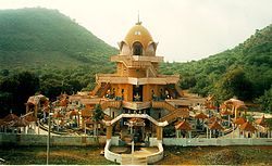 Devipuram temple near Sabbavaram | |
 Sabbavaram Location in Visakhapatnam | |
| Coordinates: 17°47′24″N 83°07′23″E / 17.790°N 83.123°ECoordinates: 17°47′24″N 83°07′23″E / 17.790°N 83.123°E | |
| Country | India |
| State | Andhra Pradesh |
| District | Visakhapatnam |
| Area | |
| • Total | 186.02 km2 (71.82 sq mi) |
| Elevation | 20 m (70 ft) |
| Languages | |
| • Official | Telugu |
| Time zone | UTC+5:30 (IST) |
| Vehicle Registration | AP31 (Former) AP39 (from 30 January 2019)[1] |

Sabbavaram is a town and educational hub of Visakhapatnam in the state of Andhra Pradesh in India.[2] It has three universities:
- Damodaram Sanjivayya National Law University (DSNLU) - website
- Indian Institute of Petroleum and Energy (IIPE) - website
- Indian Maritime University, Visakhapatnam (IMU) - website
Geography[]
Sabbavaram has an average elevation of 20 metres (66 ft).
Villages in Sabbavaram Mandal[]
This section does not cite any sources. (April 2019) |
- BANGARAMMAPALEM
- ADDURU SIRASAPALLE
- RAYAPURA AGRAHARAM
- TEKKALIPALEM
- VANGALI
- ANTAKAPALLE
- AYYANNAPALEM
- ELLUPPI
- BODUVALASA
- GULLEPALLE
- MOGALIPURAM
- SABBAVARAM AGRAHARM
- SABBAVARAM
- GOTIWADA
- GALI BHIMAVARAM
- LAGISETTIPALEM
- ARIPAKA
- NALLAREGULAPALEM
- NARAPADU
- D.SITARAMPURAM
- BATAJANGALAPALEM
- PYDIVADA AGRAHARAM
- PYDIVADA
- ERUKUNAIDUPALEM
- ASAKAPALLE
- IRUVADA
- AMRUTAPURAM
- THAVVAVANI PALEM
- CHINTAGATLA AGRAHARAM
- VIPPAKA AGRAHARAM
- GOLLALAPALEM
- NANGINARAPADU
- GANGAVARAM
- VEDULLANARAVA
- AJANAGIRI
References[]
- ^ "New 'AP 39' code to register vehicles in Andhra Pradesh launched". The New Indian Express. Vijayawada. 31 January 2019. Retrieved 9 June 2019.
- ^ "Mandal wise list of villages in Visakhapatnam district" (PDF). Chief Commissioner of Land Administration. National Informatics Centre. Archived from the original (PDF) on 19 March 2015. Retrieved 6 March 2016.
This article about a location in Visakhapatnam is a stub. You can help Wikipedia by . |
Categories:
- Neighbourhoods in Visakhapatnam
- Visakhapatnam district geography stubs