Sacramento Deep Water Ship Channel
Coordinates: 38°07′32″N 121°41′48″W / 38.12547°N 121.69662°W[1]


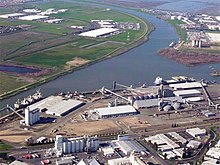
The Sacramento Deep Water Ship Channel (also known as Sacramento River Deep Water Ship Channel or SRDWSC) is a canal from the Port of Sacramento in West Sacramento, California, to the Sacramento River, which flows into San Francisco Bay. It was completed by the United States Army Corps of Engineers in 1963. The channel is about 30 feet (9 m) deep, 200 feet (61 m) wide and 43 miles (69 km) long.
The Port of Sacramento is a significant port on the West Coast of the United States, but receives far less traffic than larger ports. It handles primarily agricultural products and other bulk goods rather than containers, which dominate the shipping market.
A plan to dredge the channel to 35 feet (10 m) became stalled in 1990 because the Port of Sacramento was unable to finance its share of the cost. However, there is still interest in the project.[2]
The channel has one set of ships locks—The William B. Stone Sacramento Locks—located at the eastern terminus of the channel, where it meets the Sacramento River. These locks were decommissioned in the mid 1980s and de-authorized in 2000. While the locks were reactivated for a fish passage study in 2003 and 2004, they are currently non-operational.[3]


History[]
The Sacramento Deep Water Ship Channel was authorized by the River and Harbor Act of 24 July 1946.[4] It is a modification of, and a supplement to, the Sacramento River Shallow Draft Navigation Project which was adopted by the River and Harbor Act of 3 March 1899, which was started in September 1899 and completed in 1904. While the Deep Water Ship Channel project was authorized in 1946, with construction started in 1949, it was stopped in 1950 and did not start again till 1956, with ship operation not until June 1963.[5]
The channel is part of the California Green Trade Corridor project, as ships move cargo much greener than trucks and trains[citation needed]. Green Trade Corridor Marine Highway (ports of Oakland-Stockton-West Sacramento) can improve goods movement through Northern California.[6]
Flora and fauna[]
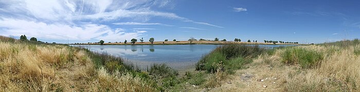
Sea lions have been spotted at the far eastern terminus of the Sacramento Deep Water Ship Channel, at approximately 38°33'04.3"N 121°34'46.6"W,[7] as have American White Pelicans, at approximately 38°33'04.3"N 121°34'46.6"W.[8]
See also[]
- Stockton Deepwater Shipping Channel
- California Heartland
- City of West Sacramento
- United States Army Corps of Engineers
- Container on barge
References[]
- ^ U.S. Geological Survey Geographic Names Information System: Sacramento River Deep Water Ship Channel
- ^ U.S. Army Corps of Engineers: Sacramento River Deep Water Ship Channel Project
- ^ Mayr, Shawn, "Monitoring Flow at the Sacramento Deep Water Ship Channel," California Department of Water Resources - Central District, Feb. 28, 2006. Accessed Dec. 31, 2015.
- ^ USACE 2011, p. 1.
- ^ Sacramento Deep Water Ship Channel, 24 July 1946
- ^ portofoakland.com, California Green Trade Corridor
- ^ [1]
- ^ [2]
| hide | |
|---|---|
| Panamax ports | |
| Non-panamax ports | |
| Canals | |
| Alternate West Coast Seaports |
|
| West Coast LNG Terminals | |
- Canals in California
- Sacramento River
- Geography of the Sacramento Valley
- Bodies of water of Sacramento County, California
- Bodies of water of Solano County, California
- Bodies of water of Yolo County, California
- West Sacramento, California
- Transportation buildings and structures in Sacramento County, California
- Transportation buildings and structures in Solano County, California
- Transportation buildings and structures in Yolo County, California
- Economy of Sacramento, California
- Canals opened in 1963
- 1963 establishments in California
- Geography of the San Francisco Bay Area