Sacred Island of Okinoshima and Associated Sites in the Munakata Region
| UNESCO World Heritage Site | |
|---|---|
| Location | Munakata, Fukuoka Prefecture, Kyushu, Japan |
| Criteria | Cultural: (ii)(iii) |
| Reference | 1535 |
| Inscription | 2017 (41st Session) |
| Area | 98.93 ha (244.5 acres) |
| Buffer zone | 79,363.48 ha (196,111.4 acres) |
| Coordinates | 34°14′42″N 130°6′20″E / 34.24500°N 130.10556°ECoordinates: 34°14′42″N 130°6′20″E / 34.24500°N 130.10556°E |
 Location of Sacred Island of Okinoshima and Associated Sites in the Munakata Region in Japan | |

Sacred Island of Okinoshima and Associated Sites in the Munakata Region (「神宿る島」宗像・沖ノ島と関連遺産群), officially Sacred Island of Okinoshima and Associated Sites in the Munakata Region, is a group of sites in northwest Kyūshū, Japan, that was inscribed on the UNESCO World Heritage List in 2017, under criteria ii and iii.[1]
Background[]
The three Munakata kami are said in the Kojiki and Nihon Shoki to be daughters of Amaterasu, spawned upon the sun-goddess' consumption of giant swords.[2][3] Okitsu-Miya on the island of Okinoshima is part of the Shinto shrine complex of Munakata Taisha; no formal shrine buildings were constructed on the island; instead rock piles or yorishiro provided the focus for veneration.[4] Over 80,000 artefacts were ritually deposited at the site from the fourth to the tenth centuries.[1] These have been designated a National Treasure.[5][6] They include mirrors and bronze dragon-head finials from Wei China; gold rings and horse-trappings similar to those found in Silla tombs in Korea; and fragments of a glass bowl from Sassanian Persia.[2] The (宗像氏), powerful local rulers, controlled the route to the continent and "presided over the rituals".[1][2] The many kofun or tumuli in the area are believed to be their burial ground.[1]
Component Sites[]
| Site | Municipality | Comments | Image | Coordinates |
|---|---|---|---|---|
| Okinoshima 沖ノ島 Okinoshima |
Munakata | the island's primeval forest is a Natural Monument and the island a Wildlife Protection Area[7][8] |  |
34°14′48″N 130°06′15″E / 34.24676121°N 130.10412967°E |
| Munakata Taisha - Okitsu-Miya 宗像神社境内 沖津宮 Munakata Jinja keidai - Okitsumiya |
Munakata | on the island of Okinoshima; Tagori-hime (田心姫神) is enshrined; the precincts of Munakata Taisha are an Historic Site[9] |  |
34°14′29″N 130°06′14″E / 34.241448°N 130.103853°E |
| Munakata Taisha - Nakatsu-Miya 宗像神社境内 中津宮 Munakata Jinja keidai - Nakatsumiya |
Munakata | on the island of Ōshima; Tagitsu-hime (湍津姫神) is enshrined |  |
33°53′49″N 130°25′56″E / 33.896992°N 130.432222°E |
| Munakata Taisha - Hetsu-Miya 宗像神社境内 辺津宮 Munakata Jinja keidai - Hetsumiya |
Munakata | on the mainland of Kyūshū; Ichikishima-hime (市杵島姫神) is enshrined; the ICP honden and haiden date respectively to 1578 and 1590[10][11] | 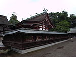 |
33°49′52″N 130°30′52″E / 33.831089°N 130.514347°E |
Original submission[]
The following sites were included in the original nomination, but were excluded from the final inscription:[12][13]
| Site | Municipality | Image | Coordinates |
|---|---|---|---|
| - 津屋崎古墳群 勝浦高原古墳群 Tsuyazaki kofun-gun - Katsuura Takahara kofun-gun |
Fukutsu | 33°50′29″N 130°29′16″E / 33.84132612°N 130.48766519°E | |
| Tsuyazaki Tumulus Cluster - 津屋崎古墳群 勝浦峯ノ畑古墳 Tsuyazaki kofun-gun - Katsuura Minenohata kofun |
Fukutsu | 33°50′15″N 130°29′08″E / 33.837556°N 130.485628°E | |
| Tsuyazaki Tumulus Cluster - 津屋崎古墳群 勝浦井ノ浦古墳 Tsuyazaki kofun-gun - Katsuura Inoura kofun |
Fukutsu | 33°50′16″N 130°29′10″E / 33.837734°N 130.486164°E | |
| Tsuyazaki Tumulus Cluster - 津屋崎古墳群 新原・奴山古墳群 Tsuyazaki kofun-gun - Shinbaru-Nuyama kofun-gun |
Fukutsu |  |
33°48′59″N 130°29′16″E / 33.816379°N 130.487752°E |
| Tsuyazaki Tumulus Cluster - 津屋崎古墳群 生家大塚古墳 Tsuyazaki kofun-gun - Yukue Ōtsuka kofun |
Fukutsu | 33°48′38″N 130°29′02″E / 33.810657°N 130.483868°E | |
| Tsuyazaki Tumulus Cluster - 津屋崎古墳群 大石岡ノ谷古墳群 Tsuyazaki kofun-gun - Ōishi Okanotani kofun |
Fukutsu | 33°48′15″N 130°29′04″E / 33.804149°N 130.484340°E | |
| Tsuyazaki Tumulus Cluster - 津屋崎古墳群 須多田上ノ口古墳 Tsuyazaki kofun-gun - Sudata Kaminokuchi kofun |
Fukutsu | 33°48′11″N 130°29′01″E / 33.802936°N 130.483503°E | |
| Tsuyazaki Tumulus Cluster - 津屋崎古墳群 須多田天降天神社古墳 Tsuyazaki kofun-gun - Sudata Amafurijinja kofun |
Fukutsu | 33°48′12″N 130°28′54″E / 33.803453°N 130.481787°E | |
| Tsuyazaki Tumulus Cluster - 津屋崎古墳群 須多田下ノ口古墳 Tsuyazaki kofun-gun - Sudata Shimonokuchi kofun |
Fukutsu | 33°48′10″N 130°28′54″E / 33.802687°N 130.481744°E | |
| Tsuyazaki Tumulus Cluster - 津屋崎古墳群 須多田ミソ塚古墳 Tsuyazaki kofun-gun - Sudata Misotsuka kofun |
Fukutsu | 33°48′09″N 130°28′50″E / 33.802526°N 130.480435°E | |
| Tsuyazaki Tumulus Cluster - 津屋崎古墳群 須多田ニタ塚古墳 Tsuyazaki kofun-gun - Sudata Nitatsuka kofun |
Fukutsu | 33°48′16″N 130°28′42″E / 33.804398°N 130.478396°E | |
| Tsuyazaki Tumulus Cluster - 津屋崎古墳群 在自剣塚古墳 Tsuyazaki kofun-gun - Araji Tsurugizuka kofun |
Fukutsu | 33°47′47″N 130°29′10″E / 33.796303°N 130.486228°E | |
| Tsuyazaki Tumulus Cluster - 津屋崎古墳群 宮地嶽古墳 Tsuyazaki kofun-gun - Miyajidake kofun |
Fukutsu | 33°46′50″N 130°29′18″E / 33.780645°N 130.488428°E | |
| Tsuyazaki Tumulus Cluster - 津屋崎古墳群 宮司井手ノ上古墳 Tsuyazaki kofun-gun - Miyaji Idenokami kofun |
Fukutsu | 33°46′43″N 130°29′21″E / 33.778657°N 130.489275°E | |
| Tsuyazaki Tumulus Cluster - 津屋崎古墳群 手光波切不動古墳 Tsuyazaki kofun-gun - Tebika Namikirifudō kofun |
Fukutsu | 33°46′18″N 130°29′59″E / 33.771745°N 130.499725°E | |
| Tsuyazaki Tumulus Cluster - 津屋崎古墳群 手光湯ノ浦古墳群 Tsuyazaki kofun-gun - Tebika Yunoura kofun |
Fukutsu | 33°46′43″N 130°29′31″E / 33.778532°N 130.491958°E | |
桜京古墳 Sakurakyō kofun |
Munakata | 33°50′38″N 130°29′43″E / 33.84389006°N 130.4953238°E | |
東郷高塚古墳 Tōgō Takatsuka kofun |
Munakata | 33°47′56″N 130°32′26″E / 33.798889°N 130.540688°E |
See also[]
- List of National Treasures of Japan (archaeological materials)
- Yorishiro
- World Heritage Sites in Japan
References[]
- ^ Jump up to: a b c d "Sacred Island of Okinoshima and Associated Sites in the Munakata Region". UNESCO. Retrieved 10 July 2017.
- ^ Jump up to: a b c Brown, Delmer M, ed. (1993). The Cambridge History of Japan I: Ancient Japan. Cambridge University Press. pp. 312–6. ISBN 0-521-22352-0.
- ^ Aston, W.G. (1972) [1896]. Nihongi: Chronicles of Japan from the Earliest Times to A.D. 697. I. Tuttle. p. 37. ISBN 0-8048-0984-4.
- ^ Watanabe Yasutada (1974). Shinto Art: Ise and Izumo Shrines. Weatherhill. p. 125. ISBN 0-8348-1018-2.
- ^ "福岡県宗像大社沖津宮祭祀遺跡出土品" [Excavated Artefacts from Rites at Munakata Taisha Okitsu-no-Miya] (in Japanese). Agency for Cultural Affairs. Retrieved 28 June 2012.
- ^ "伝福岡県宗像大社沖津宮祭祀遺跡出土品" [Excavated Artefacts attributed to Rites at Munakata Taisha Okitsu-no-Miya] (in Japanese). Agency for Cultural Affairs. Retrieved 28 June 2012.
- ^ "沖の島原始林" [Primeval Forest of Okinoshima] (in Japanese). Agency for Cultural Affairs. Retrieved 28 June 2012.
- ^ "国指定沖ノ島鳥獣保護区" [Okinoshima National Wildlife Protection Area] (in Japanese). Ministry of the Environment. Retrieved 28 June 2012.
- ^ "宗像神社境内" [Munakata Jinja Precinct] (in Japanese). Agency for Cultural Affairs. Retrieved 28 June 2012.
- ^ "宗像神社辺津宮本殿" [Munakata Jinja Hetsumiya Honden] (in Japanese). Agency for Cultural Affairs. Retrieved 28 June 2012.
- ^ "宗像神社辺津宮拝殿" [Munakata Jinja Hetsumiya Haiden] (in Japanese). Agency for Cultural Affairs. Retrieved 28 June 2012.
- ^ "宗像・沖ノ島と関連遺産群" [Okinoshima Island and Related Sites in Munakata Region] (PDF) (in Japanese). World Heritage Promotion Committee of "Okinoshima Island and Related Sites in Munakata Region". pp. 5f. Retrieved 28 June 2012.
- ^ "Okinoshima Island and Related Sites in Munakata Region" (PDF). World Heritage Promotion Committee of "Okinoshima Island and Related Sites in Munakata Region". pp. 6f. Archived from the original (PDF) on 12 December 2013. Retrieved 28 June 2012.
External links[]
- History of Fukuoka Prefecture
- Japanese culture
- World Heritage Sites in Japan