Notification of a Wildlife Protection Area and Special Protection Area in
Yatsu-higata , a
tidal flat and
Ramsar Site in
Tokyo Bay Wildlife Protection Areas (鳥獣保護区 , chōjū hogoku ) in Japan are established by the Ministry of the Environment and, for areas of more local importance, by the Prefectural Governments in order "to protect and promote the reproduction of birds and mammals" in accordance with the 2002 Wildlife Protection and Hunting Law (鳥獣の保護及び狩猟の適正化に関する法律 (superseding the amended 1918 Law).[1] [2] [3] [1] (特別保護地区 ) are designated within the Wildlife Protection Areas in order to protect habitats and ecosystems.[1] [4]
Classification of wildlife [ ] The wildlife of Japan is classified either as game species or protected species.[5] [5] brown bear , black bear , Japanese deer , Japanese hare , Japanese quail , and Japanese pheasant .[4] [4] agriculture ; some marine mammals fall under the alternative jurisdiction of the Ministry of Agriculture, Forestry and Fisheries .[4] [5]
Established Wildlife Protection Areas [ ] As of 1 November 2019, eighty-six Wildlife Protection Areas have been established at a national level, covering an area of 5,930 square kilometres (2,290 sq mi), including 1,639 square kilometres (633 sq mi) of Special Protection Areas.[6] [7] (大規模生息地 ) , wetland areas (集団渡来地 ) , breeding areas (集団繁殖地 ) , and habitats of rare birds and mammals (希少鳥獣生息地 ) , are as follows:[6]
Image
Coordinates
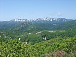
Daisetsuzan 大雪山鳥獣保護区
Hokkaidō 43°39′08″N 142°54′09″E / 43.652224°N 142.902603°E / 43.652224; 142.902603 (Daisetsuzan ) 355.34
1992
1
Towada 十和田鳥獣保護区
Aomori , Akita 40°27′52″N 140°52′40″E / 40.464450°N 140.877686°E / 40.464450; 140.877686 (Towada ) 376.74
1953
1
Shirakami-Sanchi 白神山地鳥獣保護区
Aomori , Akita 40°28′09″N 140°07′50″E / 40.469151°N 140.130444°E / 40.469151; 140.130444 (Shirakami-Sanchi ) 171.57
2004
1
Asama 浅間鳥獣保護区
Gunma , Nagano 36°24′19″N 138°31′20″E / 36.405396°N 138.522320°E / 36.405396; 138.522320 (Asama ) 309.40
1951
1
Hakusan 白山鳥獣保護区
Ishikawa , Gifu 36°09′19″N 136°45′41″E / 36.155237°N 136.761289°E / 36.155237; 136.761289 (Hakusan ) 380.61
1969
1
Ōdai Mountains 大台山系鳥獣保護区
Mie , Nara 34°10′59″N 136°05′01″E / 34.183051°N 136.083612°E / 34.183051; 136.083612 (Ōdai Mountains ) 185.72
1972
1
Tsurugi Mountains 剣山山系鳥獣保護区
Tokushima , Kōchi 33°51′14″N 134°05′41″E / 33.853916°N 134.094787°E / 33.853916; 134.094787 (Tsurugi Mountains ) 118.17
1988
1
Daisen 大山鳥獣保護区
Tottori 35°22′34″N 133°32′40″E / 35.376174°N 133.544312°E / 35.376174; 133.544312 (Daisen ) 51.56
1958
1
Ishizuchi Mountains 石鎚山系鳥獣保護区
Ehime , Kōchi 33°46′18″N 133°06′43″E / 33.771728°N 133.111982°E / 33.771728; 133.111982 (Ishizuchi Mountains ) 108.58
1977
1
Kirishima 霧島鳥獣保護区
Miyazaki , Kagoshima 31°55′00″N 130°52′48″E / 31.916762°N 130.880127°E / 31.916762; 130.880127 (Kirishima ) 114.33
1978
1
Hamatonbetsu Lake Kutcharo 浜頓別クッチャロ湖鳥獣保護区
Hokkaidō 45°08′01″N 142°19′43″E / 45.133739°N 142.328739°E / 45.133739; 142.328739 (Hamatonbetsu Lake Kutcharo ) 28.03
1983
2
Sarobetsu サロベツ鳥獣保護区
Hokkaidō 45°06′20″N 141°41′07″E / 45.105516°N 141.685181°E / 45.105516; 141.685181 (Sarobetsu ) 37.39
1992
2
Lake Tōfutsu 濤沸湖鳥獣保護区
Hokkaidō 43°55′04″N 144°26′15″E / 43.917804°N 144.437599°E / 43.917804; 144.437599 (Lake Tōfutsu ) 20.23
1992
2
Notsuke Peninsula - Notsuke Bay 野付半島・野付湾鳥獣保護区
Hokkaidō 43°37′29″N 145°12′41″E / 43.624768°N 145.211277°E / 43.624768; 145.211277 (Notsuke Peninsula - Notsuke Bay ) 61.46
2005
2
Lake Furen 風蓮湖鳥獣保護区
Hokkaidō 43°20′21″N 145°16′00″E / 43.339162°N 145.266724°E / 43.339162; 145.266724 (Lake Furen ) 81.39
1993
2
Akkeshi --Kiritappu 厚岸・別寒辺牛 ・霧多布鳥獣保護区
Hokkaidō 43°05′01″N 145°04′48″E / 43.083684°N 145.079956°E / 43.083684; 145.079956 (Akkeshi-Bekanbeushi-Kiritappu ) 130.64
1993
2
Miyajima-numa 宮島沼鳥獣保護区
Hokkaidō 43°19′57″N 141°42′49″E / 43.332389°N 141.713719°E / 43.332389; 141.713719 (Miyajima-numa ) 0.41
1992
2
Lake Utonai ウトナイ湖鳥獣保護区
Hokkaidō 42°41′57″N 141°42′43″E / 42.699091°N 141.711831°E / 42.699091; 141.711831 (Lake Utonai ) 5.10
1982
2
Kominato 小湊鳥獣保護区
Aomori 40°56′14″N 140°58′23″E / 40.937118°N 140.973129°E / 40.937118; 140.973129 (Kominato ) 45.18
1971
2
Izu-numa 伊豆沼鳥獣保護区
Miyagi 38°42′55″N 141°06′14″E / 38.715351°N 141.103935°E / 38.715351; 141.103935 (Izu-numa ) 14.55
1982
2
仙台海浜鳥獣保護区
Miyagi 38°12′28″N 140°58′48″E / 38.207702°N 140.979996°E / 38.207702; 140.979996 (Sendai Seaside ) 75.96
1987
2
and the surrounding rice paddies
蕪栗沼 ・周辺水田鳥獣保護区Miyagi 38°38′13″N 141°06′18″E / 38.636919°N 141.105137°E / 38.636919; 141.105137 (Kabukuri-numa ) 30.61
2005
2
化女沼 鳥獣保護区Miyagi 38°37′50″N 140°57′46″E / 38.630550°N 140.962701°E / 38.630550; 140.962701 (Kejo-numa ) 0.78
2008
2
Mogami River Mouth 最上川河口鳥獣保護区
Yamagata 38°55′23″N 139°48′40″E / 38.923159°N 139.811068°E / 38.923159; 139.811068 (Mogami River Mouth ) 15.37
2005
2
大山上池・下池 鳥獣保護区Yamagata 38°45′00″N 139°45′20″E / 38.750134°N 139.755664°E / 38.750134; 139.755664 (Ōyama Kamiike-Shimoike ) 0.39
2008
2
福島潟 鳥獣保護区Niigata 37°54′39″N 139°15′06″E / 37.910922°N 139.251795°E / 37.910922; 139.251795 (Fukushimagata ) 2.31
1974
2
Lake Hyōko 瓢湖鳥獣保護区
Niigata 37°50′19″N 139°14′15″E / 37.838699°N 139.237461°E / 37.838699; 139.237461 (Lake Hyōko ) 2.81
2005
2
佐潟 鳥獣保護区Niigata 37°48′58″N 138°52′27″E / 37.816056°N 138.874054°E / 37.816056; 138.874054 (Sakata ) 2.51
1981
2
涸沼 鳥獣保護区Ibaraki 36°16′30″N 140°30′18″E / 36.274935°N 140.505137°E / 36.274935; 140.505137 (Hinuma ) 20.72
2014
2
渡良瀬遊水地 鳥獣保護区Ibaraki , Tochigi , Gunma , Saitama 36°14′20″N 139°42′00″E / 36.238874°N 139.699917°E / 36.238874; 139.699917 (Watarase Reservoir ) 28.61
2012
2
Kasaioki -葛西沖三枚洲 鳥獣保護区Tokyo 35°38′01″N 139°51′48″E / 35.633728°N 139.863213°E / 35.633728; 139.863213 (Kasaioki-Sanmaisu ) 3.80
2018
2
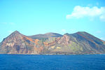
Yatsu 谷津鳥獣保護区
Chiba 35°40′39″N 140°00′28″E / 35.677413°N 140.007813°E / 35.677413; 140.007813 (Yatsu ) 0.41
1988
2
片野鴨池 鳥獣保護区Ishikawa 36°19′18″N 136°17′39″E / 36.321669°N 136.294069°E / 36.321669; 136.294069 (Katano Kamoike ) 0.10
1993
2
Fujimae-higata 藤前干潟鳥獣保護区
Aichi 35°04′54″N 136°50′15″E / 35.081638°N 136.837635°E / 35.081638; 136.837635 (Fujimae-higata ) 7.70
2002
2
浜甲子園鳥獣保護区
Hyōgo 34°42′54″N 135°21′03″E / 34.714895°N 135.350704°E / 34.714895; 135.350704 (Hamakōshien ) 0.30
1978
2
Nakaumi 中海鳥獣保護区
Tottori , Shimane 35°28′01″N 133°11′39″E / 35.466822°N 133.194122°E / 35.466822; 133.194122 (Nakaumi ) 86.82
1974
2
Lake Shinji 宍道湖鳥獣保護区
Shimane 35°27′48″N 133°02′59″E / 35.463466°N 133.049669°E / 35.463466; 133.049669 (Lake Shinji ) 78.99
2005
2
-
和白干潟 ・多々良川 河口鳥獣保護区Fukuoka 33°41′12″N 130°25′46″E / 33.686639°N 130.429516°E / 33.686639; 130.429516 (Wajiro-higata - Tatara River Mouth ) 2.91
2003
2
東よか干潟 鳥獣保護区Saga 33°10′25″N 130°16′13″E / 33.173684°N 130.270223°E / 33.173684; 130.270223 (Higashiyoka-higata ) 2.39
2015
2
Hizen 肥前鹿島干潟鳥獣保護区
Saga 33°06′32″N 130°07′41″E / 33.108999°N 130.128189°E / 33.108999; 130.128189 (Hizen Kashima-higata ) 0.67
2015
2
荒尾干潟 鳥獣保護区Kumamoto 32°59′11″N 130°25′45″E / 32.986456°N 130.429215°E / 32.986456; 130.429215 (Arao-higata ) 18.23
2012
2
Izumi -Takaono 出水・高尾野鳥獣保護区
Kagoshima 32°06′12″N 130°16′27″E / 32.103226°N 130.274162°E / 32.103226; 130.274162 (Izumi-Takaono ) 8.42
1987
2
屋我地 鳥獣保護区Okinawa 26°38′54″N 128°01′59″E / 26.648255°N 128.033187°E / 26.648255; 128.033187 (Yagaji ) 32.17
1976
2
Lake Man 漫湖鳥獣保護区
Okinawa 43°55′04″N 144°26′15″E / 43.917804°N 144.437599°E / 43.917804; 144.437599 (Lake Man ) 1.74
1977
2
与那覇湾 鳥獣保護区Okinawa 24°45′34″N 125°15′47″E / 24.759517°N 125.263174°E / 24.759517; 125.263174 (Yonaha Bay ) 13.66
2011
2
Ikema 池間鳥獣保護区
Okinawa 24°55′56″N 125°14′31″E / 24.932171°N 125.241909°E / 24.932171; 125.241909 (Ikema ) 2.82
2011
2
Teuri Island 天売島鳥獣保護区
Hokkaidō 44°25′18″N 141°18′32″E / 44.421705°N 141.308813°E / 44.421705; 141.308813 (Teuri Island ) 5.51
1982
3
-
ユルリ ・モユルリ 鳥獣保護区Hokkaidō 43°13′37″N 145°36′27″E / 43.226991°N 145.607600°E / 43.226991; 145.607600 (Yururi-Moyururi ) 1.99
1982
3
Daikoku Island 大黒島鳥獣保護区
Hokkaidō 42°57′17″N 144°52′24″E / 42.954664°N 144.873276°E / 42.954664; 144.873276 (Daikoku Island ) 1.07
1972
3
Hide Island 日出島鳥獣保護区
Iwate 39°41′14″N 141°59′16″E / 39.687152°N 141.987648°E / 39.687152; 141.987648 (Hide Island ) 0.08
1982
3
三貫島 鳥獣保護区Iwate 39°18′21″N 141°58′57″E / 39.305878°N 141.982498°E / 39.305878; 141.982498 (Sangan Island ) 0.25
1981
3
祗苗島鳥獣保護区
Tokyo 34°12′28″N 139°11′30″E / 34.207685°N 139.191713°E / 34.207685; 139.191713 (Tadanae-jima ) 5.93
2010
3
Ōnohara-jima 大野原島鳥獣保護区
Tokyo 34°02′41″N 139°23′15″E / 34.044722°N 139.3875°E / 34.044722; 139.3875 (Ōnohara-jima ) 5.46
2010
3
Nishinoshima 西之島鳥獣保護区
Tokyo 27°14′49″N 140°52′28″E / 27.246944°N 140.874444°E / 27.246944; 140.874444 (Nishinoshima ) 0.29
2008
3
North Iwo Jima 北硫黄島鳥獣保護区
Tokyo 25°26′17″N 141°16′59″E / 25.438082°N 141.282978°E / 25.438082; 141.282978 (North Iwo Jima ) 8.60
2009
3
Minamitorishima 南鳥島鳥獣保護区
Tokyo 24°16′59″N 153°59′11″E / 24.283056°N 153.986389°E / 24.283056; 153.986389 (Minamitorishima ) 3.95
2009
3
Nanatsu-jima 七ツ島鳥獣保護区
Ishikawa 37°36′35″N 136°54′05″E / 37.609722°N 136.901389°E / 37.609722; 136.901389 (Nanatsu-jima ) 0.24
1973
3
Kiinagashima 紀伊長島鳥獣保護区
Mie 34°11′52″N 136°19′45″E / 34.197818°N 136.329045°E / 34.197818; 136.329045 (Kiinagashima ) 61.31
1969
3
Kanmurijima - Kutsujima 冠島・沓島鳥獣保護区
Kyoto 35°40′53″N 135°25′28″E / 35.681370°N 135.424433°E / 35.681370; 135.424433 (Kanmurijima - Kutsujima ) 13.00
2010
3
鹿久居島 鳥獣保護区Okayama 34°43′10″N 134°18′20″E / 34.719444°N 134.305556°E / 34.719444; 134.305556 (Kakui Island ) 6.62
1953
3
Okinoshima 沖ノ島鳥獣保護区
Fukuoka 34°14′40″N 130°06′15″E / 34.244411°N 130.104046°E / 34.244411; 130.104046 (Okinoshima ) 0.97
1984
3
Danjo Islands 男女群島 鳥獣保護区Nagasaki 31°59′20″N 128°21′07″E / 31.988889°N 128.351944°E / 31.988889; 128.351944 (Danjo Islands ) 4.16
1973
3
Birōjima 枇榔島鳥獣保護区
Miyazaki 32°27′54″N 131°43′51″E / 32.464911°N 131.730795°E / 32.464911; 131.730795 (Birōjima ) 4.82
2010
3
Kusagaki-jima 草垣島鳥獣保護区
Kagoshima 30°50′32″N 129°26′01″E / 30.842184°N 129.433665°E / 30.842184; 129.433665 (Kusagaki-jima ) 0.21
1973
3
仲の神島 鳥獣保護区Okinawa 24°11′42″N 123°33′50″E / 24.195°N 123.563889°E / 24.195; 123.563889 (Nakanokami Island ) 0.18
1981
3
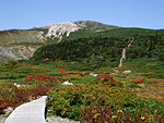
Shiretoko 知床鳥獣保護区
Hokkaidō 44°03′17″N 145°06′14″E / 44.054778°N 145.103989°E / 44.054778; 145.103989 (Shiretoko ) 440.53
1982
4
Kushiro Shitsugen 釧路湿原鳥獣保護区
Hokkaidō 43°03′59″N 144°17′49″E / 43.066254°N 144.297009°E / 43.066254; 144.297009 (Kushiro Shitsugen ) 172.41
1958
4
Western Shimokita 下北西部鳥獣保護区
Aomori 41°18′52″N 141°05′21″E / 41.314434°N 141.089172°E / 41.314434; 141.089172 (Western Shimokita ) 49.14
1984
4
Hotokenuma 仏沼鳥獣保護区
Aomori 40°48′55″N 141°22′52″E / 40.815303°N 141.381083°E / 40.815303; 141.381083 (Hotokenuma ) 7.37
2005
4
Ōgata 大潟草原鳥獣保護区
Akita 40°00′56″N 139°57′08″E / 40.015520°N 139.952259°E / 40.015520; 139.952259 (Ōgata Grasslands ) 1.50
1977
4
森吉山 鳥獣保護区Akita 39°58′35″N 140°32′40″E / 39.976265°N 140.544577°E / 39.976265; 140.544577 (Mount Moriyoshi ) 65.98
1973
4
Ōshima Asahi 大鳥朝日鳥獣保護区
Yamagata , Niigata 38°15′38″N 139°55′20″E / 38.260592°N 139.922261°E / 38.260592; 139.922261 (Ōshima Asahi ) 382.85
1984
4
Tori-shima 鳥島鳥獣保護区
Tokyo 30°29′02″N 140°18′11″E / 30.483889°N 140.303056°E / 30.483889; 140.303056 (Tori-shima ) 4.79
1954
4
Ogasawara 小笠原群島鳥獣保護区
Tokyo 27°06′32″N 142°12′14″E / 27.108798°N 142.203941°E / 27.108798; 142.203941 (Ogasawara ) 200.65
1980
4
Eastern Sado 小佐渡東部鳥獣保護区
Niigata 38°03′55″N 138°26′14″E / 38.065392°N 138.437347°E / 38.065392; 138.437347 (Eastern Sado ) 129.19
1982
4
Northern Alps 北アルプス鳥獣保護区
Toyama , Nagano , Gifu 36°16′19″N 137°38′12″E / 36.271957°N 137.636719°E / 36.271957; 137.636719 (Northern Alps ) 1,099.89
1984
4
Maruyama River Basin円山川下流域鳥獣保護区
Hyōgo 35°38′45″N 134°49′49″E / 35.645788°N 134.830399°E / 35.645788; 134.830399 (Maruyama River Basin ) 10.84
2012
4
Ina 伊奈鳥獣保護区
Nagasaki 34°36′22″N 129°25′08″E / 34.606085°N 129.418945°E / 34.606085; 129.418945 (Ina ) 11.73
1988
4
舟志ノ内鳥獣保護区
Nagasaki 34°35′59″N 129°26′08″E / 34.599725°N 129.435616°E / 34.599725; 129.435616 (Shūshinouchi ) 3.40
2015
4
湯湾岳鳥獣保護区
Kagoshima 31°44′18″N 130°38′51″E / 31.738387°N 130.647440°E / 31.738387; 130.647440 (Mount Yuwan ) 3.20
1965
4
名蔵アンパル 鳥獣保護区Okinawa 24°22′50″N 124°07′56″E / 24.380522°N 124.132161°E / 24.380522; 124.132161 (Nagura-Anparu ) 11.45
2003
4
Yanbaru (Ada)やんばる(安田)鳥獣保護区
Okinawa 26°45′10″N 128°19′32″E / 26.752700°N 128.325419°E / 26.752700; 128.325419 (Yanbaru (Ada) ) 12.79
2009
4
Yanbaru (Aha)やんばる(安波)鳥獣保護区
Okinawa 26°42′59″N 128°15′55″E / 26.716404°N 128.265209°E / 26.716404; 128.265209 (Yanbaru (Aha) ) 4.65
2009
4
Daitō Islands 大東諸島鳥獣保護区
Okinawa 25°51′26″N 131°14′18″E / 25.857293°N 131.238470°E / 25.857293; 131.238470 (Daitō Islands ) 42.51
2004
4
Yonaguni 与那国鳥獣保護区
Okinawa 24°26′59″N 122°58′27″E / 24.449650°N 122.974262°E / 24.449650; 122.974262 (Yonaguni ) 10.40
2010
4
Iriomote 西表鳥獣保護区
Okinawa 24°20′29″N 123°49′26″E / 24.341466°N 123.823814°E / 24.341466; 123.823814 (Iriomote ) 102.18
1992
4
This list is complete and up to date as of April 2021 .
Complementary measures [ ] Wildlife Protection Areas are just one element in a network of complementary protected area systems.[8] Wilderness Areas and Nature Conservation Areas under the Nature Conservation Law; Natural Parks under the Natural Parks Law; Natural Habitat Conservation Areas under the Law for the Conservation of Endangered Species of Wild Fauna and Flora; Natural Monuments and Special Natural Monuments under the Law for the Protection of Cultural Properties 1950 ; Protected Forests under the National Forest Management Bylaw; and under the Preservation of Fisheries Resources Law.[8] World Heritage Convention (see Yakushima , Shirakami-Sanchi , Shiretoko , and Ogasawara Islands ); Man and the Biosphere Programme (see Yakushima , Mount Ōmine /Mount Ōdaigahara , Hakusan , and Shiga Kōgen ); and the Ramsar Convention (see Ramsar Sites in Japan ).[8]
See also [ ] References [ ] External links [ ]