Areas of national forest in Japan
Protected Forests (保護林 , Hogo-rin ) are areas of national forest in Japan so designated in an effort to conserve biodiversity . Japan's Protected Forest system includes three categories of protected forests: Forest Biosphere Reserves; Biotic Community Protection Forests; and Rare Population Protection Forests. Some of these national forests are linked by a network of Green Corridors that are also included in the system. Established in 1915, the system was overhauled in 2015 and expanded in 2019.
Background [ ] Forests cover approximately two-thirds of Japan, extending over some 25,000,000 hectares (62,000,000 acres); of this, according to the Forestry Agency (林野庁 , c.54% is classed as "natural forest", "planted forest" comprising most of the remainder.[1] (ja represent 30%, with the remaining 12% otherwise publicly owned, by prefectural and municipal governments, etc.[1]
Forest conservation measures have a long history in the country: according to the Yōrō Code of 718, "the benefits of mountain, river, grove, and marsh are for government and people alike", with two clauses prohibiting cultivation in the mountains and encouraging the planting of trees along riverbanks and beside dams to counter erosion, while in Kasugayama Primeval Forest (春日山原始林 in Nara , tree-felling and hunting have been forbidden since 841.[2] [3]
Currently, forests are protected under a number of different systems and laws: as Natural Parks under the Natural Parks Act, Nature Conservation Areas under the Nature Conservation Act, Wildlife Protection Areas under the Wildlife Protection and Hunting Management Act, Natural Habitat Conservation Areas under the Conservation of Endangered Species of Wild Fauna and Flora Act, Special Seed Tree Forests (特別母樹林 ) under the Forestry Seeds and Seedlings Act (林業種苗法 ) , Historic Sites, Places of Scenic Beauty, and Natural Monuments under the Law for the Protection of Cultural Properties —and as Protected Forests and Green Corridors.[1] [4]
Protected Forests date back to an ordinance of Taishō 4 (1915), with the first such forest established the following year, in Kamikōchi .[5] [6] [5] [5] [5] [5] (森林・林業基本法 was fully revised in line with international trends towards sustainability; the nation's basic forestry strategy and management plan are developed in accordance with this Act.[1] [5]
In 2015, a century after their institution, the Protected Forest system was revised, with the categories reduced from seven to three: (1) Forest Biosphere Reserve; (2) Biotic Community Protection Forest; and (3) Rare Population Protection Forest.[1] [7] [note 1] [8] [9] [1] [10]
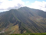
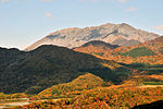
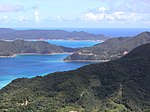
Protected Forests [ ] Forest Biosphere Reserves [ ] As of 1 April 2018, 31 Forest Biosphere Reserves (森林生態系保護地域 ) have been designated, covering an area of 701,000 hectares (1,730,000 acres).[8] UNESCO World Heritage List as Natural World Heritage Sites : Shiretoko , Shirakami-Sanchi , Ogaswara Islands , and Yakushima , while Amami Islands , Yanbaru , and Iriomote have been nominated for joint inscription and are currently on the Tentative List .[8] [11]
Image
Coordinates
Ref.
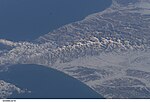
Shiretoko 知床森林生態系保護地域
Hokkaidō 459.89
44°20′09″N 145°19′49″E / 44.3359°N 145.3302°E / 44.3359; 145.3302 (Shiretoko ) [1]
Source
狩場山 地須築川源流部森林生態系保護地域Hokkaidō 27.32
42°36′43″N 139°56′15″E / 42.6119°N 139.9374°E / 42.6119; 139.9374 (Kariba-sanchi Sukki River Source ) [2]
Taisetsuzan 大雪山森林生態系保護地域
Hokkaidō 961.97
43°35′28″N 142°53′40″E / 43.5910°N 142.8944°E / 43.5910; 142.8944 (Taisetsuzan ) [3]
Hidaka Mountains 日高山脈森林生態系保護地域
Hokkaidō 1679.68
42°43′10″N 142°40′58″E / 42.7195°N 142.6828°E / 42.7195; 142.6828 (Hidaka Mountains ) [4]
Izari-dake Environs漁岳 周辺森林生態系保護地域Hokkaidō 32.67
42°49′24″N 141°13′41″E / 42.8233°N 141.2281°E / 42.8233; 141.2281 (Mount Izari ) [5]
Shirakami-Sanchi 白神山地森林生態系保護地域
Aomori , Akita 169.71
40°30′13″N 140°01′07″E / 40.5037°N 140.0187°E / 40.5037; 140.0187 (Shirakami-Sanchi ) [6]
Osore-zan Mountains 恐山山地森林生態系保護地域
Aomori 55.38
41°18′29″N 141°05′15″E / 41.3081°N 141.0874°E / 41.3081; 141.0874 (Osore-zan Mountains ) [7]
Mount Hayachine Environs早池峰山周辺森林生態系保護地域
Iwate 81.45
39°33′30″N 141°29′16″E / 39.5583°N 141.4879°E / 39.5583; 141.4879 (Mount Hayachine Environs ) [8]
– Source
葛根田川・玉川 源流部森林生態系保護地域
Iwate 93.91
39°54′07″N 140°41′40″E / 39.9020°N 140.6945°E / 39.9020; 140.6945 (Kakkonda River–Tama River Source ) [9]
– Environs
栗駒山 ・栃ヶ森山周辺森林生態系保護地域Iwate , Miyagi , Akita 163.34
38°57′39″N 140°47′18″E / 38.9608°N 140.7883°E / 38.9608; 140.7883 (Mount Kurikoma–Mount Tochigamori ) [10]
朝日山地 森林生態系保護地域Yamagata , Niigata 605.22
38°15′39″N 139°55′16″E / 38.2607°N 139.9210°E / 38.2607; 139.9210 (Asahi Mountains ) [11]
Mount Iide Environs飯豊山周辺森林生態系保護地域
Yamagata , Fukushima , Niigata 294.45
38°15′39″N 139°55′16″E / 38.2607°N 139.9210°E / 38.2607; 139.9210 (Mount Iide Environs ) [12]
Mount Azuma Environs吾妻山 周辺森林生態系保護地域Fukushima 81.98
37°44′19″N 140°08′25″E / 37.7386°N 140.1403°E / 37.7386; 140.1403 (Mount Azuma Environs ) [13]
奥会津 森林生態系保護地域Fukushima 839.92
37°27′36″N 139°33′32″E / 37.4601°N 139.5589°E / 37.4601; 139.5589 (Oku-Aizu ) [14]
Ogaswara Islands 小笠原諸島森林生態系保護地域
Tōkyō 55.79
26°40′26″N 142°09′13″E / 26.6738°N 142.1536°E / 26.6738; 142.1536 (Ogaswara Islands ) [15]
Tone River Source–Hiuchigatake Environs利根川源流部・燧ヶ岳周辺森林生態系保護地域
Niigata , Gunma 200.86
36°58′15″N 139°02′36″E / 36.9708°N 139.0432°E / 36.9708; 139.0432 (Tone River Source–Hiuchigatake Environs ) [16]
Environs
佐武流山 周辺森林生態系保護地域Niigata , Nagano 127.92
36°46′20″N 138°40′15″E / 36.7721°N 138.6708°E / 36.7721; 138.6708 (Mount Saburyū Environs ) [17]
Hakusan 白山森林生態系保護地域
Ishikawa , Gifu 149.14
36°09′50″N 136°46′22″E / 36.1640°N 136.7728°E / 36.1640; 136.7728 (Hakusan ) [18]
Northern Alps (– Source)北アルプス(金木戸川・高瀬川源流部)森林生態系保護地域
Nagano , Gifu 80.99
36°26′46″N 137°44′01″E / 36.4462°N 137.7336°E / 36.4462; 137.7336 (Northern Alps (Kanakido River–Takase River Source) ) [19]
Central Alps Mount Kisokoma 中央アルプス木曽駒ケ岳森林生態系保護地域
Nagano 18.13
35°47′22″N 137°48′16″E / 35.7895°N 137.8044°E / 35.7895; 137.8044 (Central Alps Mount Kisokoma ) [20]
Southern Minami-Alps Mount Tekari 南アルプス南部光岳森林生態系保護地域
Nagano , Shizuoka 47.59
35°20′17″N 138°05′02″E / 35.3381°N 138.0839°E / 35.3381; 138.0839 (Southern Minami-Alps Mount Tekari ) [21]
大杉谷 森林生態系保護地域Mie 13.91
34°12′40″N 136°09′03″E / 34.2110°N 136.1507°E / 34.2110; 136.1507 (Ōsugidani ) [22]
Daisen 大山森林生態系保護地域
Tottori 31.90
35°22′41″N 133°32′59″E / 35.3781°N 133.5496°E / 35.3781; 133.5496 (Daisen ) [23]
石鎚山系 森林生態系保護地域Ehime 33°46′06″N 133°06′51″E / 33.7683°N 133.1143°E / 33.7683; 133.1143 (Ishizuchi Mountains ) [24]
Mount Sobo ––Mount Ōkue Environs祖母山・傾山 ・大崩山周辺森林生態系保護地域
Ōita , Miyazaki 59.78
32°49′40″N 131°20′50″E / 32.8279°N 131.3473°E / 32.8279; 131.3473 (Mount Sobo–Mount Katamuki–Mount Ōkue Environs ) [25]
綾森林生態系保護地域
Miyazaki 14.85
32°01′47″N 131°10′17″E / 32.0297°N 131.1715°E / 32.0297; 131.1715 (Aya ) [26]
Environs
稲尾岳 周辺森林生態系保護地域Kagoshima 10.45
31°07′28″N 130°53′10″E / 31.1244°N 130.8862°E / 31.1244; 130.8862 (Mount Inao Environs ) [27]
Yakushima 屋久島森林生態系保護地域
Kagoshima 151.85
30°20′29″N 130°30′42″E / 30.3414°N 130.5117°E / 30.3414; 130.5117 (Yakushima ) [28]
Amami Islands 奄美群島森林生態系保護地域
Kagoshima 48.20
28°15′38″N 129°21′58″E / 28.2606°N 129.3662°E / 28.2606; 129.3662 (Amami Islands ) [29]
Yanbaru やんばる森林生態系保護地域
Okinawa 30.07
26°38′15″N 128°08′02″E / 26.6376°N 128.1339°E / 26.6376; 128.1339 (Yanbaru ) [30]
Iriomote 西表島森林生態系保護地域
Okinawa 204.71
24°19′48″N 123°49′19″E / 24.3301°N 123.8219°E / 24.3301; 123.8219 (Iriomote ) [31]
This list is complete and up to date as of April 2021 .
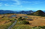
[ ] As of 1 April 2018, 95 Biotic Community Protection Forests (生物群集保護林 ) have been designated, covering an area of 236,000 hectares (580,000 acres).[8]
Image
Coordinates
Ref.
Environs
無意根山 周辺生物群集保護林Hokkaidō 20.47
42°55′52″N 141°02′28″E / 42.9311°N 141.0411°E / 42.9311; 141.0411 (Mount Muine Environs ) [32]
Mount Yūbari 夕張岳生物群集保護林
Hokkaidō 14.49
43°06′00″N 142°15′04″E / 43.0999°N 142.2512°E / 43.0999; 142.2512 (Mount Yūbari ) [33]
知駒生物群集保護林
Hokkaidō 12.33
44°57′31″N 142°09′03″E / 44.9587°N 142.1508°E / 44.9587; 142.1508 (Shirikoma ) [34]
稚咲内生物群集保護林
Hokkaidō 20.18
45°04′56″N 141°38′41″E / 45.0822°N 141.6448°E / 45.0822; 141.6448 (Wakasakanai ) [35]
Lake Kutcharo クッチャロ湖生物群集保護林
Hokkaidō 3.84
45°08′12″N 142°19′37″E / 45.1368°N 142.3269°E / 45.1368; 142.3269 (Lake Kutcharo ) [36]
Rishiri Island 利尻島生物群集保護林
Hokkaidō 44.46
45°11′11″N 141°14′27″E / 45.1863°N 141.2409°E / 45.1863; 141.2409 (Rishiri Island ) [37]
Rebun Island 礼文島生物群集保護林
Hokkaidō 23.91
45°23′43″N 140°59′14″E / 45.3952°N 140.9873°E / 45.3952; 140.9873 (Rebun Island ) [38]
Taisetsu Primeval Forest大雪原生林生物群集保護林
Hokkaidō 5.27
43°32′09″N 142°59′20″E / 43.5359°N 142.9889°E / 43.5359; 142.9889 (Taisetsu Primeval Forest ) [39]
Taisetsu Mountain Range Alpine Zone大雪山系高山帯生林生物群集保護林
Hokkaidō 13.40
43°42′58″N 142°50′38″E / 43.7162°N 142.8440°E / 43.7162; 142.8440 (Taisetsu Mountain Range Alpine Zone ) [40]
Mount Shari 斜里岳生林生物群集保護林
Hokkaidō 23.53
43°45′49″N 144°42′53″E / 43.7635°N 144.7147°E / 43.7635; 144.7147 (Mount Shari ) [41]
Mount Unabetsu 海別岳生林生物群集保護林
Hokkaidō 26.96
43°52′37″N 144°52′34″E / 43.8769°N 144.8762°E / 43.8769; 144.8762 (Mount Unabetsu ) [42]
別寒辺牛 生林生物群集保護林Hokkaidō 24.12
43°06′08″N 144°50′54″E / 43.1023°N 144.8482°E / 43.1023; 144.8482 (Bekanbeushi ) [43]
Mount Oakan 雄阿寒岳生林生物群集保護林
Hokkaidō 37.59
43°27′14″N 144°09′53″E / 43.4540°N 144.1646°E / 43.4540; 144.1646 (Mount Oakan ) [44]
Notsuke Peninsula 野付半島生林生物群集保護林
Hokkaidō 3.01
43°36′12″N 145°16′08″E / 43.6034°N 145.2688°E / 43.6034; 145.2688 (Notsuke Peninsula ) [45]
大平山生林生物群集保護林
Hokkaidō 5.11
42°38′14″N 140°08′10″E / 42.6373°N 140.1362°E / 42.6373; 140.1362 (Mount Obira ) [46]
Mount Sengen 千軒岳生林生物群集保護林
Hokkaidō 9.58
41°34′45″N 140°09′39″E / 41.5793°N 140.1609°E / 41.5793; 140.1609 (Mount Sengen ) [47]
鶉川生林生物群集保護林
Hokkaidō 5.11
41°57′07″N 140°20′00″E / 41.9519°N 140.3333°E / 41.9519; 140.3333 (Uzura River ) [48]
椴川生林生物群集保護林
Hokkaidō 4.99
41°48′13″N 140°09′05″E / 41.8037°N 140.1515°E / 41.8037; 140.1515 (Todo River ) [49]
Okushiri Island 奥尻島生物群集保護林
Hokkaidō 22.85
42°09′25″N 139°27′24″E / 42.1569°N 139.4566°E / 42.1569; 139.4566 (Okushiri Island ) [50]
Hakkōda Mountains 八甲田山生物群集保護林
Aomori 64.10
40°39′53″N 140°54′44″E / 40.6648°N 140.9122°E / 40.6648; 140.9122 (Mount Hakkōda ) [51]
Hachimantai 八幡平生物群集保護林
Iwate , Akita 102.35
39°57′22″N 140°51′10″E / 39.9562°N 140.8529°E / 39.9562; 140.8529 (Hachimantai ) [52]
五葉山 生物群集保護林Iwate 102.35
39°12′14″N 141°43′43″E / 39.2040°N 141.7287°E / 39.2040; 141.7287 (Mount Goyō ) [53]
和賀岳 生物群集保護林Iwate , Akita 89.55
39°34′14″N 140°45′15″E / 39.5706°N 140.7543°E / 39.5706; 140.7543 (Mount Waga ) [54]
Mount Yakeishi 焼石岳生物群集保護林
Iwate 87.68
39°09′49″N 140°49′41″E / 39.1636°N 140.8281°E / 39.1636; 140.8281 (Mount Yakeishi ) [55]
毒ヶ森 生物群集保護林Iwate 16.39
39°38′08″N 141°02′32″E / 39.6355°N 141.0421°E / 39.6355; 141.0421 (Busugamori ) [56]
Mount Funagata (Mount Goshō) 船形山(御所山)生物群集保護林
Miyagi , Yamagata 71.51
38°27′18″N 140°37′11″E / 38.4551°N 140.6196°E / 38.4551; 140.6196 (Mount Funagata (Mount Goshō) ) [57]
Zaō 蔵王生物群集保護林
Miyagi , Yamagata 66.21
38°09′11″N 140°26′46″E / 38.1531°N 140.4460°E / 38.1531; 140.4460 (Zaō ) [58]
太平山 生物群集保護林Akita 72.23
39°47′50″N 140°18′38″E / 39.7971°N 140.3106°E / 39.7971; 140.3106 (Mount Taihei ) [59]
–
番鳥森・大仏岳生物群集保護林
Akita 12.39
39°48′50″N 140°30′57″E / 39.8138°N 140.5158°E / 39.8138; 140.5158 (Bandori Forest–Mount Daibutsu ) [60]
Northwest Ōu Mountains 奥羽山脈北西部生物群集保護林
Akita 11.91
39°58′38″N 140°32′39″E / 39.9772°N 140.5443°E / 39.9772; 140.5443 (Northwest Ōu Mountains ) [61]
Oga Peninsula Coastal Life男鹿半島海岸植生生物群集保護林
Akita 6.55
39°57′10″N 139°43′38″E / 39.9527°N 139.7272°E / 39.9527; 139.7272 (Oga Peninsula Coastal Life ) [62]
葡萄森生物群集保護林
Akita 5.79
39°52′00″N 140°36′44″E / 39.8668°N 140.6121°E / 39.8668; 140.6121 (Budōmori ) [63]
Mount Chōkai 鳥海山生物群集保護林
Akita , Yamagata 72.41
39°05′56″N 140°02′39″E / 39.0989°N 140.0442°E / 39.0989; 140.0442 (Mount Chōkai ) [64]
Gassan 月山生物群集保護林
Yamagata 68.22
38°32′59″N 140°01′37″E / 38.5496°N 140.0269°E / 38.5496; 140.0269 (Gassan ) [65]
–
栂峰・飯森山生物群集保護林
Yamagata 10.43
37°49′42″N 139°56′14″E / 37.8284°N 139.9373°E / 37.8284; 139.9373 (Tsugamine–Mount Iimori ) [66]
–
甲子・二岐山 生物群集保護林
Fukushima 31.00
37°14′47″N 139°58′02″E / 37.2465°N 139.9673°E / 37.2465; 139.9673 (Kashi–Mount Futamata ) [67]
阿武隈高地 生物群集保護林Fukushima 11.90
37°17′N 140°43′E / 37.29°N 140.72°E / 37.29; 140.72 (Abukuma Plateau ) [68]
Oku-Kinu 奥鬼怒 生物群集保護林Tochigi 25.85
36°49′N 139°43′E / 36.82°N 139.71°E / 36.82; 139.71 (Oku-Kinu ) [69]
大佐飛山地 生物群集保護林Tochigi 81.52
37°03′49″N 139°50′40″E / 37.0635°N 139.8444°E / 37.0635; 139.8444 (Ōsabi Mountains ) [70]
尚仁沢 生物群集保護林Tochigi 6.16
36°51′35″N 139°49′13″E / 36.8597°N 139.8202°E / 36.8597; 139.8202 (Shōjinsawa ) [71]
上野楢原のシオジ 等生物群集保護林
Gunma 3.03
36°04′N 138°42′E / 36.06°N 138.70°E / 36.06; 138.70 (Ueno Narahara Fraxinus platypoda ) [72]
秩父山地 生物群集保護林Saitama 21.45
35°56′34″N 138°44′05″E / 35.9429°N 138.7346°E / 35.9429; 138.7346 (Chichibu Mountains ) [73]
Tanzawa Mountains 丹沢山地生物群集保護林
Kanagawa 8.81
35°29′N 139°06′E / 35.48°N 139.10°E / 35.48; 139.10 (Tanzawa Mountains ) [74]
小松原湿原生物群集保護林
Niigata 14.99
36°53′09″N 138°40′34″E / 36.8859°N 138.6762°E / 36.8859; 138.6762 (Komatsubara Wetlands ) [75]
守門岳 生物群集保護林Niigata 17.78
37°23′52″N 139°08′11″E / 37.3979°N 139.1365°E / 37.3979; 139.1365 (Mount Sumon ) [76]
Echigo Mountains 越後山脈 生物群集保護林Niigata 20.09
37°31′17″N 139°25′33″E / 37.5214°N 139.4257°E / 37.5214; 139.4257 (Echigo Mountains ) [77]
カヤの平 等等生物群集保護林Niigata 14.00
36°52′24″N 138°40′25″E / 36.8734°N 138.6735°E / 36.8734; 138.6735 (Kaya no Daira ) [78]
Northern Alps (–)北アルプス(朝日 ・白馬 連山)生物群集保護林
Toyama , Nagano 60.76
36°49′36″N 137°43′48″E / 36.8266°N 137.7299°E / 36.8266; 137.7299 (Northern Alps (Mount Asahi–Hakuba Mountains) ) [79]
Northern Alps (Kurobe –––)北アルプス(黒部・五竜 ・針ノ木 ・白沢天狗)生物群集保護林
Toyama , Nagano 107.53
36°32′17″N 137°41′03″E / 36.5381°N 137.6842°E / 36.5381; 137.6842 (Northern Alps (Kurobe–Goryū–Harinoki–Shirasawa Tengu) ) [80]
Source
犀川 源流生物群集保護林Ishikawa 17.94
36°29′15″N 136°43′22″E / 36.4875°N 136.7227°E / 36.4875; 136.7227 (Sai River Source ) [81]
千丈平 生物群集保護林Ishikawa 8.57
36°18′30″N 136°46′55″E / 36.3083°N 136.7819°E / 36.3083; 136.7819 (Senjōdaira ) [82]
戸隠山 生物群集保護林Nagano 18.89
36°46′12″N 138°03′17″E / 36.7700°N 138.0548°E / 36.7700; 138.0548 (Mount Togakushi ) [83]
Mount Naeba 苗場山湿原生物群集保護林
Nagano 13.27
36°50′45″N 138°41′21″E / 36.8459°N 138.6891°E / 36.8459; 138.6891 (Mount Naeba Wetlands ) [84]
Mount Amakazari –雨飾・天狗原山生物群集保護林
Nagano 15.65
36°54′07″N 137°57′45″E / 36.9020°N 137.9624°E / 36.9020; 137.9624 (Mount Amakazari–Mount Tenguhara ) [85]
Northern Alps (––Mount Yari –Mount Hotakadake )北アルプス(蝶ヶ岳 ・大天井岳 ・槍ヶ岳・穂高岳)生物群集保護林
Nagano 71.61
36°17′15″N 137°43′32″E / 36.2876°N 137.7256°E / 36.2876; 137.7256 (Northern Alps (Mount Chō–Mount Otenshō–Mount Yari–Mount Hotakadake) ) [86]
Mount Washiba ––鷲羽岳・硫黄・高瀬渓谷 生物群集保護林
Nagano 25.50
36°17′15″N 137°43′32″E / 36.2876°N 137.7256°E / 36.2876; 137.7256 (Mount Washiba–Iō–Takase Valley ) [87]
––Mount Yake
梓川 ・霞沢 ・焼岳生物群集保護林Nagano 25.72
36°13′16″N 137°38′25″E / 36.2212°N 137.6404°E / 36.2212; 137.6404 (Azusa River–Mount Kasumizawa–Mount Yake ) [88]
Mount Kinpu 金峰山生物群集保護林
Nagano 4.33
35°52′19″N 138°37′31″E / 35.8719°N 138.6254°E / 35.8719; 138.6254 (Mount Kinpu ) [89]
Mount Asama 浅間山生物群集保護林
Nagano 19.20
36°24′21″N 138°31′21″E / 36.4058°N 138.5225°E / 36.4058; 138.5225 (Mount Asama ) [90]
美ヶ原 生物群集保護林Nagano 10.75
36°13′33″N 138°06′27″E / 36.2258°N 138.1075°E / 36.2258; 138.1075 (Utsukushigahara ) [91]
Yatsugatake 八ヶ岳生物群集保護林
Nagano 5.16
35°58′11″N 138°19′11″E / 35.9697°N 138.3196°E / 35.9697; 138.3196 (Yatsugatake ) [92]
Minami-Alps (Mount Senjō etc)南アルプス(仙丈ヶ岳等)生物群集保護林
Nagano 32.28
35°43′12″N 138°11′01″E / 35.7200°N 138.1835°E / 35.7200; 138.1835 (Southern Minami-Alps (Mount Senjō etc) ) [93]
Minami-Alps (Shiomi etc)南アルプス(塩見等)生物群集保護林
Nagano 52.06
35°34′26″N 138°10′59″E / 35.5738°N 138.1831°E / 35.5738; 138.1831 (Southern Minami-Alps (Shiomi etc) ) [94]
Minami-Alps (Mount Hijiri etc)南アルプス(聖岳等)生物群集保護林
Nagano 50.05
35°25′21″N 138°08′23″E / 35.4225°N 138.1397°E / 35.4225; 138.1397 (Southern Minami-Alps (Mount Hijiri etc) ) [95]
南木曽岳 生物群集保護林Nagano 6.73
35°35′31″N 137°38′36″E / 35.5919°N 137.6434°E / 35.5919; 137.6434 (Mount Nagiso ) [96]
Mount Norikura 乗鞍岳生物群集保護林
Nagano , Gifu 57.40
36°06′59″N 137°32′09″E / 36.1164°N 137.5359°E / 36.1164; 137.5359 (Mount Norikura ) [97]
Kiso 木曽生物群集保護林
Nagano , Gifu 103.92
35°53′26″N 137°39′33″E / 35.8906°N 137.6591°E / 35.8906; 137.6591 (Kiso ) [98]
Ontake 御岳生物群集保護林
Nagano , Gifu 31.22
35°52′56″N 137°26′55″E / 35.8823°N 137.4485°E / 35.8823; 137.4485 (Ontake ) [99]
賤母生物群集保護林
Nagano , Gifu 2.51
35°34′40″N 137°34′08″E / 35.5777°N 137.5688°E / 35.5777; 137.5688 (Shizumo ) [100]
Fagus crenata
三周ヶ岳 ブナ生物群集保護林Gifu 11.30
35°41′02″N 136°18′01″E / 35.6839°N 136.3002°E / 35.6839; 136.3002 (Mount Sanshū Fagus crenata ) [101]
Mount Nōgōhaku Fagus crenata 能郷白山ブナ生物群集保護林
Gifu 6.50
35°45′45″N 136°30′50″E / 35.7624°N 136.5138°E / 35.7624; 136.5138 (Mount Nōgōhaku Fagus crenata ) [102]
Mount Ena 恵那山生物群集保護林
Gifu 4.92
35°26′36″N 137°35′50″E / 35.4432°N 137.5971°E / 35.4432; 137.5971 (Mount Ena ) [103]
Mount Ashitaka 愛鷹山生物群集保護林
Shizuoka 5.70
35°14′19″N 138°47′33″E / 35.2387°N 138.7926°E / 35.2387; 138.7926 (Mount Ashitaka ) [104]
Mount Fuji 富士山生物群集保護林
Shizuoka 10.27
35°21′33″N 138°43′35″E / 35.3591°N 138.7264°E / 35.3591; 138.7264 (Mount Fuji ) [105]
–
八丁池 ・皮子平生物群集保護林Shizuoka 6.37
34°50′46″N 138°57′41″E / 34.8461°N 138.9613°E / 34.8461; 138.9613 (Hatchō Pond–Kawakodaira ) [106]
上谷山生物群集保護林
Shiga 5.74
35°40′26″N 136°14′40″E / 35.6738°N 136.2445°E / 35.6738; 136.2445 (Mount Kamitani ) [107]
Mount Hyōno -Sannomaru氷ノ山・三の丸生物群集保護林
Hyōgo 3.85
35°21′14″N 134°30′50″E / 35.3539°N 134.5139°E / 35.3539; 134.5139 (Mount Hyōno ) [108]
池郷生物群集保護林
Nara 7.03
34°03′N 135°58′E / 34.05°N 135.97°E / 34.05; 135.97 (Ikegō ) [109]
鳴川山生物群集保護林
Nara 3.46
34°39′22″N 135°40′54″E / 34.6561°N 135.6816°E / 34.6561; 135.6816 (Mount Narukawa ) [110]
黒蔵谷生物群集保護林
Wakayama 5.16
33°46′N 135°41′E / 33.77°N 135.68°E / 33.77; 135.68 (Kurozō Valley ) [111]
三国山 生物群集保護林Tottori 3.19
35°03′28″N 133°16′09″E / 35.0578°N 133.2691°E / 35.0578; 133.2691 (Mount Mikuni ) [112]
Mount Tsurugi 剣山生物群集保護林
Tokushima 33°51′14″N 134°05′39″E / 33.8538°N 134.09416°E / 33.8538; 134.09416 (Mount Tsurugi ) [113]
西熊山 生物群集保護林Tokushima 33°50′27″N 133°59′25″E / 33.8407°N 133.9904°E / 33.8407; 133.9904 (Mount Nishikuma ) [114]
石立山 生物群集保護林Tokushima 33°47′06″N 134°03′18″E / 33.785°N 134.055°E / 33.785; 134.055 (Mount Ishidate ) [115]
鷹取山生物群集保護林
Kōchi 33°18′55″N 132°58′01″E / 33.3152°N 132.9669°E / 33.3152; 132.9669 (Mount Takatori ) [116]
Fugen-dake 普賢岳生物群集保護林
Nagasaki 4.43
32°45′36″N 130°17′32″E / 32.7599°N 130.2921°E / 32.7599; 130.2921 (Fugen-dake ) [117]
Danjo Islands 男女群島 生物群集保護林Nagasaki 4.15
32°01′26″N 128°23′07″E / 32.0239°N 128.3852°E / 32.0239; 128.3852 (Danjo Islands ) [118]
Kyūshū Chūō Sanchi 九州中央山地生物群集保護林
Kumamoto , Miyazaki 60.38
32°21′52″N 131°00′53″E / 32.3644°N 131.0146°E / 32.3644; 131.0146 (Kyūshū Chūō Sanchi ) [119]
白髪岳生物群集保護林
Kumamoto 3.79
32°09′03″N 130°56′36″E / 32.1507°N 130.9433°E / 32.1507; 130.9433 (Mount Shiraga ) [120]
鬼の目山生物群集保護林
Miyazaki 4.67
32°42′09″N 131°31′42″E / 32.7026°N 131.5284°E / 32.7026; 131.5284 (Mount Oninome ) [121]
掃部岳生物群集保護林
Miyazaki 6.27
32°08′02″N 131°11′33″E / 32.1339°N 131.1926°E / 32.1339; 131.1926 (Mount Kamon ) [122]
大森岳生物群集保護林
Miyazaki 3.73
32°04′33″N 131°09′18″E / 32.0758°N 131.1551°E / 32.0758; 131.1551 (Mount Ōmori ) [123]
Evergreen Forest
猪八重照葉樹林生物群集保護林
Miyazaki 4.81
31°43′43″N 131°22′00″E / 31.7286°N 131.3667°E / 31.7286; 131.3667 (Inohae Evergreen Forest ) [124]
Mount Kirishima 霧島山生物群集保護林
Miyazaki , Kagoshima 63.54
31°55′45″N 130°55′35″E / 31.9291°N 130.9265°E / 31.9291; 130.9265 (Mount Kirishima ) [125]
高隈山 生物群集保護林Kagoshima 11.76
31°28′20″N 130°48′06″E / 31.4723°N 130.8017°E / 31.4723; 130.8017 (Mount Takakuma ) [126]
This list is complete and up to date as of April 2021 .
Rare Population Protection Forests [ ] As of 1 April 2018, 540 Rare Population Protection Forests (希少個体群保護林 ) have been designated, covering an area of 40,000 hectares (99,000 acres).[8]
Green Corridors [ ] As of 1 April 2019, 24 Green Corridors (緑の回廊 ) have been designated, covering an area of 584,000 hectares (1,440,000 acres).[10]
Image
Coordinates
Ref.
Shiretoko Peninsula 知床半島緑の回廊
Hokkaidō 120
36
43°53′N 145°01′E / 43.89°N 145.01°E / 43.89; 145.01 (Shiretoko Peninsula ) [127]
Taisetsu –Hidaka 大雪・日高緑の回廊
Hokkaidō 170
57
43°13′N 142°47′E / 43.22°N 142.79°E / 43.22; 142.79 (Taisetsu–Hidaka ) [128]
Shikotsu –支笏・無意根 緑の回廊
Hokkaidō 70
30
42°49′N 141°12′E / 42.82°N 141.20°E / 42.82; 141.20 (Shikotsu–Muine ) [129]
–Hakkōda
白神 八甲田緑の回廊Aomori 220
50
40°31′N 140°02′E / 40.51°N 140.04°E / 40.51; 140.04 (Shirakami–Hakkōda ) [130]
Ōu Mountains 奥羽山脈緑の回廊
Aomori , Iwate , Miyagi , Akita , Yamagata 730
400
39°44′N 140°43′E / 39.73°N 140.71°E / 39.73; 140.71 (Ōu Mountains ) [131]
Kitakami Plateau 北上高地緑の回廊
Iwate 260
150
39°13′N 141°42′E / 39.22°N 141.70°E / 39.22; 141.70 (Kitakami Plateau ) [132]
Chōkai -Asahi –Iide -Azuma 鳥海朝日・飯豊吾妻緑の回廊
Miyagi , Akita , Yamagata , Fukushima , Niigata 590
260
38°58′N 140°46′E / 38.96°N 140.77°E / 38.96; 140.77 (Chōkai-Asahi–Iide-Azuma ) [133]
Hachimantai –八幡平太平山 緑の回廊
Akita 110
60
39°57′N 140°41′E / 39.95°N 140.69°E / 39.95; 140.69 (Hachimantai–Mount Taihei ) [134]
会津山地緑の回廊
Fukushima 1058
100
37°23′N 139°18′E / 37.39°N 139.30°E / 37.39; 139.30 (Aizu Mountains ) [135]
Nikkō –Mount Azuma 日光・吾妻山 地緑の回廊
Fukushima , Tochigi 939
180
37°41′N 140°11′E / 37.69°N 140.18°E / 37.69; 140.18 (Nikkō–Mount Azuma ) [136]
緑の回廊越後線
Fukushima , Niigata 161
76
37°25′N 139°11′E / 37.41°N 139.18°E / 37.41; 139.18 (Echigo Line ) [137]
緑の回廊日光線
Tochigi 114
41
36°47′N 139°21′E / 36.78°N 139.35°E / 36.78; 139.35 (Nikkō Line ) [138]
緑の回廊三国線
Gunma , Niigata , Nagano 131
56
36°52′N 138°42′E / 36.86°N 138.70°E / 36.86; 138.70 (Mikuni Line ) [139]
秩父山地 緑の回廊Saitama 65
44
35°59′N 138°47′E / 35.98°N 138.79°E / 35.98; 138.79 (Chichibu Mountains ) [140]
Mount Tanzawa 丹沢緑の回廊
Kanagawa 36
40
35°28′N 139°10′E / 35.47°N 139.16°E / 35.47; 139.16 (Mount Tanzawan ) [141]
Hakusan Mountains 白山山系緑の回廊
Toyama , Ishikawa , Fukui , Gifu 430
70
36°10′N 136°44′E / 36.17°N 136.74°E / 36.17; 136.74 (Hakusan Mountains ) [142]
Etsumi Mountains 越美山地緑の回廊
Fukui , Gifu , Shiga 240
66
35°46′N 136°31′E / 35.77°N 136.51°E / 35.77; 136.51 (Etsumi Mountains ) [143]
Fuji-san 富士山緑の回廊
Yamanashi 21
24
35°22′N 138°44′E / 35.37°N 138.73°E / 35.37; 138.73 (Fuji-san ) [144]
Yatsugatake 緑の回廊八ヶ岳
Yamanashi , Nagano 60
21
35°14′N 137°39′E / 35.23°N 137.65°E / 35.23; 137.65 (Yatsugatake ) [145]
Amakazari –緑の回廊雨飾・戸隠
Nagano 40
17
36°47′N 138°02′E / 36.78°N 138.04°E / 36.78; 138.04 (Amakazari–Togakushi ) [146]
Eastern Chūgoku Mountains 東中国山地緑の回廊
Hyōgo , Tottori , Okayama 60
42
35°26′N 134°26′E / 35.44°N 134.44°E / 35.44; 134.44 (Eastern Chūgoku Mountains ) [147]
Shikoku Mountains 四国山地 緑の回廊Ehime , Kōchi 170
137
33°46′N 133°10′E / 33.77°N 133.16°E / 33.77; 133.16 (Shikoku Mountains ) [148]
Upper Stretches
綾川上流緑の回廊
Miyazaki 20
5
32°01′N 131°14′E / 32.02°N 131.24°E / 32.02; 131.24 (Aya River Upper Stretches ) [149]
Ōsumi Peninsula 大隅半島緑の回廊
Kagoshima 10
22
31°08′N 130°55′E / 31.13°N 130.92°E / 31.13; 130.92 (Ōsumi Peninsula ) [150]
This list is complete and up to date as of April 2021 .
See also [ ] Notes [ ]
^ Forest Biosphere Reserve (森林生態系保護地域 ) (sometimes alternatively rendered as Forest Ecosystem Reserve), Biotic Community Protection Forest (生物群集保護林 ) , Rare Population Protection Forest (希少個体群保護林 ) ; the seven old categories were Forest Biosphere Reserve (森林生態系保護地域 ) , Forest Biogenetic Resources Preservation Forest (森林生物遺伝資源保存林 ) , Forest Tree Genetic Resources Preservation Forest (林木遺伝資源保存林 ) , Plant Community Protection Forest (植物群落保護林 ) , Specific Animal Habitat Protection Forest (特定動物生息地保護林 ) , Specific Topography Protection Forest (特定地理等保護林 ) , Hometown Forest (郷土の森 )
References [ ] External links [ ]