Mount Yake
| Mount Yake | |
|---|---|
| 焼岳 | |
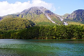 Mount Yake behind Lake Taishō | |
| Highest point | |
| Elevation | 2,455 m (8,054 ft) |
| Coordinates | 36°13′37″N 137°35′13″E / 36.22694°N 137.58694°ECoordinates: 36°13′37″N 137°35′13″E / 36.22694°N 137.58694°E |
| Naming | |
| English translation | Burnt mountain |
| Language of name | Japanese |
| Geography | |
 Mount Yake | |
| Parent range | Hida Mountains |
| Geology | |
| Age of rock | 20,000 years |
| Mountain type | Active stratovolcano |
| Last eruption | February 1995 |
| Climbing | |
| Easiest route | Hiking |

Mount Yake (焼岳, Yake-dake) literally, "Burning mountain" is an active volcano in the Hida Mountains, lying between Matsumoto, Nagano Prefecture, and Takayama, Gifu Prefecture, Japan. It is one of the 100 Famous Japanese Mountains, reaching 2,455 m (8,054 ft) at the highest peak.
Geography[]
Mount Yake is the most active of all the volcanoes in the Hida Mountains. Its two main peaks are the northern and southern peaks, but visitors can only ascend to the northern peak, as the southern peak is currently a restricted area. A crater lake lies between the two peaks.
High viscosity lava flowing from the upper regions of Mount Yake has led to the build up of a lava dome.
The heat from the volcano produces many onsen in the surrounding area.
Eruptions[]
In 1911, 22 minor eruptions were recorded. In 1915, during the Taishō period, however, there was a major eruption. The flow of the lava blocked the , which caused the river to form a lake that was named .[1] The Azusa River is again flowing today, but the lake still remains.
In 1962, there was an eruption that killed two people staying at a small hut near the mouth of the volcano.[1]
In 1995, a tunnel was being constructed on the Nagano Prefecture side of the mountain, through , which was thought to be part of Mount Yake. At 2:25pm on February 11, the workers encountered volcanic gases, which were quickly followed by a phreatic eruption on Mount Yake, leading to the death of four people. Later explorations have shown that Mount Akandana is an independent volcano.
There is still an active fumarole near the mountain's peak.

seen from Mount Hotaka

crater lake between the northern and southern peaks

northern peak and volcanic gases


See also[]
| Wikimedia Commons has media related to Mount Yake (Hida Mountains). |
- 100 Famous Japanese Mountains
- List of volcanoes in Japan
- List of mountains in Japan
References[]
- ^ Jump up to: a b Mount Yake Volcano Disaster Prevention Archived 2011-10-02 at the Wayback Machine. (in Japanese) Ministry of Land, Infrastructure and Transport. Accessed June 30, 2008.
External links[]
- Yakedake - Japan Meteorological Agency (in Japanese)
- "Yakedake: National catalogue of the active volcanoes in Japan" (PDF). - Japan Meteorological Agency
- Yakedake - Geological Survey of Japan
- "Yakedake". Global Volcanism Program. Smithsonian Institution. Retrieved 2021-06-24.
| show Authority control |
|---|
- Volcanoes of Honshū
- Hida Mountains
- Active volcanoes
- Mountains of Gifu Prefecture
- Mountains of Nagano Prefecture
- Chūbu-Sangaku National Park
- Volcanoes of Gifu Prefecture
- Volcanoes of Nagano Prefecture