Mount Jōnen
| Mount Jōnen | |
|---|---|
| 常念岳 | |
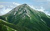
 Mount Jōnen , Mount Yokotooshi and Azusa River in spring from Azumi Basin | |
| Highest point | |
| Elevation | 2,857 m (9,373 ft)[1] |
| Listing | 100 Famous Japanese Mountains List of mountains in Japan |
| Coordinates | 36°19���32″N 137°43′39″E / 36.32556°N 137.72750°ECoordinates: 36°19′32″N 137°43′39″E / 36.32556°N 137.72750°E[2] |
| Naming | |
| Language of name | Japanese |
| Geography | |
 Mount Jōnen Location of Mount Jōnen in Japan. | |
| Location | Azumino, Nagano and Matsumoto, Nagano, Japan |
| Parent range | Jōnen Mountains in Hida Mountains |
| Topo map | Geospatial Information Authority 25000:1 穂高岳 50,000:1 上高地 |
| Climbing | |
| First ascent | Walter Weston in 1894 (Mountaineering) |

Mount Jōnen (常念岳, Jōnen-dake) is one of the 100 Famous Japanese Mountains,[3] reaching the height of 2,857 m (9,373 ft).[1] It is situated in Japan's Hida Mountains in Nagano Prefecture and in Chūbu-Sangaku National Park.[4] The shape of the mountain looks like the triangle. It can be seen from Azumi Basin.
Outline[]
This mountain is formed with Granite.[5] Before 1959 nine kinds of butterfly on high mountains can be seen around the mountain.[6][7] Colias erate and others can be seen now. The shape of the remaining snow of this mountain had decided the time when it farmed. The shape was called Jōnen-Bō (常念坊, Jōnen-Bō).
History[]
- Summer 1894: Englishman Walter Weston became the first man to climb on the top.[5][8]
- Summer 1906: Usui Kojima became the first Japanese man to climb on the top.[3]
- July 27, 1919: Mountain hut of Jōnen Hut (常念小屋, Jōnen-goya) was opened.[9]
- 1922: Kyūya Fukada stayed at the Jōnen Hut, and climbed this mountain.[3]
- June 1931: The double accident of the climbing mountain party and the rescue team occurred.[9]
- December 4, 1934: This area was specified to the Chūbu-Sangaku National Park.[4]
- 1993: Postage stamp of Jōnen Kasa with Matsumoto Castle was put on the market by the Ministry of Posts and Telecommunications (Japan).[10]
- May 28, 2007: NHK broadcasts the television program concerning Mount Jōnen in the series programs of excellent mountain in Japan.[11]
- September 10, 2010: NHK broadcasts the television program concerning Mount Jōnen and the high mountain butterfly.[7]
Mountaineering[]

Main ascent routes[]
There are three climbing routes to the top of the mountain.[12][13]
- Ichino River route
- Hie-Daira - Ichino River (一ノ沢, Ichi-no-sawa) - Munatuki-hachō - Jōnen Hut(Jōnen-Nokkoshi) - Mount Jōnen
- Mount Mae-Jōnen (前常念岳, Mae-Jōnen-dake) route
- Mitsumata(三股) - Hon river - Mount Mae-Jōnen - Mount Jōnen
- Traverses Route of Jōnen Mountains (from north and south)
- There are several stating points to climb.(Kamikōchi, Tokusawa, Yokoo, Mitsumata, from Mount Otensuo, and others)

Mountain hut[]
Thera are several Mountain hut around Mount Jōnen.[13] There is the Campsite on each hut.
- Jōnen Hut (常念小屋) - On the pass of Jōnen Pass (常念乗越, Jōnen-Nokkoshi) between Mount Jōnen and Mount Yokotooshi. It is one of the oldest hut in Japan.
- Mount Chō Hut (蝶ヶ岳ヒュッテ) - Near the top of Mount Chō.
- Yokoo Mountain Cottage (横尾山荘) - In Yokoo most in the north of Kamikochi.
- Daiten Cottage (大天荘) - Near the top of Mount Otensyo.
Geography[]
Nearby Mountains[]
It is on the sub ridge line of Jōnen Mountains in the southeast part of the Hida Mountains. There is a small peak of Mount Mae-Jōnen in the southeast by east.[13]

from Mount Jōnen

from Mount Hotaka
| Image | Mountain | Elevation | Distance from the Top |
Note |
|---|---|---|---|---|

|
Mt. Yari 槍ヶ岳 |
3,180 m (10,433 ft) | 7.4 km (4.6 mi) | 100 Famous |

|
大天井岳 |
2,921.91 m (9,586 ft) | 5.0 km (3.1 mi) | tallest mountain in Jōnen Mountains |

|
横通岳 |
2,766.99 m (9,078 ft) | 1.9 km (1 mi) | |
|
Mt. Jōnen 常念岳 |
2,857 m (9,373 ft) | 0 km (0.0 mi) | 100 Famous |

|
Mt. Mae-Jōnen 前常念岳 |
2,661.78 m (8,733 ft)[14] | 2.0 km (1.2 mi) | |

|
蝶ヶ岳 |
2,677 m (8,783 ft) | 4.2 km (2.6 mi) | 100 Famous |

|
Mt. Hotaka 穂高岳 |
3,190 m (10,466 ft) | 8.2 km (5.1 mi) | tallest mountain in Hida Mountains 100 Famous |
Source river[]
Each source river joins the main stream of Shinano River, then flows to the Sea of Japan.[13]
- Ichinomata Valley (Tributary of Azusa River)
- Jōnen River, Ichino River and Nino river (tributary of Sai (Nagano) River)
Gallery[]

Mount Jōnen from Mount Yari
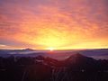
Mount Jōnen and sunrise from Mount Yari

Mount Jōnen where it snowed from Mount Chō
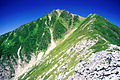
Mount Jōnen in summer from Mount Mae-Jōnen

Mount Yari that turned red in autumn from Mount Jōnen


See also[]
References[]
- ^ Jump up to: a b "Map inspection service of 25000:1 穂高岳". Geospatial Information Authority of Japan. Retrieved December 2, 2010.
- ^ "Mountains altitude list in Japan(Nagano)". Geospatial Information Authority of Japan. Retrieved December 2, 2010.
- ^ Jump up to: a b c 100 Famous Japanese Mountains. The Asahi Shimbun Companyin. 1982. ISBN 4-02-260871-4.
- ^ Jump up to: a b "Chūbu-Sangaku National Park". Ministry of the Environment (Japan). Archived from the original on February 27, 2012. Retrieved December 2, 2010.
- ^ Jump up to: a b 日本山名辞典) [Dictionary of name of Japanese mountain]. Sanseido. 1992. ISBN 4-385-15403-1.
- ^ 1000 Japanese Mountains. YAMA-KEI Publishers. 1992. ISBN 4-635-09025-6.
- ^ Jump up to: a b "The back number of the program (Kita-Alps Mount Jōnen)". NHK. Archived from the original on September 26, 2011. Retrieved December 2, 2010.
- ^ Walter Weston (2005) [1896]. 日本アルプスの登山と探検 [Mountaineering and exploration in Japanese alps] (in Japanese). Translated by Iwanami Shoten (new ed.). ISBN 4-00-334741-2.
- ^ Jump up to: a b The story of mountain huts in Northern Japanese Alps. Tokyo Shimbun. 1997. ISBN 4-8083-0374-4.
- ^ 100 Famous Japanese Mountains with postmark of stamp with the scenery. Hukurōsha. 2007. ISBN 978-4-89806-276-0.
- ^ "Mount Jōnen on Eco channel of NHK". NHK. Retrieved December 2, 2010.
- ^ Alpen guide Kamikōchi,Mount Yari and Mount Hotaka (アルペンガイド). YAMA-KEI Publishers. 2000. ISBN 4-635-01319-7.
- ^ Jump up to: a b c d 山と高原地図 [Mountain and plateau map, Mount Yari, Mount Hotaka and Kamikōchi]. Shobunsha Publications. 2010. ISBN 978-4-398-75717-3.
- ^ "Information inspection service of the Triangulation station". Geospatial Information Authority of Japan,(高山-上高地). Archived from the original on June 9, 2009. Retrieved December 2, 2010.
External links[]
 Media related to Mount Jōnen at Wikimedia Commons
| hide | |||||||||
|---|---|---|---|---|---|---|---|---|---|
| Hokkaidō | |||||||||
| Tōhoku region Jōshinetsu region | |||||||||
| Kantō region | |||||||||
| Chūbu region |
| ||||||||
| Western Japan | |||||||||
| |||||||||
- Hida Mountains
- Chūbu-Sangaku National Park
- Mountains of Nagano Prefecture
- Japan Alps