Matsumoto, Nagano
This article uses bare URLs, which may be threatened by link rot. (July 2021) |
Matsumoto
松本市 | |
|---|---|
 Top:Matsumoto Castle, Middle:A heritage building of Kaichi School, A view of Kamikōchi, Mount Yake and Azusa creek, Bottom:Nawate suvenir shopping street, A street view of Asama Spa (all item from left to right) | |
 Flag  Seal | |
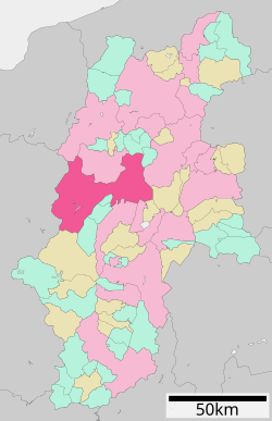
 Location of Matsumoto in Nagano Prefecture | |
 | |
 Matsumoto | |
| Coordinates: 36°14′16.8″N 137°58′19.1″E / 36.238000°N 137.971972°ECoordinates: 36°14′16.8″N 137°58′19.1″E / 36.238000°N 137.971972°E | |
| Country | Japan |
| Region | Chūbu (Kōshin'etsu) |
| Prefecture | Nagano Prefecture |
| First official recorded | 4th century |
| City settled | May 1, 1907 |
| Government | |
| • Mayor | Akira Sugenoya |
| Area | |
| • Total | 978.47 km2 (377.79 sq mi) |
| Population (March 1, 2019) | |
| • Total | 239,466 |
| • Density | 240/km2 (630/sq mi) |
| Time zone | UTC+9 (Japan Standard Time) |
| – Tree | Japanese Red Pine |
| – Flower | Japanese azalea |
| Phone number | 0263-34-3000 |
| Address | 3–7 Marunouchi, Matsumoto-shi, Nagano-ken 390-8620 |
| Website | Official website |

Matsumoto (松本市, Matsumoto-shi) is a city located in Nagano Prefecture, Japan.[1] Matsumoto is designated as a core city since 1 April 2021.[2] As of 1 March 2019, the city had a population of 239,466 in 105,207 households [3] and a population density of 240 persons per km2. The total area of the city is 978.47 square kilometres (377.79 sq mi).
Geography[]
Matsumoto is located in the Matsumoto Basin of central Nagano Prefecture surrounded by mountains and is acclaimed for its beautiful views. It is approximately 75 kilometers south of the prefectural capital at Nagano City, and 167 kilometers from central Tokyo. The 3000 meter Hida Mountains are to the west of the city, with 3190 meter Mount Hotakadake on the border of Matsumoto with Takayama, Gifu as the highest point within the city limits.
Surrounding municipalities[]
- Nagano Prefecture
- Gifu Prefecture
- Takayama
Demographics[]
Per Japanese census data,[4] the population of Matsumoto has been increasing over the past 40 years.
| Year | Pop. | ±% |
|---|---|---|
| 1940 | 154,182 | — |
| 1950 | 183,775 | +19.2% |
| 1960 | 190,076 | +3.4% |
| 1970 | 203,571 | +7.1% |
| 1980 | 223,496 | +9.8% |
| 1990 | 233,756 | +4.6% |
| 2000 | 243,465 | +4.2% |
| 2010 | 243,070 | −0.2% |
Climate[]
Matsumoto has a humid continental climate (Köppen climate classification Dfa) bordering on a humid subtropical climate (Koppen Cfa), with hot summers and cold winters. Precipitation is quite high in summer, but the weather is somewhat drier in winter. The average annual temperature in Matsumoto is 11.9 °C. The average annual rainfall is 1982 mm with September as the wettest month. The temperatures are highest on average in August, at around 25.2 °C, and lowest in January, at around −0.5 °C.[5]
| hideClimate data for Matsumoto, Nagano (1981~2010) | |||||||||||||
|---|---|---|---|---|---|---|---|---|---|---|---|---|---|
| Month | Jan | Feb | Mar | Apr | May | Jun | Jul | Aug | Sep | Oct | Nov | Dec | Year |
| Record high °C (°F) | 18.8 (65.8) |
21.1 (70.0) |
25.9 (78.6) |
30.9 (87.6) |
32.3 (90.1) |
35.9 (96.6) |
37.9 (100.2) |
38.5 (101.3) |
35.3 (95.5) |
31.8 (89.2) |
25.6 (78.1) |
21.5 (70.7) |
38.5 (101.3) |
| Average high °C (°F) | 5.0 (41.0) |
6.0 (42.8) |
10.5 (50.9) |
17.8 (64.0) |
22.9 (73.2) |
26.0 (78.8) |
29.4 (84.9) |
31.1 (88.0) |
25.7 (78.3) |
19.3 (66.7) |
13.6 (56.5) |
8.0 (46.4) |
17.9 (64.2) |
| Daily mean °C (°F) | −0.4 (31.3) |
0.2 (32.4) |
3.9 (39.0) |
10.6 (51.1) |
16.0 (60.8) |
19.9 (67.8) |
23.6 (74.5) |
24.7 (76.5) |
20.0 (68.0) |
13.2 (55.8) |
7.4 (45.3) |
2.3 (36.1) |
11.8 (53.2) |
| Average low °C (°F) | −5.2 (22.6) |
−4.8 (23.4) |
−1.5 (29.3) |
4.1 (39.4) |
9.9 (49.8) |
14.9 (58.8) |
19.2 (66.6) |
20.2 (68.4) |
15.9 (60.6) |
8.4 (47.1) |
2.1 (35.8) |
−2.7 (27.1) |
6.7 (44.1) |
| Record low °C (°F) | −24.8 (−12.6) |
−20.4 (−4.7) |
−17.9 (−0.2) |
−10.1 (13.8) |
−2.7 (27.1) |
2.3 (36.1) |
10.2 (50.4) |
8.0 (46.4) |
3.0 (37.4) |
−3.6 (25.5) |
−8.4 (16.9) |
−19.2 (−2.6) |
−24.8 (−12.6) |
| Average precipitation mm (inches) | 35.9 (1.41) |
43.5 (1.71) |
79.6 (3.13) |
75.3 (2.96) |
100.0 (3.94) |
125.7 (4.95) |
138.4 (5.45) |
92.1 (3.63) |
155.6 (6.13) |
101.9 (4.01) |
54.9 (2.16) |
28.1 (1.11) |
1,031 (40.59) |
| Average snowfall cm (inches) | 28 (11) |
24 (9.4) |
17 (6.7) |
1 (0.4) |
0 (0) |
0 (0) |
0 (0) |
0 (0) |
0 (0) |
0 (0) |
0 (0) |
9 (3.5) |
79 (31) |
| Average precipitation days (≥ 0.5 mm) | 6.0 | 6.6 | 9.6 | 9.1 | 9.7 | 11.1 | 13.1 | 9.7 | 11.2 | 9.0 | 6.3 | 5.4 | 106.8 |
| Average snowy days | 11.2 | 9.8 | 4.9 | 0.4 | 0.0 | 0.0 | 0.0 | 0.0 | 0.0 | 0.0 | 0.0 | 3.7 | 30 |
| Mean monthly sunshine hours | 170.7 | 163.5 | 185.0 | 202.1 | 209.0 | 163.6 | 171.3 | 205.4 | 141.8 | 159.9 | 159.2 | 166.0 | 2,097.5 |
| Source 1: Japan Meteorological Agency[6] | |||||||||||||
| Source 2: Japan Meteorological Agency (records)[7] | |||||||||||||
History[]
Matsumoto is located in former Shinano Province and was the provincial capital from the Heian period onwards. The area developed as the castle town of Matsumoto Domain under the Tokugawa shogunate of the Edo period. Modern Matsumoto Town was established with the creation of the municipalities system on April 1, 1889. It was raised to city status on May 1, 1907.
On February 1, 1925 Matsumoto absorbed the village of Matsumoto (from Higashichikuma District).
The city expanded further by annexing the Kanda hamlet of the village of Nakayama from Higashichikuma District on April 1, 1943, the villages of Nakayama, Shimadachi and Shimauchi (all from Higashichikuma District) on April 1, 1954, the villages of Wada, Niimura, Kanbayashi, Sasaga, Yoshikawa, Kotobuki, Okada, Iriyamabe, Satoyamabe and Imai (all from Higashichikuma District) on August 1, 1954 and Kitauchida ward (excluding the Gakenoyu hamlet from the Minamiuchida ward of the village of Kataoka, from Higashichikuma District) from the city of Shiojiri on April 1, 1960. This was followed by the Gakenoyu hamlet of Minamiuchida ward of the village of Kataoka (from Higashichikuma District) from the city of Shiojiri on April 1, 1961, the village of Hongo (from Higashichikuma District) on May 1, 1974 and parts of Seba hamlet (the hamlet of Kukohigashi) from the city of Shiojiri on April 1, 1982.
Between the days of June 27 and June 28, 1994, the Matsumoto Incident sarin gas attack occurred.
Matsumoto was proclaimed a special city with increased local autonomy on November 1, 2000. Matsumoto annexed the villages of Azumi, Azusagawa and Nagawa (all from Minamiazumi District), and the village of Shiga (from Higashichikuma District) on April 1, 2005. This was followed by the town of Hata (from Higashichikuma District) on March 31, 2010. Matsumoto was proclaimed a core city with increased local autonomy on April 1, 2021.
Government[]
Matsumoto has a mayor-council form of government with a directly elected mayor and a unicameral city legislature of 31 members. The city contributes six members to the Nagano Prefectural Assembly. In terms of national politics, Matsumoto is grouped with Ōmachi, Azumino, Higashichikuma District, Nagano, Kitaazumi District, Nagano, Kamiminochi District, Nagano and part of the city of Nagano to form Nagano 2nd District in the lower house of the National Diet.
List of Matsumoto Mayors (since 1937)[]
- Yorinaga Ori (小里頼永) July 1937 to August 1937
- Okimasa Momose (百瀬興政) August 1937 to April 1939
- Wataru Momose (百瀬 渡) April 1940 to April 1944
- Morito Hirabayashi (平林盛人) May 1944 to March 1945
- Yasushi Hirayama (平山 泰) July 1945 to March 1946
- Ikuichi Akahane (赤羽幾一) June 1946 to December 1946
- Naohisa Tsutsui (筒井直久) April 1947 to April 1951
- Bunshichiro Matsuoka(松岡文七郎) April 1951 to January 1957
- Tokuya Furuhata (降旗徳弥) March 1957 to March 1969
- Matsumi Fukasawa (深沢松美) March 1969 to March 1976
- Shoji Wago (和合正治) March 1976 to March 1992
- Tadashi Aruga (有賀 正) March 1992 to March 2004
- Akira Sugenoya (菅谷 昭) March 2004 to March 2020
- Yoshinao Woun (臥雲義尚) March 2020 to present
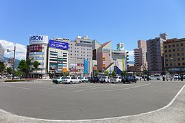
Economy[]
Matsumoto is a regional commercial center and noted for traditional woodworking and silk spinning, electronics and its dairy industry. Seasonal tourism to the surrounding mountains and onsen hot spring resorts is also an important source of local income.[8]
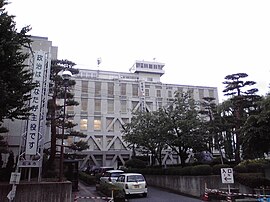
Education[]
Universities and colleges[]
- Shinshu University
- Matsumoto University
- Matsusho Gakuen Junior College
- Matsumoto Junior College
Primary and secondary education[]
Matsumoto has 29 public elementary schools operated by the city government, one operated by the national government and one private elementary school. The city also manages 19 public middle schools, with one more middle school shared between Matsumoto and neighbouring Asahi. There is one public middle school operated by the national government and one private middle school. The city has seven public high schools operated by the Nagano Prefectural Board of Education and six private high schools. The city also has a North Korean school, Nagano Korean Elementary and Junior High School (長野朝鮮初中級学校).
Transportation[]
Airport[]
Railway[]
 East Japan Railway Company – Shinonoi Line
- Murai – Hirata – Minami-Matsumoto – Matsumoto
- East Japan Railway Company – Ōito Line
- Alpico Kōtsū – Kamikōchi Line
- Matsumoto – Nishi-Matsumoto – Nagisa – Shinano-Arai – Ōniwa – Shimonii – Kitanii-Matsumotodaigakumae – Niimura – Samizo – Moriguchi – Shimojima – Hata – Endō – Shin-Shimashima
Highway[]
 Nagano Expressway
 National Route 19
 National Route 143
 National Route 147
 National Route 158
 National Route 254
 National Route 403
Sister city relations[]
Domestic[]
- Fujisawa, Kanagawa, from July 29, 1961
- Himeji, Hyōgo, from November 17, 1966
- Takayama, Gifu, from November 1, 1971
International[]
 Salt Lake City, Utah, United States, from 1958
 Kathmandu, Nepal, from November 17, 1989
 Langfang, Hebei, China, friendship city from March 21, 1995
 Grindelwald, Canton of Bern, Switzerland, from April 20, 1972
Local attractions[]
Matsumoto is attractive to travellers not only because of the traditional culture but also its moderate climate and local products. Matsumoto soba is famous for its delicate taste.[9] Local attractions include:
- Matsumoto Castle, built more than 400 years ago. It is a Japanese National Treasure
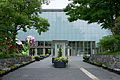
- Kaichi School Museum, Meiji period building housing the first middle school in Japan
- Asama Onsen
- Kōbōyama Kofun, Kofun period burial mound, a National Historic Site
- Hayashi Castle, Sengoku period castle ruins, a National Historic Site
- Saito Kinen Festival Matsumoto, held every August by conductor Seiji Ozawa and featuring the Saito Kinen Orchestra
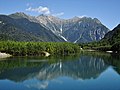
- Kamikōchi mountain area
- The Kiso Valley, a valley located Southwest of Matsumoto along which the historic Nakasendo route of the Edo period went through
Outside the rail station is also a statue of a little girl with a violin, remembering the Suzuki method of teaching music, created by Shinichi Suzuki who lived in the city in his later life.
Sports[]
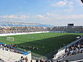
Matsumoto is represented in the J. League of football with its local club, Matsumoto Yamaga FC based at the Alwin Stadium in Kambayashi.
It was one of the host cities of the official Women's Volleyball World Championship for its 1998 and 2010 editions.
Yoshinori Ueda was born here.[10]
Gallery[]

Four Pillars Shrine

Kaichi School
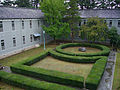
Garden in former Matsumoto High School (present day of Shinshu University)
Matsumoto Alwin football stadium

View of downtown Matsumoto from Mount Koubou

Kappa Bridge in Kamikōchi
Matsumoto City Museum of Art

Matsumoto Ukiyoe Museum

Azusa River in Kamikōchi
Taisho Pond in Kamikōchi


References[]
- ^ Nussbaum, Louis-Frédéric. (2005). "Maatsumoto" in Japan Encyclopedia, p. 618; "Chūbu" at p. 126.
- ^ Jacobs, A. J. "Japan's Evolving Nested Municipal Hierarchy: The Race for Local Power in the 2000s", Urban Studies Research, (2011); Table 3; retrieved 20132-2-11.
- ^ "松本市ホームぺージ". www.city.matsumoto.nagano.jp.
- ^ "Nagano (Japan): Prefecture, Cities, Towns and Villages – Population Statistics, Charts and Map". www.citypopulation.de.
- ^ "Matsumoto climate: Average Temperature, weather by month, Matsumoto weather averages - Climate-Data.org". en.climate-data.org.
- ^ 平年値(年・月ごとの値). Japan Meteorological Agency. Retrieved 2010-03-06.
- ^ 観測史上1~10位の値(年間を通じての値). Japan Meteorological Agency. Retrieved 2011-11-18.
- ^ Campbell, Allen; Nobel, David S (1993). Japan: An Illustrated Encyclopedia. Kodansha. p. 1147. ISBN 406205938X.
- ^ http://welcome.city.matsumoto.nagano.jp/contents03+index.id+15.htm
- ^ "Yoshinori Ueda Japanese Leagues Statistics & History". Baseball-Reference. Sports Reference. Retrieved 2020-08-09.
External links[]
![]() Media related to Matsumoto, Nagano at Wikimedia Commons
Media related to Matsumoto, Nagano at Wikimedia Commons
| Wikivoyage has a travel guide for Matsumoto. |
- Official Website (in Japanese)
- Matsumoto City Tourism Website (in English)
| show |
|---|
| show Authority control |
|---|
- Matsumoto, Nagano
- Cities in Nagano Prefecture