Wakayama (city)
This article needs additional citations for verification. (May 2015) |
Wakayama
和歌山市 | |
|---|---|
| Wakayama City | |
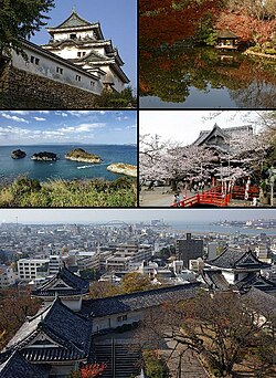 Wakayama Castle, Nishinomaru Garden, Saikazaki, Kimiidera Temple, Downtown Wakayama viewed from the castle keep | |
 Flag  Seal | |
 Location of Wakayama in Wakayama Prefecture | |
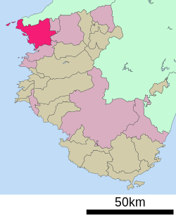 | |
 Wakayama Location of Wakayama in Wakayama Prefecture | |
| Coordinates: 34°14′N 135°10′E / 34.233°N 135.167°ECoordinates: 34°14′N 135°10′E / 34.233°N 135.167°E | |
| Country | Japan |
| Region | Honshu (Kansai) |
| Prefecture | Wakayama Prefecture |
| Government | |
| • Mayor | Masahiro Obana |
| Area | |
| • Land | 210.25 km2 (81.18 sq mi) |
| Population (1 May 2017) | |
| • Total | 360,664 |
| • Density | 1,730/km2 (4,500/sq mi) |
| Time zone | UTC+9 (Japan Standard Time) |
| - Tree | Cinnamomum camphora |
| - Flower | Azalea |
| Website | www |

Wakayama (和歌山市, Wakayama-shi, Japanese: [ɰakaꜜjama]) is the capital city of Wakayama Prefecture in the Kansai region of Japan. As of May 1, 2017, the city has an estimated population of 360,664.
Background[]
The city population rose from 382,155 in 2003 to 386,501 in 2004, a growth of 1.87%. The population density as of October 1, 2010, was 1,755.47 persons per km2. The total area is 209.20 km2.
This population increase has occurred despite Wakayama's beleaguered economy, which has suffered since Sumitomo Steel moved much of its steel producing operations to China. The Wakayama steel mills have since been reduced and restructured, with part of the industry completely shutting in 2004.
Wakayama is cleft in two by the Kinokawa River. The city is bordered at the north by mountains and Osaka Prefecture.
In the city center is Wakayama Castle, built on Mt. Torafusu (the name means "a tiger leaning on his side") in a city central park. During the Edo period, the Kishū Tokugawa daimyō ruled from Wakayama Castle. Tokugawa Yoshimune, the fifth Kishū Tokugawa daimyō, became the eighth . This castle is a concrete replica of the original, which was destroyed in World War II.
Wakayama is home to one of Japan's three Melody Roads, which is made from grooves cut into the pavement, which when driven over causes a tactile vibration and audible rumbling transmitted through the wheels into the car body.[1][2]
Wakayama Prefecture is famous across Japan for its umeboshi (salty pickled plums) and mikan (mandarins).
Climate[]
Wakayama has a humid subtropical climate (Köppen climate classification Cfa) with hot summers and cool winters. Precipitation is significant throughout the year, and is greater in summer than in winter.
| hideClimate data for Wakayama (1991−2020 normals, extremes 1879−present) | |||||||||||||
|---|---|---|---|---|---|---|---|---|---|---|---|---|---|
| Month | Jan | Feb | Mar | Apr | May | Jun | Jul | Aug | Sep | Oct | Nov | Dec | Year |
| Record high °C (°F) | 21.2 (70.2) |
22.0 (71.6) |
24.5 (76.1) |
30.0 (86.0) |
32.4 (90.3) |
35.3 (95.5) |
37.8 (100.0) |
38.5 (101.3) |
35.8 (96.4) |
32.3 (90.1) |
27.7 (81.9) |
25.2 (77.4) |
38.5 (101.3) |
| Average high °C (°F) | 9.8 (49.6) |
10.7 (51.3) |
14.3 (57.7) |
19.7 (67.5) |
24.3 (75.7) |
27.1 (80.8) |
31.1 (88.0) |
32.6 (90.7) |
29.0 (84.2) |
23.4 (74.1) |
17.9 (64.2) |
12.5 (54.5) |
21.0 (69.8) |
| Daily mean °C (°F) | 6.2 (43.2) |
6.7 (44.1) |
9.9 (49.8) |
15.1 (59.2) |
19.7 (67.5) |
23.2 (73.8) |
27.2 (81.0) |
28.4 (83.1) |
24.9 (76.8) |
19.3 (66.7) |
13.8 (56.8) |
8.6 (47.5) |
16.9 (62.4) |
| Average low °C (°F) | 2.9 (37.2) |
3.1 (37.6) |
5.8 (42.4) |
10.7 (51.3) |
15.6 (60.1) |
20.1 (68.2) |
24.3 (75.7) |
25.1 (77.2) |
21.5 (70.7) |
15.6 (60.1) |
9.9 (49.8) |
5.1 (41.2) |
13.3 (55.9) |
| Record low °C (°F) | −6.0 (21.2) |
−5.4 (22.3) |
−4.0 (24.8) |
−1.4 (29.5) |
3.7 (38.7) |
9.0 (48.2) |
14.4 (57.9) |
13.5 (56.3) |
11.2 (52.2) |
4.3 (39.7) |
−0.6 (30.9) |
−3.0 (26.6) |
−6.0 (21.2) |
| Average precipitation mm (inches) | 48.7 (1.92) |
62.0 (2.44) |
96.9 (3.81) |
98.4 (3.87) |
146.6 (5.77) |
183.5 (7.22) |
175.8 (6.92) |
101.8 (4.01) |
181.3 (7.14) |
160.8 (6.33) |
95.9 (3.78) |
62.7 (2.47) |
1,414.4 (55.69) |
| Average snowfall cm (inches) | 0 (0) |
1 (0.4) |
0 (0) |
0 (0) |
0 (0) |
0 (0) |
0 (0) |
0 (0) |
0 (0) |
0 (0) |
0 (0) |
0 (0) |
1 (0.4) |
| Average precipitation days (≥ 0.5 mm) | 7.2 | 7.9 | 10.3 | 10.0 | 10.4 | 12.5 | 10.6 | 7.2 | 10.2 | 9.6 | 7.3 | 7.7 | 111.1 |
| Average relative humidity (%) | 61 | 61 | 60 | 61 | 64 | 72 | 73 | 70 | 69 | 67 | 66 | 63 | 66 |
| Mean monthly sunshine hours | 135.8 | 143.1 | 179.6 | 196.9 | 207.6 | 157.6 | 206.1 | 239.9 | 173.2 | 169.9 | 147.7 | 135.4 | 2,100.1 |
| Source: Japan Meteorological Agency[3] | |||||||||||||
Transportation[]
- West Japan Railway Company
- Wakayama Electric Railway
Sightseeing spots[]
- Wakayama Castle
- Kimiidera
- Hinokuma Shrine
- Kamayama Shrine
- Kishū Tōshō-gū
- Wakayama Marina City[4]
- The Museum of Modern Art, Wakayama

Art Cube of Wakanoura

Kimiidera

The Museum of Modern Art, Wakayama


Education[]
This section needs expansion. You can help by . (October 2015) |
The city has a North Korean school, (和歌山朝鮮初中級学校).[5]
Sister cities[]
Wakayama has sister-city relationships with four overseas municipalities:[6]
 Bakersfield, California, United States
 Jeju, South Korea
 Richmond, British Columbia, Canada
 Jinan, Shandong, China
Wakayama City formed a sister-city relationship with the city of Jinan mainly due to the efforts of Hiroshi Yamazaki (山崎 宏), who was an escaped medic in the Imperial Japanese Army and stayed in China after the war. He married and runs his own clinic in China. In 1976, he visited Wakayama after nearly 40 years.[citation needed]
References[]
- ^ Johnson, Bobbie (13 November 2007). "Japan's melody roads play music as you drive". The Guardian. Farringdon Road, London, England: GMG. p. 19 (International section). Retrieved 20 October 2008.
- ^ "Your car as a musical instrument - Melody Roads". Noise Addicts. 29 September 2008. Retrieved 20 October 2008.
- ^ 気象庁 / 平年値(年・月ごとの値). Japan Meteorological Agency. Retrieved May 19, 2021.
- ^ "Archived copy". Archived from the original on 23 September 2015. Retrieved 26 August 2015.CS1 maint: archived copy as title (link)
- ^ ウリハッキョ一覧. Chongryon. Retrieved October 14, 2015. (Archive).
- ^ "Archived copy". Archived from the original on 2011-02-20. Retrieved 2011-02-19.CS1 maint: archived copy as title (link)
External links[]
| Wikimedia Commons has media related to Wakayama, Wakayama. |
| Wikivoyage has a travel guide for Wakayama. |
- Wakayama City official website (in Japanese)
- Wakayama City official website (in English)
- Wakayama City official Youtube channel(in Japanese)
- Wakayama City Tourist Association (in English)
- Waiker's Guide Map to Wakayama (in English)
 Geographic data related to Wakayama at OpenStreetMap
| show Authority control |
|---|
- Wakayama (city)
- Cities in Wakayama Prefecture
- Port settlements in Japan
- Populated coastal places in Japan