Itabashi
Itabashi
板橋区 | |
|---|---|
Special ward | |
| Itabashi City | |
 The east exit of Itabashi Station | |
 Flag  Emblem | |
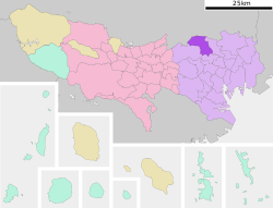 Location of Itabashi in Tokyo Metropolis | |
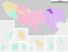
 Itabashi Location in Japan | |
| Coordinates: 35°46′N 139°41′E / 35.767°N 139.683°ECoordinates: 35°46′N 139°41′E / 35.767°N 139.683°E | |
| Country | Japan |
| Region | Kantō |
| Prefecture | Tokyo Metropolis |
| First official recorded | 990 AD |
| As merged with Tokyo City | October 1, 1932 |
| As speciali ward of Tokyo | July 1, 1943 |
| Government | |
| • Mayor | Takeshi Sakamoto (since April 2007) |
| Area | |
| • Total | 32.22 km2 (12.44 sq mi) |
| Population (May 1, 2015) | |
| • Total | 547,270 |
| • Density | 16,990/km2 (44,000/sq mi) |
| Time zone | UTC+09:00 (JST) |
| City hall address | Itabashi 2-66-1, Itabashi-ku, Tokyo 173-8501 |
| Website | www |
| Symbols | |
| Bird | Motacilla alba |
| Flower | Anemone flaccida |
| Tree | Zelkova serrata |

Itabashi (板橋区, Itabashi-ku) is a special ward located in Tokyo Metropolis, Japan. In English, it calls itself Itabashi City. Itabashi has sister-city relations with Burlington, Ontario, in Canada; Shijingshan District of Beijing in the People's Republic of China; and Bologna in Italy.
As of May 1, 2015, the ward has an estimated population of 547,270, and a population density of 16,990 persons per km2. The total area is 32.22 km2.
Geography[]
Itabashi lies on the Kantō plain. The Arakawa River, a major river, forms part of the boundary with Saitama Prefecture. Surrounding the ward are, in Saitama, the cities of Wakō and Toda; and in Tokyo, the wards of Nerima, Toshima, and Kita.
Districts and neighborhoods[]
|
|
Notes:
a – (2, 3, 4, 5, 6, 7, 8-chōme)
b – (formerly part of Shimura Nishidai-chō area)
c – (1 & 9-chōme)
History[]
The name of the ward means "plank bridge" and derives from the wooden span over the Shakujii River that dates from the Heian period. Such a bridge was remarkable at the time, and the name has lasted since. In the Edo period, the Nakasendō crossed the nearby Shimo Itabashi, and the name came to apply to that area as well. Itabashi was one of the Four Edo Post Towns, and travellers first lodged there after leaving the shogunal capital. Kaga Domain had a mansion there. The shogunate maintained the Itabashi execution grounds at Itabashi.
On October 1, 1932, nine towns and villages of were merged and became part of Tokyo City as Itabashi Ward. It became a special ward May 3, 1947. On August 1 of that year, the localities of Nerima, Kami-Nerima, Naka-Arai, Shakujii and Ōizumi were split off from Itabashi to create Nerima Ward.
Education[]
Universities[]
Itabashi is home to four universities. Tokyo Kasei University has a campus in the Kaga neighborhood. Also in Kaga is the main campus of Teikyo University. Daito Bunka University has one campus in Takashima-daira, and another in Higashimatsuyama, Saitama. The fourth is the medical college of Nihon University.
Public schools[]
Public elementary and middle schools are operated by the Itabashi Board of Education.
Public high schools are operated by the Tokyo Metropolitan Board of Education.
- Itabashi High School
- Itabashi Yutoku
- Kitatoshima Technical High School
- Kitazono High School
- Ohyama High School
- Takashima High School
Private schools[]
- Tokyo Third Korean Elementary School (東京朝鮮第三初級学校) – North Korean school[1]
Points of interest[]
- Akatsuka Botanical Garden
- Itabashi Botanical Garden
- Jorenji temple and the Daibutsu of Tokyo
- Jōhoku-Chūō Park
Transportation[]
Rail[]
- East Japan Railway Company (JR East) Saikyō Line: Itabashi Station, Ukima-Funado Station
- Toei Mita Line: Shin-Itabashi, Itabashi Kuyakusho-mae, Itabashi-Honchō, Moto-Hasunuma, Shimura Sakaue, Shimura-Sanchōme, Hasune, Nishidai, Takashimadaira, Shin-Takashimadaira, Nishi-Takashimadaira Stations
- Tokyo Metro Yūrakuchō Line: Chikatetsu Narimasu Station
- Tōbu Tōjō Line: Ōyama, Naka-Itabashi, Tokiwadai, Kami-Itabashi, Tobu-Nerima, Shimo-Akatsuka, Narimasu Stations
Some of these stations straddle the boundaries with other wards, or are within walking distance of Itabashi. The addresses of some stations are in neighboring wards. Shimo-Itabashi Station is in Toshima; Kotake Mukaihara Station and Akatsuka Subway Station are in Nerima; Ukima-Funado Station is actually in Kita.
Highways[]
- Shuto Expressway
- No.5 Ikebukuro Route (Takebashi JCT – Bijogi JCT)
- C2 Central Loop (Itabashi JCT – Kasai JCT)
Sister cities[]
 Shijingshan District, Beijing, China
 Bologna, Italy
 Burlington, Ontario, Canada
Notable people from Itabashi[]
- Tsubasa Akimoto, actress
- Noriyuki Asakura, composer and vocalist
- Yasuhiko Fukuda, Japanese composer and keyboardist
- Tomoko Ikuta, actress
- Shō Ishikawa, Japanese baseball player
- Seizō Katō, actor, voice actor and narrator
- Masakatsu Koike, Japanese politician
- Jin Matsubara, Japanese politician
- Junko Mihara, Japanese politician, singer, actress, and racing driver
- Kayo Noro, Japanese idol, singer and entertainer
- Takurō Ōno, Japanese actor and talent
- Koichi Oshima, baseball player
- Yosuke Santa Maria, Japanese professional wrestler
- Jin Shirosaki, entertainer and radio personality
- Kento Yamazaki, Japanese actor and model
See also[]
Other locations with the same kanji (板橋, read Itabashi during Japanese rule):
- Banqiao District, New Taipei, Taiwan
- Pangyo, South Korea
- Banqiao (disambiguation)
References[]
- ^ "Archived copy" ウリハッキョ一覧. Chongryon. Archived from the original on October 14, 2015. Retrieved October 14, 2015.
東京朝鮮第三初級学校 173-0033 東京都板橋区大山西町67-25-6
CS1 maint: archived copy as title (link) CS1 maint: bot: original URL status unknown (link)().
External links[]
| Wikimedia Commons has media related to Itabashi, Tokyo. |
| Wikivoyage has a travel guide for North Tokyo. |
- Itabashi City Official Website (in Japanese)
| show Tokyo Metropolis |
|---|
| show Authority control |
|---|
- Itabashi
- Wards of Tokyo