Nagano Expressway
This article needs additional citations for verification. (April 2013) |
 | |
|---|---|
| 長野自動車道 | |
| Route information | |
| Maintained by East Nippon Expressway Company and Central Nippon Expressway Company | |
| Length | 75.8 km[1] (47.1 mi) |
| Existed | 1986[2]–present |
| Major junctions | |
| From | in Okaya, Nagano |
| To | in Chikuma, Nagano |
| Location | |
| Major cities | Shiojiri, Matsumoto, Azumino |
| Highway system | |
| National highways of Japan Expressways of Japan | |
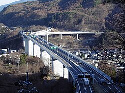
The Nagano Expressway (長野自動車道, Nagano Jidōsha-dō) is a 4-laned national expressway in Nagano Prefecture, Japan. It is owned and operated by East Nippon Expressway Company and Central Nippon Expressway Company.
Naming[]
The expressway is officially referred to as the Chūō Expressway Nagano Route. The Chūō Expressway Nagano Route is the official designation for the Chūō Expressway between and Okaya Junction (concurrent with the Chūō Expressway Nishinomiya Route), the Nagano Expressway between Okaya Junction and Kōshoku Junction, and the Jōshin-etsu Expressway between Kōshoku Junction and (concurrent with the Kan-Etsu Expressway Jōetsu Route).[3]
Overview[]
The expressway was originally built and managed by Japan Highway Public Corporation. On October 1, 2005, the management of the route was assigned to East Nippon Expressway Company (Kōshoku Junction to , excluding the interchange) and Central Nippon Expressway Company (Okaya Junction to Azumino Interchange, including the interchange).[4][5]
The route of the expressway runs through the central part of Nagano Prefecture. From the origin at a junction with the Chūō Expressway in the city of Okaya near Lake Suwa, the expressway follows a northerly course to Matsumoto, the major city in the central Nagano area. From here the expressway follows a winding northeasterly course through mountainous areas before reaching the terminus in the city of Chikuma. Beyond the terminus, the roadway continues as the Jōshin-etsu Expressway towards the city of Nagano, the prefectural capital.
History[]
- March 25, 1986 - Okaya Junction - Okaya Interchange section is opened as part of the Chūō Expressway.
- March 5, 1988 - Okaya Interchange - Matsumoto Interchange section is opened, Okaya Junction - Okaya Interchange section is incorporated as part of the Nagano Expressway.
- August 3, 1988 - Matsumoto Interchange - Toyoshina Interchange section is opened.
- March 25, 1993 - Toyoshina Interchange - Kōshoku Junction section is opened, connects with Jōshin-etsu Expressway.
- October 1, 2006 - Obasute Smart Interchange is opened at Obasute Service Area.
List of interchanges and features[]
- IC - interchange, SIC - smart interchange, JCT - junction, SA - service area, PA - parking area, BS - bus stop, CB - snow chains, TN - tunnel, BR - bridge
| No. | Name | Connections | Dist. from Origin |
Dist. from Terminus |
Bus Stop | Notes | Speed Limit | Location (all in Nagano) | |
|---|---|---|---|---|---|---|---|---|---|
| (21) | 0.0 | 75.8 | 70 km/h | Okaya | |||||
| BR | ↓ | ↑ | Length - 1,488m | ||||||
| TN | ↓ | ↑ | North-bound 1,450 m South-bound 1,386 m | ||||||
| 1 | 3.7 | 72.1 | ○ | ||||||
| TN | ↓ | ↑ | North-bound 1,800 m South-bound 1,707 m | ||||||
| Shiojiri | |||||||||
| PA | 8.4 | 67.4 | ○ | ||||||
| 2 | 10.9 | 64.9 | |||||||
| 100 km/h | |||||||||
| BS | 14.1 | 61.7 | ○ | ||||||
| 3 | Pref. Route 27 (Matsumoto Airport Shiojiri-kita Inter Route) | 17.6 | 58.2 | ||||||
| BR | ↓ | ↑ | Matsumoto | ||||||
| BS | 21.0 | 54.8 | ○ | ||||||
| <3-1> | ↓ | ↑ | Planned | ||||||
| 4 | 25.8 | 50.0 | ○ | ||||||
| SA | Pref. Route 48 (Matsumoto Kanjō Takaya Route) | 29.1 | (46.7) | Kōshoku-bound only | |||||
| BR | ↓ | ↑ | Length - 390m | ||||||
| Azumino | |||||||||
| SA | (29.9) | 45.9 | Okaya-bound only | ||||||
| 5 | Pref. Route 57 (Azumino Inter Horigane Route) Pref. Route 310 (Hakuyachō Tazawa Teishajō Route) |
33.1 | 42.7 | ○ | |||||
| 80 km/h | |||||||||
| BR | ↓ | ↑ | Length - 650m | ||||||
| BS | 36.5 | 39.3 | ○ | ||||||
| TN | ↓ | ↑ | North-bound 2,512 m South-bound 2,536 m | ||||||
| BS | 40.5 | 35.3 | ○ | Emergency vehicle entrance/exit | Matsumoto | ||||
| TN | ↓ | ↑ | North-bound 3,629 m South-bound 3,598 m | ||||||
| Chikuhoku | |||||||||
| BS | 47.3 | 28.5 | ○ | Emergency vehicle entrance/exit | |||||
| BS | 51.5 | 24.3 | ○ | ||||||
| PA | 52.8 | 23.0 | SIC planned | ||||||
| Omi | |||||||||
| 6 | 56.3 | 19.5 | ○ | ||||||
| TN | ↓ | ↑ | North-bound 3,191 m South-bound 3,203 m | ||||||
| Chikuma | |||||||||
| SA | 63.6 | 12.2 | ○ | ||||||
| BR | ↓ | ↑ | Length - 530m | Nagano | |||||
| Chikuma | |||||||||
| 7 | 74.9 | 0.9 | ○ | ||||||
| (12) | 75.8 | 0.0 | |||||||
| Through to | |||||||||
There is one snow chain changing area between Obasute Service Area and Kōshoku Interchange.
References[]
- ^ Ministry of Land, Infrastructure and Transport, Kanto Regional Development Bureau. "Road Timetable" (in Japanese). Archived from the original on 2004-06-04. Retrieved 2008-04-16.CS1 maint: multiple names: authors list (link)
- ^ "Expressway Opening Dates" (in Japanese). Retrieved 2008-04-16.
- ^ Ministry of Land; Infrastructure and Transport. "High Standard Trunk Road Map" (PDF) (in Japanese). Archived from the original (PDF) on 2011-09-20. Retrieved 2008-04-13.
- ^ Mizutani, Fumitoshi; Uranishi, Shuji (2006). Privatization of the Japan Highway Public Corporation: Policy Assessment (PDF). 46th Congress for the European Regional Science Association. Volos, Greece. Retrieved 2008-04-11.
- ^ "NEXCO-Central Business Outline" (PDF). Retrieved 2008-04-13.[permanent dead link]
External links[]
- Expressways in Japan