Higashi-Kantō Expressway
This article needs additional citations for verification. (April 2013) |
 | |
|---|---|
| Route information | |
| Length | 74.5 km[1] (46.3 mi) |
| Existed | 1971[2]–present |
| Major junctions | |
| From | Kōya Junction |
| To | Ibaraki Junction |
| Location | |
| Major cities | Funabashi, Narashino, Chiba, Sakura, Narita, Katori, Itako |
| Highway system | |
| National highways of Japan Expressways of Japan | |

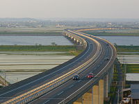
The Higashi-Kantō Expressway (東関東自動車道, Higashi Kantō Jidōsha-dō) (lit. East Kantō Expressway) is a national expressway in Japan. It is owned and operated by East Nippon Expressway Company.
Overview[]
Officially the expressway is referred to as the Higashi-Kantō Expressway Mito Route.[3]
The expressway commences at a junction with the Shuto Expressway Bayshore Route in western Chiba Prefecture and follows an easterly course which parallels Tokyo Bay. Just before where the expressway meets the Keiyō Road, the route branches away from the bay and heads inland in a northeasterly direction. It continues through Chiba Prefecture, though the city of Narita, and crossing the Tone River into Ibaraki Prefecture where the expressway reaches its current terminus in Itako.
The expressway is an important route linking the greater Tokyo area with Narita International Airport. At travellers must switch to the Shin-Kūkō Expressway to travel the remaining distance to the airport proper.
Currently the expressway extends from to , however plans are underway to extend the expressway to a junction with the Kita-Kantō Expressway near Mito, Ibaraki.[4]
The expressway is 6 lanes from the origin to Narita Junction, and the remainder is 4 lanes. The speed limit is 100 km/h, except for the section from the origin to which is 80 km/h.
List of interchanges and features[]
- IC - interchange, JCT - junction, PA - parking area, SA - service area, BR - bridge, TB - toll gate
| No. | Name | Connections | Dist. from Origin |
Dist. from Terminus |
Notes | Location | |
|---|---|---|---|---|---|---|---|
| Through to | |||||||
| 0.0 | 123.0 | Ichikawa | Chiba | ||||
| 1 | |||||||
| 2 | 1.0 | 122.0 | Ichikawa-bound exit, Itako-bound entrance only | ||||
| 2-1 | Pref. Route 15 (Chiba Funabashi-Kaihin Route) |
5.5 | 117.5 | Itako-bound exit, Ichikawa-bound entrance only | Funabashi | ||
| 3 | 7.9 | 115.1 | Itako-bound exit, Ichikawa-bound entrance only | Narashino | |||
| TB | ↓ | ↑ | |||||
| PA | 8.7 | 114.3 | Mihama-ku, Chiba | ||||
| 4 | 11.6 | 111.4 | Ichikawa-bound exit, Itako-bound entrance only | ||||
| 5 | 16.7 | 106.3 | No access: Keiyō southbound → Higashi-Kantō westbound Higashi-Kantō eastbound → Keiyō northbound |
Inage-ku, Chiba | |||
| 6 | 18.8 | 104.2 | |||||
| 7 | Pref. Route 64 (Chiba Usui Inzai Route) | 24.6 | 98.4 | Yotsukaidō | |||
| 8 | 30.0 | 93.0 | Sakura | ||||
| PA | 35.1 | 87.9 | Shisui | ||||
| <8-1> | 37.0 | 86.0 | |||||
| 9 | 39.5 | 83.5 | Tomisato | ||||
| 10 | / | 44.9 | 78.1 | Narita | |||
| <10-1> | 51.5 | 71.5 | |||||
| PA | 51.6 | 71.4 | |||||
| 11 | 56.6 | 66.4 | |||||
| 12 | Pref. Route 55 (Sawara Yamada Route) Pref. Route 253 (Katori Tsunomiya Route) |
65.9 | 57.1 | Katori | |||
| PA | 68.5 | 54.5 | |||||
| BR | ↓ | ↑ | Length - 630 m | ||||
| BR | ↓ | ↑ | Itako | Ibaraki | |||
| 13 | Pref. Route 50 (Mito Kamisu Route) Pref. Route 101 (Itako Sawara Route) |
74.5 | 48.5 | ||||
| <14> | Pref. Route 50 (Mito Kamisu Route) | 85.6 | 37.4 | Planned | Namegata | ||
| <15> | 97.5 | 23.5 | Planned | ||||
| 16 | Pref. Route 18 (Ibaraki Kashima Route) | 105.4 | 17.6 | Hokota | |||
| 17 | Pref. Route 18 (Ibaraki Kashima Route) | 114.2 | 8.8 | Ibaraki | |||
| 15-1 | 123.0 | 0.0 | |||||
References[]
- ^ "E-NEXCO Expressway Data". Archived from the original on 2007-12-13. Retrieved 2008-04-13.
- ^ Narita City Board of Education. "Narita Nandemo Encyclopedia". Retrieved 2008-04-15.[permanent dead link]
- ^ Ministry of Land, Infrastructure and Transport. "High Standard Trunk Road Map" (PDF). Archived from the original (pdf) on 2011-09-20. Retrieved 2008-04-13.
- ^ "E-NEXCO Opening Schedule". Retrieved 2008-04-15.
External links[]
| Wikimedia Commons has media related to Higashi-Kanto Expressway. |
- (in Japanese) East Nippon Expressway Company
- Expressways in Japan
- Roads in Chiba Prefecture
- Roads in Ibaraki Prefecture
- Proposed roads in Japan