Nikkō
Nikkō
日光市 | |
|---|---|
 Nikko City Hall | |
 Flag  Seal | |
 Location of Nikkō in Tochigi Prefecture | |
 Nikkō | |
| Coordinates: 36°43′11.4″N 139°41′53.4″E / 36.719833°N 139.698167°ECoordinates: 36°43′11.4″N 139°41′53.4″E / 36.719833°N 139.698167°E | |
| Country | Japan |
| Region | Kantō |
| Prefecture | Tochigi |
| First official recorded | 766 AD |
| City Settled | February 11, 1954 |
| Government | |
| • Mayor | Kazuo Oshima <大島一生> (from April 2018) |
| Area | |
| • Total | 1,449.83 km2 (559.78 sq mi) |
| Population (December 2, 2020) | |
| • Total | 80,239 |
| • Density | 55/km2 (140/sq mi) |
| Time zone | UTC+9 (Japan Standard Time) |
| – Tree | Betula platyphylla, Autumn leaf color |
| – Flower | Rhododendron, Hemerocallidoideae |
| – Bird | Cettia diphone, Alcedo atthis |
| Phone number | 0288-22-1111 |
| Address | 1 Imaichi Honchō, Nikkō-shi, Tochigi-ken 321–1292 |
| Website | Official website |

Nikkō (日光市, Nikkō-shi, IPA: [ɲiꜜkkoːɕi]) is a city located in Tochigi Prefecture, Japan. As of 2 December 2020, the city had an estimated population of 80,239 in 36,531 households, and a population density of 55 persons per km2.[1] The total area of the city is 1,449.83 square kilometres (559.78 sq mi). It is a popular destination for Japanese and international tourists. Attractions include the mausoleum of shōgun Tokugawa Ieyasu (Nikkō Tōshō-gū) and that of his grandson Iemitsu (Iemitsu-byō Taiyū-in), and the Futarasan Shrine, which dates to the year 767 AD. There are also many famous hot springs (onsen) in the area. Elevations range from 200 to 2,000 meters.[2] The Japanese saying 【日光を見ずして結構と言うなかれ】 "Never say 'kekkō' until you've seen Nikkō"—kekkō meaning beautiful, magnificent or "I am satisfied"—is a reflection of the beauty and sites in Nikkō.[3][4]
Geography[]

Nikkō covers a vast area (1,449.83 km2) of rural northwestern Tochigi approximately 140 km north of Tokyo and 35 km west of Utsunomiya, the capital of Tochigi Prefecture. It is the third-largest city (by area) in Japan, behind Takayama, Hamamatsu and Sapporo.
Both the Watarase River and the Kinugawa River pass through the city. Lake Chūzenji and the Kegon Falls lie in Nikkō, as does the Nikko Botanical Garden. The city's many mountains and waterfalls have made it an important source of hydroelectric power. The area has also been used for mining copper, aluminum and concrete.
The weather in Nikkō is fairly similar to that of the northern island of Hokkaidō, even though Nikkō is much closer to Tokyo than Hokkaidō. The elevation of Nikkō plays an important role in this fact. It will usually get cooler as one ascends the mountain. The average temperature of Nikkō is around 7 °C (44 °F)[5] with the warmest months reaching only about 22 °C (72 °F)[6] and the coldest reaching down to about −8 °C (17 °F).[7]
Surrounding municipalities[]
- Minamiaizu
- Hinoemata
Climate[]
Nasu has a Humid continental climate (Köppen Cfa) characterized by warm summers and cold winters with heavy snowfall. The average annual temperature in Nasu is 11.6 °C. The average annual rainfall is 1670 mm with September as the wettest month. The temperatures are highest on average in August, at around 23.9 °C, and lowest in January, at around -0.1 °C.[8]
| hideClimate data for Nikkō, Tochigi | |||||||||||||
|---|---|---|---|---|---|---|---|---|---|---|---|---|---|
| Month | Jan | Feb | Mar | Apr | May | Jun | Jul | Aug | Sep | Oct | Nov | Dec | Year |
| Average high °C (°F) | −0.6 (30.9) |
−0.5 (31.1) |
2.8 (37.0) |
9.8 (49.6) |
14.7 (58.5) |
17.3 (63.1) |
21.1 (70.0) |
22.4 (72.3) |
18.1 (64.6) |
12.7 (54.9) |
8.0 (46.4) |
2.7 (36.9) |
10.7 (51.3) |
| Daily mean °C (°F) | −4.4 (24.1) |
−4.3 (24.3) |
−1.4 (29.5) |
4.9 (40.8) |
9.8 (49.6) |
13.4 (56.1) |
17.4 (63.3) |
18.5 (65.3) |
14.5 (58.1) |
8.5 (47.3) |
3.7 (38.7) |
−1.3 (29.7) |
6.6 (43.9) |
| Average low °C (°F) | −8.4 (16.9) |
−8.2 (17.2) |
−5.7 (21.7) |
−0.1 (31.8) |
4.7 (40.5) |
9.7 (49.5) |
14.0 (57.2) |
15.1 (59.2) |
11.2 (52.2) |
4.5 (40.1) |
−0.4 (31.3) |
−5.2 (22.6) |
2.6 (36.7) |
| Average precipitation mm (inches) | 47.9 (1.89) |
68.2 (2.69) |
94.4 (3.72) |
151.5 (5.96) |
167.1 (6.58) |
245.3 (9.66) |
249.8 (9.83) |
382.2 (15.05) |
336.6 (13.25) |
184.3 (7.26) |
101.9 (4.01) |
45.4 (1.79) |
1,824.8 (71.84) |
| Average snowfall cm (inches) | 44 (17) |
57 (22) |
62 (24) |
15 (5.9) |
0 (0) |
0 (0) |
0 (0) |
0 (0) |
0 (0) |
0 (0) |
8 (3.1) |
29 (11) |
215 (83) |
| Average relative humidity (%) | 65 | 66 | 67 | 71 | 74 | 85 | 87 | 86 | 86 | 79 | 71 | 66 | 75 |
| Mean monthly sunshine hours | 178.5 | 162.1 | 194.1 | 175.9 | 184.1 | 109.9 | 114.5 | 136.7 | 98.6 | 134.1 | 155.0 | 174.7 | 1,818.2 |
| Source: NOAA (1961–1990)[9] | |||||||||||||
Demographics[]
Per Japanese census data,[10][1] the population of Nikkō has declined over the past 20 years.
| Year | Pop. | ±% |
|---|---|---|
| 1950 | 107,674 | — |
| 1960 | 110,468 | +2.6% |
| 1970 | 99,415 | −10.0% |
| 1980 | 97,515 | −1.9% |
| 1990 | 97,859 | +0.4% |
| 2000 | 98,143 | +0.3% |
| 2010 | 90,064 | −8.2% |
| 2015 | 83,386 | −7.4% |
| 2020 | 80,239 | −3.8% |
| Japanese cencus data[1][10] | ||
History[]

Shōdō Shōnin (勝道上人) established the temple of Rinnō-ji in 766, followed by the temple of in 784. The village of Nikkō developed around these temples. The shrine of Nikkō Tōshō-gū was completed in 1617 and became a major draw of visitors to the area during the Edo period. It is known as the burial place of the shōgun Tokugawa Ieyasu. A number of new roads were built during this time to provide easier access to Nikkō from surrounding regions. Nikkō Tōshō-gū, Futarasan Shrine, and Rinnō-ji now form the UNESCO World Heritage Site Shrines and Temples of Nikkō.
During the Meiji period, Nikkō developed as a mountain resort, and became particularly popular among foreign visitors to Japan. The Japanese National Railways began service to Nikkō in 1890 with the Nikkō Line, followed by Tobu Railway in 1929 with its Nikkō Line.
Nikkō was incorporated as a town in 1889 (part of Kamitsuga District) with the establishment of the modern municipalities system. It was upgraded to city status in 1954 after merging with the neighboring village of Okorogawa.
On March 20, 2006, Nikkō absorbed the neighboring city of Imaichi, the town of Ashio (from Kamitsuga District), the town of Fujihara, and the village of Kuriyama (both from Shioya District), to create what is officially the new and expanded city of Nikkō. The new city hall is located at the former Imaichi City Hall; the former Nikkō City Hall is now known as Nikkō City Hall-Nikkō Satellite Office.
Government[]
Nikkō has a mayor-council form of government with a directly elected mayor and a unicameral city legislature of 24 members. Nikkō contributes two members to the Tochigi Prefectural Assembly. In terms of national politics, the town is part of Tochigi 2nd district of the lower house of the Diet of Japan.
Economy[]
Nikkō is heavily dependent on tourism to its historical and scenic sites and hot spring resorts. Hydroelectric power production, food processing, and the non-ferrous metals industry are also important components of the economy.
Education[]
Nikko has 23 public primary schools, 12 public middle schools and three combined public primary/midde schools operated by the city government. The city has three public high schools operated by the Tochigi Prefectural Board of Education. The prefecture also operates one special education school for the handicapped.
High schools:
Transportation[]

Railway[]
![]() JR East – Nikkō Line
JR East – Nikkō Line
- Fubasami - Shimotsuke-Ōsawa - Imaichi - Nikkō
![]() Tōbu Railway – Tōbu Nikkō Line
Tōbu Railway – Tōbu Nikkō Line
![]() Tōbu Railway – Tōbu Kinugawa Line
Tōbu Railway – Tōbu Kinugawa Line
- Shimo-Imaichi - Daiya-Mukō - Ōkuwa - Shin-Takatoku - Kosagoe - Tobu World Square - Kinugawa-Onsen - Kinugawa-Kōen - Shin-Fujiwara
- Shin-Fujiwara - Ryūōkyō - Kawaji-Onsen - Kawaji-Yumoto - Yunishigawa-Onsen - Nakamiyori-Onsen - Kamimiyori-Shiobara-Onsenguchi - Ojika-Kōgen
Highway[]
 Tōhoku Expressway – Yaita IC, Yaita-Kita PA
 Nikkō Utsunomiya Road – Kiyotaki IC, Nikko IC, Imaichi IC, Dosawa IC, Osawa IC
 National Route 119
 National Route 120
 National Route 121
 National Route 122
 National Route 352
 National Route 400
 National Route 461
Local attractions[]
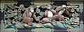
Hear no evil, speak no evil, see no evil

True Light Church, built 1916


- Cedar Avenue of Nikko
- Nikko Botanical Garden
- Tamozawa Imperial Villa
- Shrines and Temples of Nikkō (Nikkō Tōshō-gū, Futarasan Shrine, and Rinnō-ji)
- Nikkō Tōshō-gū
- The Three wise monkeys ("See no evil, hear no evil, speak no evil")
- Rinnō-ji
- Futarasan Shrine
- Lake Chūzenji
- Edo Wonderland Nikko Edomura (historical theme park)
- Nikko is well known for its monkeys that walk around the town in the winter looking for food.
- Jizō Bosatsu statues on the Kanman Walk. A little out of the main city, locals often tell visitors to count the statues while walking, and to recount while walking back. The number is often different, fueling a legend amongst locals.
- Kanmangafuchi Abyss is a place that was formed from the lava from the eruption of Mt. Nantai[11]
Sports[]

Nikkō is the home city to the Nikkō Ice Bucks in the Asia League Ice Hockey. Nikkō Kirifuri Ice Arena hosted the Women's Ice Hockey World Championships (Division I) in April 2007.
There is also a speed skating oval.
Sister city relations[]
 Rapid City, South Dakota, United States, sister city since February 7, 1993
 Tainan, Taiwan, friendship city since January 16, 2009
 Odawara, Kanagawa Prefecture, since December 19, 1980
Notable people[]
- Masaru Ibuka, entrepreneur, co-founder of Sony[12]
- Shoma Sato, professional baseball player[13]
- Akio Fukuda, politician[14]
- Tomikazu Fukuda, politician[15]
References[]
- ^ Jump up to: a b c "Nikkō City official statistics" (in Japanese). Nikkō City. 2 December 2020. Retrieved 3 January 2021.
- ^ "Nikko City/Location, Topography & History of Nikko City". Nikko City. Archived from the original on 2007-05-27. Retrieved 23 April 2008.
- ^ Lohn, Steve (11 September 1983). "Shrine of the Shogun". The New York Times.
- ^ "Nikko/Aizu - Challenging". okatours.com. Archived from the original on 2019-07-09. Retrieved 2019-07-09.
- ^ "NIKKO, 24-hr Average Temperature". worldclimate.com.
- ^ "NIKKO, Average Maximum Temperature". worldclimate.com.
- ^ "NIKKO, Average Minimum Temperature". worldclimate.com.
- ^ Nasu climate data
- ^ "Nikkō Climate Normals 1961–1990". National Oceanic and Atmospheric Administration. Retrieved January 5, 2013.
- ^ Jump up to: a b "Nikkō population statistics". 11 November 2018. Retrieved 3 January 2021.
- ^ "About Kanmangafuchi Abyss – Nikko Travel Guide | Planetyze". Planetyze. Retrieved 2017-11-24.
- ^ Kirkup, James. "Obituary: Masaru Ibuka," Independent (London). December 22, 1997.
- ^ [1] Baseball-reference.com
- ^ [2] Official home page (in Japanese)
- ^ official home page(in Japanese)
External links[]
 Media related to Nikko, Tochigi at Wikimedia Commons
 Nikko travel guide from Wikivoyage
- Official Website (in Japanese)
- Official Website at the Wayback Machine (archive index) (in Japanese)
- Nikko Tourist Association (in Japanese)
- Nikko Kinugawa Travel Guide
| show Authority control |
|---|
- Nikkō, Tochigi
- Cities in Tochigi Prefecture