Hinoemata, Fukushima
Hinoemata
檜枝岐村 | |
|---|---|
Village | |
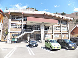 Hinoemata Village Hall | |
 Flag  Seal | |
 Location of Hinoemata in Fukushima Prefecture | |
 Hinoemata | |
| Coordinates: 37°1′26.9″N 139°23′20.2″E / 37.024139°N 139.388944°ECoordinates: 37°1′26.9″N 139°23′20.2″E / 37.024139°N 139.388944°E | |
| Country | Japan |
| Region | Tōhoku |
| Prefecture | Fukushima |
| District | Minamiaizu |
| Area | |
| • Total | 390.46 km2 (150.76 sq mi) |
| Population (January 2020) | |
| • Total | 556 |
| • Density | 1.4/km2 (3.7/sq mi) |
| Time zone | UTC+9 (Japan Standard Time) |
| - Tree | Chamaecyparis obtusa |
| - Flower | Asian skunk cabbage |
| Phone number | 0241-75-2311 |
| Address | 880 Shimonohara, Hinoemata-mura, Minamiaizu-gun, Fukushima-ken 967-0525 |
| Website | Official website |


Hinoemata (檜枝岐村, Hinoemata-mura) is a village located in Fukushima Prefecture, Japan. As of 1 January 2020, the village had an estimated population of 556, and a population density of 1.5 persons per km². The total area of the village was 390.46 square kilometres (150.76 sq mi). It is locally famous for its soba (buckwheat noodles) and known nationally for its kabuki performances and as a gateway to the Oze marshlands.
Geography[]
Located in the southwestern corner of Fukushima prefecture, Hinoemata is surrounded by the mountains Komagatake, Mount Taishaku, and Hiuchigatake (the highest mountain in northwestern Japan). Between these mountains runs the Hinoemata River. It is known for having the lowest population density of any municipality in Japan.
- Mountains: Aizu-Komagatake (2133 m), Mount Taishaku (2060 m), Hiuchigatake (2356 m)
- Rivers: Hinoemata River
- Lakes: Ozegahara
Neighboring municipalities[]
- Fukushima Prefecture
- Tadami
- Minamiaizu
- Niigata Prefecture
- Uonuma
- Gunma Prefecture
- Tochigi Prefecture
Climate[]
Hinoemata has a humid continental climate (Köppen Dfb) characterized by warm summers and cold winters with heavy snowfall. The average annual temperature in Hinoemata is 6.5 °C. The average annual rainfall is 1050 mm with September as the wettest month. The temperatures are highest on average in August, at around 19.2 °C, and lowest in January, at around -5.2 °C.[1]
| hideClimate data for Hinoemata (elevation 973 m (3,192 ft)) | |||||||||||||
|---|---|---|---|---|---|---|---|---|---|---|---|---|---|
| Month | Jan | Feb | Mar | Apr | May | Jun | Jul | Aug | Sep | Oct | Nov | Dec | Year |
| Record high °C (°F) | 10.3 (50.5) |
14.0 (57.2) |
16.6 (61.9) |
25.2 (77.4) |
29.4 (84.9) |
31.2 (88.2) |
32.5 (90.5) |
32.5 (90.5) |
30.5 (86.9) |
26.9 (80.4) |
22.0 (71.6) |
19.7 (67.5) |
32.5 (90.5) |
| Average high °C (°F) | −0.1 (31.8) |
0.6 (33.1) |
4.3 (39.7) |
11.7 (53.1) |
18.3 (64.9) |
21.7 (71.1) |
25.1 (77.2) |
26.5 (79.7) |
21.6 (70.9) |
15.5 (59.9) |
9.6 (49.3) |
3.5 (38.3) |
13.2 (55.8) |
| Daily mean °C (°F) | −3.9 (25.0) |
−3.7 (25.3) |
−0.5 (31.1) |
5.4 (41.7) |
11.5 (52.7) |
15.7 (60.3) |
19.3 (66.7) |
20.2 (68.4) |
16.0 (60.8) |
9.6 (49.3) |
4.0 (39.2) |
−0.9 (30.4) |
7.7 (45.9) |
| Average low °C (°F) | −7.9 (17.8) |
−8.1 (17.4) |
−5 (23) |
0.4 (32.7) |
5.4 (41.7) |
10.5 (50.9) |
14.8 (58.6) |
15.6 (60.1) |
11.8 (53.2) |
5.0 (41.0) |
−0.3 (31.5) |
−4.9 (23.2) |
3.1 (37.6) |
| Record low °C (°F) | −18.7 (−1.7) |
−18.2 (−0.8) |
−17 (1) |
−10.2 (13.6) |
−4 (25) |
2.0 (35.6) |
5.4 (41.7) |
6.6 (43.9) |
−0.2 (31.6) |
−5.1 (22.8) |
−10 (14) |
−16 (3) |
−18.7 (−1.7) |
| Average precipitation mm (inches) | 125.8 (4.95) |
109.5 (4.31) |
89.6 (3.53) |
78.9 (3.11) |
91.8 (3.61) |
124.6 (4.91) |
187.1 (7.37) |
166.5 (6.56) |
170.8 (6.72) |
138.5 (5.45) |
106.6 (4.20) |
125.5 (4.94) |
1,505.4 (59.27) |
| Mean monthly sunshine hours | 46.5 | 61.1 | 95.0 | 130.4 | 149.3 | 124.6 | 126.7 | 133.1 | 90.6 | 84.6 | 70.1 | 52.1 | 1,160 |
| Source 1: Japan Meteorological Agency (1981 - 2010)[2] | |||||||||||||
| Source 2: Japan Meteorological Agency (1976 - 2019)[3] | |||||||||||||
Demographics[]
Per Japanese census data,[4] the population of Hinoemata peaked around the year 1960 and has declined steadily over the past 60 years.
| Year | Pop. | ±% |
|---|---|---|
| 1920 | 463 | — |
| 1930 | 532 | +14.9% |
| 1940 | 691 | +29.9% |
| 1950 | 786 | +13.7% |
| 1960 | 983 | +25.1% |
| 1970 | 851 | −13.4% |
| 1980 | 765 | −10.1% |
| 1990 | 702 | −8.2% |
| 2000 | 757 | +7.8% |
| 2010 | 637 | −15.9% |
History[]
The area of present-day Hinoemata was part of ancient Mutsu Province and formed part of the holdings of Aizu Domain during the Edo period. After the Meiji Restoration, it was organized as part of Minamiaizu District in Fukushima Prefecture. Hinoemata was formed on April 1, 1889 with the establishment of the modern municipalities system.
Economy[]
The economy of Hinoemata is primarily agricultural.
Education[]
Hinoemata has one public elementary school and one public junior high school operated by the village government.
- Hinoemata Elementary School
- Hinoemata Intermediate School
Transportation[]
Railway[]
Hinoemata does not have any passenger train service.
Highway[]
Bus[]
Hinoemata is served by a single local bus line connecting it with Aizukogenozeguchi and Aizu-Tajima stations in neighboring Minami-Aizu Town.[5]
Local attractions[]
- Okutadami Dam (Hinoemata is situated on the east bank of the dam lake.) While half the dam is technically within Hinoematta the Dam is not accessible to the public from the Hinoematta side due to mountainous terrain.
- Hinoemata Hot Spring
- Sanjō Falls
- Takeda Hisayoshi Memorial Hall
References[]
- ^ Hinoemata climate data
- ^ 桧枝岐 年・月ごとの平年値 (in Japanese). Japan Meteorological Agency. Retrieved 21 February 2019.
- ^ 桧枝岐 観測史上1~10位の値 (in Japanese). Japan Meteorological Agency. Retrieved 21 February 2019.
- ^ Hinoemata population statistics
- ^ "路線バス時刻表(Pdf版)".
External links[]
![]() Media related to Hinoemata, Fukushima at Wikimedia Commons
Media related to Hinoemata, Fukushima at Wikimedia Commons
- Official Website (in Japanese)
- Hinoemata Village(Oku-Aizu.net)
| show Authority control |
|---|
- Hinoemata, Fukushima
- Villages in Fukushima Prefecture