Tamura, Fukushima
Tamura
田村市 | |
|---|---|
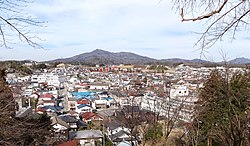 Central Tamura (2015) | |
 Flag  Seal | |
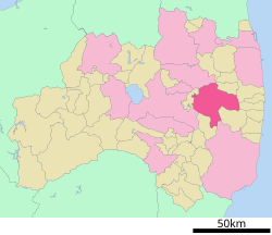 Location of Tamura in Fukushima Prefecture | |
 Tamura | |
| Coordinates: 37°26′N 140°34′E / 37.433°N 140.567°ECoordinates: 37°26′N 140°34′E / 37.433°N 140.567°E | |
| Country | Japan |
| Region | Tōhoku |
| Prefecture | Fukushima |
| Government | |
| • Mayor | Jinichi Honda |
| Area | |
| • Total | 458.30 km2 (176.95 sq mi) |
| Population (March 2020) | |
| • Total | 35,702 |
| • Density | 78/km2 (200/sq mi) |
| Time zone | UTC+9 (Japan Standard Time) |
| - Tree | Oak |
| - Flower | Azalea |
| - Bird | Japanese bush warbler |
| Phone number | 0247-82-1111 |
| Address | 76 Funehikimachi Funehiki aza hatazoe, Tamura-shi, Fukushima-ken 963-4393 |
| Website | Official website |


Tamura (田村市, Tamura-shi) is a city located in Fukushima Prefecture, Japan. As of 1 March 2020, the city had an estimated population of 35,702 in 12,821 households[1] and a population density of 78 persons per km². The total area of the city was 458.30 square kilometres (176.95 sq mi).
Geography[]
Tamura is located in east-central Fukushima Prefecture, in the easternmost portion of the Nakadōri region of then prefecture. The town is located in an hilly region of the Abukuma Mountains.
Neighboring municipalities[]
Demographics[]
Per Japanese census data,[2] the population of Tamura has declined steadily over the past 60 years.
| Year | Pop. | ±% |
|---|---|---|
| 1960 | 58,820 | — |
| 1970 | 52,926 | −10.0% |
| 1980 | 48,932 | −7.5% |
| 1990 | 46,758 | −4.4% |
| 2000 | 45,054 | −3.6% |
| 2010 | 40,422 | −10.3% |
Climate[]
Tamura has a humid continental climate (Köppen Cfa) characterized by mild summers and cold winters with heavy snowfall. The average annual temperature in Tamura is 10.4 °C. The average annual rainfall is 1368 mm with September as the wettest month. The temperatures are highest on average in August, at around 23.1 °C, and lowest in January, at around -0.1 °C.[3]
History[]
The area of present-day Tamura was part of ancient Mutsu Province. Much of the area was part of Miharu Domain under the Edo period Tokugawa shogunate. After the Meiji Restoration, the area was organized as part of Tamura District in Iwaki Province. The villages of Miyakoji, Tokiwa, Katasone, Takine, and Ōgoe were established with the creation of the modern municipalities system on April 1, 1889. Tokiwa was elevated to town status on July 1, 1898, and the village of Katasone became the town of Funehiki on April 1, 1934. Takine was elevated to town status of April 1, 1940 followed by Ōgoe on February 8, 1942. The city of Tamura was established on March 1, 2005, from the merger of these four towns and one village.
Evacuation after the Fukushima Daiichi Nuclear Disaster[]
After the Fukushima Daiichi Nuclear Disaster on 11 March 2011, the area containing the former village of Miyakoji was evacuated. On 1 April 2012 residents were allowed to return during daytime hours as decontamination work progressed. The evacuation order was lifted on 1 April 2014.[4] However, doubts remain as to the effectiveness of the radiation decontamination efforts.[5][6][7] [8]
Government[]
Tamura has a mayor-council form of government with a directly elected mayor and a unicameral city legislature of 20 members. Tamura, together with Tamura District contribute two members to the Fukushima Prefectural Assembly. In terms of national politics, the city is part of Fukushima 3rd district of the lower house of the Diet of Japan.
Economy[]
The economy of Tamura is primarily agricultural. Rice, beef and dairy cattle, and vegetable production predominates. The area is also known for its bottled mineral water and sake rice wine.
Education[]
Tamura has 16 public elementary schools and seven public junior high school operated by the city government, and one public high school operated by the Fukushima Board of Education.
- Fukushima Prefectural Funehiki High School
Transportation[]
Railway[]
Highway[]
International relations[]
 Mansfield, Ohio, United States, since October 21, 2000
Local attractions[]

- Abukuma Limestone Caves
- Hoshi no Mura ("Village of Stars") Observatory
- Ohtakadoyayama Transmitter is an LF-time signal transmitter in Miyakoji-machi. It is used for transmitting the time signal JJY on 40 kHz. It uses as transmission antenna a 250 metre tall guyed mast with an umbrella antenna, which is insulated against ground.
Noted people from Tamura[]
- Hiroyuki Arai, politician
- Kōichirō Genba, politician
References[]
- ^ Tamura City official statistics(in Japanese)
- ^ Tamura population statistics
- ^ Tamura climate data
- ^ World Nuclear News (1 April 2014) First Fukushima residents go home to Miyakoji
- ^ The Asahi Shimbun (23 March 2013)Fukushima cleanup contractors told workers to lie about pay in 'surprise' inspections Archived 2014-11-25 at the Wayback Machine
- ^ The Mainich Shimbun (08 June 2013) Data reveals that 75 percent of decontamination work in housing areas remains unfinished Archived 2013-07-01 at archive.today
- ^ The Mainichi Shimbun (27 May 2013) Subcontractor chided for sacking Fukushima decontamination work whistle-blowers Archived 2013-07-01 at archive.today
- ^ The Asahi Shimbun (29 June 2013) Government offers dosimeters--not decontamination--for Fukushima evacuees Archived 2015-01-05 at the Wayback Machine
External links[]
 Media related to Tamura, Fukushima at Wikimedia Commons
- Official Website (in Japanese)
- JJY at Tamura
| show Authority control |
|---|
- Tamura, Fukushima
- Cities in Fukushima Prefecture