Yakushima
Native name: Japanese: 屋久島 | |
|---|---|
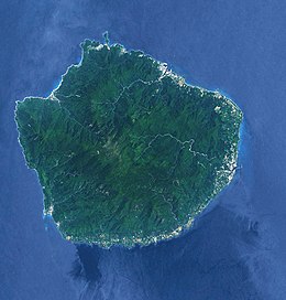 Landsat image of Yakushima | |
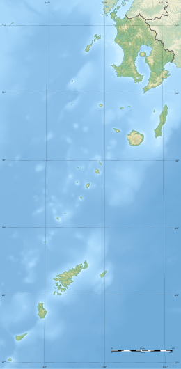
 Yakushima Location in Japan (with southern islands in inset) | |
| Geography | |
| Location | East China Sea |
| Coordinates | 30°20′38″N 130°31′26″E / 30.34389°N 130.52389°ECoordinates: 30°20′38″N 130°31′26″E / 30.34389°N 130.52389°E |
| Archipelago | Ōsumi Islands |
| Area | 504.88 km2 (194.94 sq mi) |
| Highest elevation | 1,936 m (6352 ft) |
| Highest point | Mount Miyanoura |
| Administration | |
| Kagoshima Prefecture | |
| Demographics | |
| Population | 13,178 (2010) |
| Pop. density | 26.1/km2 (67.6/sq mi) |
| Ethnic groups | Japanese |
| Criteria | Natural: vii, ix |
| Reference | 662 |
| Inscription | 1993 (17th Session) |
| Area | 10,747 ha |
| Official name | Yakushima Nagata-hama |
| Designated | 8 November 2005 |
| Reference no. | 1559[1] |

Yakushima (屋久島) is one of the Ōsumi Islands in Kagoshima Prefecture, Japan. The island, 504.88 km2 (194.94 sq mi) in area, has a population of 13,178. Access to the island is by hydrofoil ferry (7 or 8 times a day from Kagoshima, depending on the season), slow car ferry (once or twice a day from Kagoshima), or by air to Yakushima Airport (3 to 5 times daily from Kagoshima, once daily from Fukuoka and once daily from Osaka). Administratively, the whole island is the town of Yakushima. The town also serves neighbouring Kuchinoerabujima. The majority of the island is within the borders of the Kirishima-Yaku National Park.[2]
Yakushima's electricity is more than 50% hydroelectric, and surplus power has been used to produce hydrogen gas in an experiment by Kagoshima University. The island has been a test site for Honda's hydrogen fuel cell vehicle research. (There are no hydrogen cars stationed on the island but electric cars are run by the municipality.)
World Heritage designation[]
In 1980 an area of 18,958 ha (46,850 acres) was designated a UNESCO Man and the Biosphere Reserve.[3] In 1993, 10 hectares (25 acres) of wetland at Nagata-hama was designated a Ramsar Site.[4] It is the largest nesting ground for the endangered loggerhead sea turtle in the North Pacific.[2][5] Yakushima's unique remnant of warm/temperate ancient forest has been a natural World Heritage Site since 1993. In the Wilderness core area (12.19 square kilometres (3,010 acres)) of the World Heritage Site, no record of past tree cutting can be traced.[6] The island is visited by 300,000 tourists every year.
Geography[]
Yakushima is located approximately 61.3 kilometres (38.1 mi) south of the southern tip of Ōsumi Peninsula in southern Kyushu, or 135 kilometres (73 nmi) south of Kagoshima. The Vincennes Strait (Yakushima Kaikyō) separates it from the nearby island of Tanegashima, which is home to the Japanese Space Centre. Periodic rocket launches from Tanegashima can clearly be seen from Yakushima.
The bedrock of the island is granite, and as such it hosts no active volcanoes.[7] It has an area of approximately 504.5 square kilometres (194.8 sq mi). The island is roughly circular in shape, with a circumference of 89 kilometres (55 mi) and a diameter of 28 kilometres (17 mi). The highest elevations on the island are Miyanouradake (宮之浦岳), with a height of 1,935 metres (6,348 ft), and Nagatadake (永田岳), with a height of 1,886 metres (6,188 ft) above sea level; however, Yakushima has another 30 peaks of over 1,000 metres (3,300 ft) in height. There are numerous hot springs on the island.

History[]
Yakushima has been settled since at least the Jōmon period. It was first mentioned in written documents of the Chinese Sui Dynasty of the 6th century, and in the Japanese Shoku Nihongi in an entry dated 702 CE. It formed part of ancient Tane Province. It was often mentioned in the diaries of travelers between Tang Dynasty China and Nara period Japan.
During the Edo period, Yakushima was ruled by the Shimazu clan of the Satsuma Domain and was considered part of Ōsumi Province. Following the Meiji restoration, the island has been administered as part of Kagoshima Prefecture.
In 2017, Yakushima was struck by Typhoon Noru causing one death.
Demographics and economics[]
The population of Yakushima reached a peak in 1960 with 24,010 inhabitants. It thereafter declined until about 1995, but has subsequently stabilized at just over 13,000 inhabitants.
Traditionally, the economic mainstays of the population were forestry and the export of wood products (principally cedar roof shingles), and commercial fishing. Cultivation of oranges and tea, the distilling of shōchū, and tourism are now the main sources of income.[citation needed]
Flora and fauna[]

Yakushima contains one of the largest tracts of existing Nansei Islands subtropical evergreen forests, an endangered habitat ecoregion.[8] The only large animals indigenous to the island are red-bottomed macaques (Yakushima macaque) and a variety of sika deer (yakushika). The Japanese raccoon dog is also a common animal, but is not native to the island. Japanese weasels (Mustela itatsi) may also be seen from time to time. The island is a spawning ground for migratory loggerhead turtles, and dolphins are to be found offshore. The coastal areas have coral reefs in places, although to a much lesser extent than are found farther south in the islands of Okinawa. The island, along with neighbouring Tanegashima, has been recognised as an Important Bird Area (IBA) by BirdLife International because they support populations of Japanese wood pigeons, Ryukyu green pigeons and Ryukyu robins.[9]
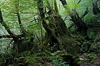
Yakushima is famous for its lush vegetation. Most of the island has at one time or another been logged (dating back at least to the early Edo period), but has been extensively replanted and reseeded since logging ended in the late 1960s, at which time a conservation regime was established. In addition to this secondary forest, there are some remaining areas of primary forest, composed mainly of a variety of Cryptomeria japonica, or Japanese cedar, known as yakusugi (屋久杉), the best known single example of which is named the Jōmon Sugi (縄文杉), as its age is estimated to date to at least the Jōmon period of Japanese history, 2300 years ago. In addition, the island lists over 50 varieties of endemic flower, notably rhododendrons, and hundreds of rare endemic Bryophyta, as well as a number of endemic trees.

Climate[]
Yakushima has a humid subtropical climate (Köppen climate classification Cfa) with hot, humid summers and mild winters. Precipitation is extremely heavy, with at least 250 millimetres (9.8 in) in each month and as much as 773 millimetres (30.4 in) in June alone. Yakushima is Japan's wettest place,[10] and annual precipitation in Yakushima is one of the world's highest at 4,000 to 10,000 mm (160 to 390 in). It is said by the locals to rain "35 days a month". There are drier periods in autumn and winter, while the heaviest downpours occur in spring and summer, often accompanied by landslides. It is the southernmost place in Japan where there is snow in the mountains, often for months, while the ocean temperature is never below 19 °C (66 °F)
| hideClimate data for Yakushima (1991−2020 normals, extremes 1937−present) | |||||||||||||
|---|---|---|---|---|---|---|---|---|---|---|---|---|---|
| Month | Jan | Feb | Mar | Apr | May | Jun | Jul | Aug | Sep | Oct | Nov | Dec | Year |
| Record high °C (°F) | 25.3 (77.5) |
26.1 (79.0) |
29.6 (85.3) |
29.8 (85.6) |
31.9 (89.4) |
34.8 (94.6) |
35.2 (95.4) |
35.4 (95.7) |
34.7 (94.5) |
31.3 (88.3) |
30.7 (87.3) |
26.6 (79.9) |
35.4 (95.7) |
| Average high °C (°F) | 14.7 (58.5) |
15.5 (59.9) |
18.0 (64.4) |
21.4 (70.5) |
24.5 (76.1) |
26.9 (80.4) |
30.5 (86.9) |
30.9 (87.6) |
28.9 (84.0) |
25.2 (77.4) |
21.2 (70.2) |
16.8 (62.2) |
22.9 (73.2) |
| Daily mean °C (°F) | 11.8 (53.2) |
12.3 (54.1) |
14.6 (58.3) |
17.8 (64.0) |
21.0 (69.8) |
23.7 (74.7) |
27.0 (80.6) |
27.5 (81.5) |
25.7 (78.3) |
22.2 (72.0) |
18.2 (64.8) |
13.9 (57.0) |
19.6 (67.3) |
| Average low °C (°F) | 8.9 (48.0) |
9.2 (48.6) |
11.3 (52.3) |
14.2 (57.6) |
17.5 (63.5) |
21.0 (69.8) |
23.9 (75.0) |
24.6 (76.3) |
22.8 (73.0) |
19.4 (66.9) |
15.2 (59.4) |
11.0 (51.8) |
16.6 (61.9) |
| Record low °C (°F) | 1.0 (33.8) |
0.7 (33.3) |
1.5 (34.7) |
4.5 (40.1) |
10.1 (50.2) |
13.7 (56.7) |
18.3 (64.9) |
19.6 (67.3) |
15.2 (59.4) |
9.1 (48.4) |
5.6 (42.1) |
2.2 (36.0) |
0.7 (33.3) |
| Average precipitation mm (inches) | 294.6 (11.60) |
289.2 (11.39) |
387.0 (15.24) |
405.5 (15.96) |
444.1 (17.48) |
860.3 (33.87) |
362.4 (14.27) |
256.5 (10.10) |
450.7 (17.74) |
309.9 (12.20) |
309.6 (12.19) |
281.8 (11.09) |
4,651.7 (183.14) |
| Average snowfall cm (inches) | 0 (0) |
0 (0) |
0 (0) |
0 (0) |
0 (0) |
0 (0) |
0 (0) |
0 (0) |
0 (0) |
0 (0) |
0 (0) |
0 (0) |
0 (0) |
| Average precipitation days (≥ 0.5 mm) | 17.2 | 15.2 | 16.2 | 13.5 | 13.7 | 19.6 | 12.5 | 14.6 | 15.5 | 12.8 | 12.8 | 15.8 | 179.3 |
| Average relative humidity (%) | 68 | 68 | 69 | 71 | 76 | 85 | 83 | 82 | 81 | 74 | 71 | 69 | 75 |
| Mean monthly sunshine hours | 74.9 | 83.2 | 117.9 | 146.2 | 152.7 | 100.0 | 209.9 | 201.3 | 139.8 | 115.9 | 97.3 | 78.8 | 1,515.8 |
| Source: Japan Meteorological Agency[11] | |||||||||||||
Pollution[]
According to a disputed theory, airborne pollutants from the People's Republic of China may have affected Yakushima white pine in the forest on the island.[12] The scientific results have been published: "Environmental factors influencing the load of long-range transported air pollutants on Pinus amamiana in Yakushima Island, Japan" IN: January 2009 Ecological Research 25(1):233-243.
Transportation[]
Airport[]
Yakushima Airport is the main airport that serves the island.
Ferries[]
Tanegayaku High Speed Ship Jetfoil "Toppy" "Rocket"
- Kagoshima Port, Minato Pier, Kagoshima City- Ibusuki Port ( Ibusuki City ) in Tanegashima, Nishinoomote Port ( Nishinoomote City ), Yakushima, Miyanoura Port or Anbo Port.
Other[]
- Orita Kisen “Ferry Yakushima 2”
- Kagoshima Minato-ku Minami Pier-Yakushima / Miyanoura Port
- Kagoshima Merchant Ship & Shinyashiki Shoji Ferry "Haibisukasu" [40]
- Taniyama Port 2 Ward (Kagoshima City)-Tanegashima Nishinoomote Port (Nishinoomote City)-Yakushima Miyanoura Port
- Forward (Taniyamako onset) after arriving in Nishinoomote Port at night Todokohaku, the next morning to go to Miyanoura Port [41] .
- Yakushima Town "Ferry Taiyo"
- Kuchinoerabujima -Yakushima / Miyanoura Port-Tanegashima / Shimama Port ( Minamitanemachi )
Buses[]
The number of bus services is relatively high in Tanegashima and Yakushima. They operate from morning till evening. However, there are very few buses on each route.
Cars[]
There are several rental car companies. The northwestern road called the Western Forest Road is a narrow road which is difficult for cars to pass each other. The road is closed due to steep curves and steep slopes. The gas prices on the island is several tens of yen higher than the Japanese mainland.
Railway[]
The last operating narrow gauge (762mm gauge) timber railway in Japan is on the island but it is freight only. Several other lines did operate but are now closed. The track is used by some hikers as a path but this can be dangerous as the line is very much still in operation.
Onsen[]
There are several onsen (hot springs) on Yakushima.
- Onoma Onsen
- Yakushima Onsen
- Hirauchi underwater hot spring
- Yudomari Onsen
- Oura hot spring - originally a hot spring, but it's now a communal bath with boiling spring water
- Yodogawa Onsen
- Yunoko no Yu
- Jomon no Yado Manten - outpatient Bathing
In popular culture[]
- The forests of Yakushima inspired the forest setting in Hayao Miyazaki's film Princess Mononoke.[13]
- Yakushima is the inspiration behind the forest of Dremuchij in Metal Gear Solid 3: Snake Eater.[14]
- Fictional characters Jun and Jin Kazama of Tekken lived on Yakushima.[citation needed]
- Eiji Miyake, the protagonist of David Mitchell's novel number9dream, is from Yakushima. Parts of the novel take place in the narrator's childhood on the island.
- The island also featured prominently in the 1996 film Rebirth of Mothra. In the movie The Young Mothra swims to the island to transform into the new and more powerful Mothra taking its life essence and new powers from the eternal forest.
- Characters in Persona 3 take a week's vacation on Yakushima.
See also[]
- Ernest Henry Wilson - Wilson stump
- List of Special Places of Scenic Beauty, Special Historic Sites and Special Natural Monuments
- List of World Heritage Sites in Japan
- List of national parks of Japan
- Ramsar sites in Japan
References[]
- Witham, Clive. Yakushima: A Yakumonkey Guide. Siesta Press. (2009) ISBN 0956150705
External links[]
| Wikimedia Commons has media related to Yakushima. |
| Wikivoyage has a travel guide for Yakushima. |
Notes[]
- ^ "Yakushima Nagata-hama". Ramsar Sites Information Service. Retrieved 25 April 2018.
- ^ Jump up to: a b "Introducing places of interest: Kirishima-Yaku National Park". Ministry of the Environment. Retrieved 24 March 2011.
- ^ "Biosphere Reserve Information - Yakushima". UNESCO. Retrieved 29 April 2011.
- ^ "Ramsar Sites in Japan - Yakushima Nagata-hama" (PDF). Ministry of the Environment. Retrieved 24 March 2011.
- ^ "Kirishima-Yaku National Park". Natural Parks Foundation. Retrieved 24 March 2011.
- ^ "World Heritage Nomination - IUCN Summary" (PDF). UNESCO World Heritage Committee. Retrieved 2008-08-28.
- ^ "World Heritage Sites in Japan". www.jnto.go.jp.
- ^ "Nansei Islands subtropical evergreen forests". Global Species. Myers Enterprises II. Retrieved 23 July 2017.
- ^ "Yakushima and Tanegashima islands". BirdLife Data Zone. BirdLife International. 2021. Retrieved 7 February 2021.
- ^ "Japan Climate Charts Index".
- ^ 気象庁 / 平年値(年・月ごとの値). Japan Meteorological Agency. Retrieved May 19, 2021.
- ^ Martin Fackler (April 24, 2013). "Scientist Says Pollution From China Is Killing a Japanese Island's Trees". The New York Times. Retrieved April 25, 2013.
- ^ "World Heritage - Yakushima". Japan Airlines. Retrieved 2008-08-15.
- ^ [1], Hideo Kojima offers insight and commentary on Metal Gear Solid 3: Snake Eater.
| show Authority control |
|---|
- Ōsumi Islands
- Islands of Kagoshima Prefecture
- Biosphere reserves of Japan
- Cultural Landscapes of Japan
- Ramsar sites in Japan
- Tourist attractions in Kagoshima Prefecture
- World Heritage Sites in Japan
- Important Bird Areas of the Nansei Islands