Saint Peter Port
Saint Peter Port
Saint-Pierre-Port | |
|---|---|
         Photos of St Peter Port | |
 Flag  Seal | |
 Location of Saint Peter Port in Guernsey | |
| Coordinates: 49°27′20″N 2°32′12″W / 49.4555°N 2.5368°WCoordinates: 49°27′20″N 2°32′12″W / 49.4555°N 2.5368°W | |
| Crown Dependency | Guernsey, Channel Islands |
| Government | |
| • Electoral district | Divided into St Peter Port North and St Peter Port South |
| Area | |
| • Total | 6.5 km2 (2.5 sq mi) |
| Elevation | 0 m (0 ft) |
| Population (2019) | |
| • Total | 18,958 |
| • Density | 2,900/km2 (7,600/sq mi) |
| Time zone | GMT |
| • Summer (DST) | UTC+01 |
| Postal code | GY1 |
| Website | www |

St. Peter Port (French: Saint-Pierre Port) is a town and one of the ten parishes on the island of Guernsey in the Channel Islands. It is the capital of the Bailiwick of Guernsey as well as the main port. The population in 2019 was 18,958.
St. Peter Port is a small town (commonly referred to by locals as just "town")[1] consisting mostly of steep narrow streets and steps on the overlooking slopes. It is known that a trading post/town existed here before Roman times with a pre-Christian name which has not survived.
The parish covers an area of 6.5 km2. The postal code for addresses in the parish starts with GY1.
People from St. Peter Port, were nicknamed "les Villais" (the townspeople) or "cllichards" in Guernésiais.
Geography[]
St. Peter Port is on the east coast of Guernsey overlooking Herm and tiny Jethou, a further channel separates Sark and surrounding islets such as Brecqhou; exceptionally Normandy's long Cotentin Peninsula and, to the south-east, Jersey are visible in clear conditions beyond from some, highest, vantage points. The parish borders St. Sampson in the north, The Vale in the north-west, St. Andrew in the west and St. Martin in the south.
The name of the nearest channel is the Little Russel, in which sits the Bréhon Tower; that separating Sark is the Big Russel. Both in width are less than half of Guernsey's greatest length and dotted with coastal rocks and stacks quite near those islands, some of which are narrowly submerged.
- Relief
The land in the north and by the harbour is low-lying but not marshy. In the south, the land gets higher (but not as high as St Martin's or the Forest). Grassy, gently terraced cliffs behind sea walls (including projections) topped by trees characterise the southern part of the coast here (by an aquarium, underground military museum and historic battery at semi-wooded Havelet). In the north is the retail-centred and more built-up /Admiral Park coastal locality. To the south of the town lies Havelet Bay and the coast path which leads to the very pretty Fermain Bay after a walk of about 20–25 minutes.
Climate[]
St. Peter Port has an oceanic climate (Cfb) with mild summers and cool winters.
| hideClimate data for St. Peter Port (2010-2020 normals, extremes 1947–present) | |||||||||||||
|---|---|---|---|---|---|---|---|---|---|---|---|---|---|
| Month | Jan | Feb | Mar | Apr | May | Jun | Jul | Aug | Sep | Oct | Nov | Dec | Year |
| Record high °C (°F) | 13.3 (55.9) |
15.0 (59.0) |
19.4 (66.9) |
24.3 (75.7) |
25.9 (78.6) |
30.8 (87.4) |
32.6 (90.7) |
34.3 (93.7) |
30.6 (87.1) |
23.6 (74.5) |
18.0 (64.4) |
15.6 (60.1) |
34.3 (93.7) |
| Average high °C (°F) | 8.7 (47.7) |
8.4 (47.1) |
10.0 (50.0) |
12.6 (54.7) |
14.8 (58.6) |
17.6 (63.7) |
20.0 (68.0) |
19.5 (67.1) |
18.3 (64.9) |
15.4 (59.7) |
11.9 (53.4) |
10.1 (50.2) |
13.9 (57.0) |
| Daily mean °C (°F) | 7.4 (45.3) |
6.7 (44.1) |
7.9 (46.2) |
9.9 (49.8) |
12.1 (53.8) |
14.7 (58.5) |
17.0 (62.6) |
16.9 (62.4) |
15.8 (60.4) |
13.5 (56.3) |
10.4 (50.7) |
8.7 (47.7) |
11.8 (53.2) |
| Average low °C (°F) | 5.9 (42.6) |
5.2 (41.4) |
5.8 (42.4) |
7.2 (45.0) |
9.4 (48.9) |
11.9 (53.4) |
14.0 (57.2) |
14.3 (57.7) |
13.3 (55.9) |
11.6 (52.9) |
8.9 (48.0) |
7.4 (45.3) |
9.6 (49.3) |
| Record low °C (°F) | −7.8 (18.0) |
−7.2 (19.0) |
−2.2 (28.0) |
−1.4 (29.5) |
0.1 (32.2) |
5.4 (41.7) |
8.3 (46.9) |
9.2 (48.6) |
5.8 (42.4) |
3.5 (38.3) |
−0.8 (30.6) |
−3.8 (25.2) |
−7.8 (18.0) |
| Average precipitation mm (inches) | 90.7 (3.57) |
73.1 (2.88) |
50.5 (1.99) |
38.9 (1.53) |
43.6 (1.72) |
37.8 (1.49) |
33.3 (1.31) |
53.6 (2.11) |
52.3 (2.06) |
82.5 (3.25) |
97.8 (3.85) |
99.5 (3.92) |
753.6 (29.67) |
| Average precipitation days (≥ 0.2 mm) | 20.8 | 18.1 | 14.2 | 10.2 | 10.8 | 11.4 | 10.4 | 13.9 | 12.8 | 17.2 | 20.7 | 20.3 | 180.9 |
| Average snowy days | 1.0 | 1.0 | 1.0 | 0.6 | 0.0 | 0.0 | 0.0 | 0.0 | 0.0 | 0.0 | 0.0 | 1.0 | 4.6 |
| Mean monthly sunshine hours | 61.0 | 85.6 | 127.6 | 194.7 | 234.5 | 246.6 | 250.7 | 230.1 | 180.1 | 117.1 | 77.8 | 58.2 | 1,864 |
| Percent possible sunshine | 22.7 | 29.1 | 34.7 | 47.7 | 49.6 | 51.2 | 51.7 | 52.0 | 47.8 | 35.3 | 28.7 | 22.8 | 41.8 |
| Source 1: Guernsey Met Office 2018 Weather Report[2] | |||||||||||||
| Source 2: Weather-online.co.uk[3] | |||||||||||||
Subdivisions[]

Saint Peter Port is subdivided into four cantons:[4]
- Canton 1 or North Canton
- Canton 2 or Canton of the North-West
- Canton 3 or Canton of the South-West
- Canton 4 or Canton of the South
In addition, the islands of Herm and Jethou belong to the parish,[5] but are not part of any canton. They belong to Electoral district Saint Peter Port South.[6]
Sport and leisure[]
St. Peter Port has an English Isthmian League club, Guernsey F.C. who play at Footes Lane. The Guernsey Rugby Football Club also play at Footes Lane and compete in National League 3 London & SE.
Parks and gardens[]
Candie Gardens, an award-winning restored Victorian Garden features a statue of Victor Hugo. Cambridge Park is a recreational park that includes a skate park. In 2014 the parish was a Gold & Category Winner in the RHS Britain in Bloom competition,[7] followed in 2016 with another Gold medal.[8]
Features[]
|
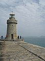
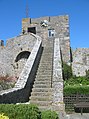
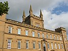
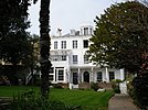
The features of the town include:
|
The parish of Saint Peter Port hosts:
 The Town Church  Liberation Monument
|
Main roads[]
The following main roads (listed from north-south) provide important links between St Peter Port and the other parishes:
- Les Banques (leads up the coast to St Sampson's and the north of the island)
- Rohais (leads to the parish of Castel)
- Mount Row (leads to St Andrew's and the west of the island)
- Ruette Brayes (leads to St Martin's and the south of the island)
- Fort Road (leads to St Martin's)
The following coastal roads (listed from north to south) are also very important as they provide access to the shops, carparks and the harbour:
- St George's Esplanade
- North Esplanade
- South Esplanade
- Mount Durand
Politics[]
Saint Peter Port comprises two administrative division, St Peter Port South and St Peter Port North.
In the 2016 Guernsey general election in:
- St Peter Port South there was a 2,068 or 63% turnout to elect five Deputies
- St Peter Port North there was a 2,639 or 65% turnout to elect six Deputies.
Notable people[]
- Margaret Ann Neve - Supercentenarian and the oldest woman in the world until her death in 1903
- Sir Isaac Brock – Major General, "Hero of Upper Canada", War of 1812
- Matthew Le Tissier, footballer
- Alison Merrien MBE, World indoors bowls champion
- George Métivier, poet
- Heather Watson, tennis player, Team GB athlete and Wimbledon Champion
- Victor Hugo, French writer, In exile in St-Peter Port from 1855 to 1870.
- Cameron Chalmers, athlete
Numismatic History[]
Guernsey bank notes feature a number of parish buildings:
|
|
See also[]
| Wikimedia Commons has media related to Saint Peter Port. |
References[]
- ^ "St Peter Port Guernsey | Guernsey's Capital". www.visitguernsey.com. Retrieved 2021-08-30.
- ^ "2014 Weather Report" (PDF). Guernsey Met Office. Archived (PDF) from the original on 21 November 2019. Retrieved 20 November 2019.
- ^ "Normals 2010-2020". Weather-online. Retrieved 3 February 2020.
- ^ "St. Peter Port Parish, Canton Boundaries". Stppcons.com. 2007-11-14. Retrieved 2012-10-04.
- ^ "Bailiwick of Guernsey". Crwflags.com. Retrieved 2012-10-04.
- ^ "Guernsey Election of States Deputies, 2008". Islandlife.org. 2008-04-23. Retrieved 2012-10-04.
- ^ "RHS Britain in Bloom 2014 UK Finals Judges' Reports". Britain in Bloom.
- ^ "RHS Britain in Bloom 2016 UK Finals Full Results". RHS Britain in Bloom.
- ^ "Places to visit". National Trust of Guernsey.
- ^ "Victoria Tower". Guernsey Museums. 15 October 2012.
- ^ Jump up to: a b c "Townie No 1" (PDF).
- ^ "Guilles Alles Library". Archived from the original on 2015-12-07.
- ^ "Candie Museum". Guernsey Museums. 12 July 2012.
- ^ "Candie Gardens". Guernsey Museums. 19 July 2012.
- ^ "German Naval Signals HQ".
- ^ http://www.museums.gov.gg/German-Naval-Signals-HQ[bare URL]
- ^ "Bailiwick of Guernsey War Memorial". Great War CI.
- ^ "St Peter Port Parish War Shrine, Guernsey". Great War CI.
- ^ "St. Stephen's Parish Memorial, Guernsey". Great War CI.
- ^ "South African War Memorial". Guernsey Museums. 8 August 2012.
- ^ Jump up to: a b c d Dillon, Paddy (1999). Channel Island Walks. Cicerone Press Limited, 1999. ISBN 9781852842888.
- ^ "The Aquarium in Guernsey set to close". BBC News. 25 September 2019.
- ^ "PROTECTED BUILDINGS". Environment - Guernsey government.
- ^ Careyroots http://www.careyroots.com/castle.html
- ^ "Contact Us." Blue Islands. Retrieved on 18 September 2009.
- ^ "Harbour Carvival". Guernsey Round Table.
- ^ "Town Carnival". Town Centre Partnership.
External links[]
| Wikisource has the text of the 1911 Encyclopædia Britannica article St Peter Port. |
| show Bailiwick of Guernsey articles |
|---|
| show Authority control |
|---|
- Saint Peter Port
- Parishes of Guernsey
- British capitals