Appenzell (village)
Appenzell | |
|---|---|
Municipality in Switzerland | |
 | |
show Location of Appenzell | |
 Appenzell | |
| Coordinates: 47°20′N 09°25′E / 47.333°N 9.417°ECoordinates: 47°20′N 09°25′E / 47.333°N 9.417°E | |
| Country | Switzerland |
| Canton | Appenzell Innerrhoden |
| District | |
| Government | |
| • Executive | none |
| • Parliament | none |
| Area | |
| • Total | 16.86 km2 (6.51 sq mi) |
| Elevation (Landsgemeindeplatz) | 777 m (2,549 ft) |
| Population (2018) | |
| • Total | 6,000 |
| • Density | 360/km2 (920/sq mi) |
| Demonym(s) | German: Appenzeller(in) |
| Time zone | UTC+01:00 (Central European Time) |
| • Summer (DST) | UTC+02:00 (Central European Summer Time) |
| Postal code(s) | 9050 |
| SFOS number | n/a |
| Website | n SFSO statistics |


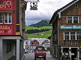
Appenzell is a village,[1][2][3] a town,[4] but not a municipality, and the capital of the canton of Appenzell Innerrhoden in Switzerland. Appenzell has no municipal government of its own; rather, the different parts of Appenzell belong to and are governed by the districts (and municipalities) Appenzell, Schwende and Rüte.[5] Because of that, for firefighting, energy and water, the village Appenzell has a special-purpose municipality, the Feuerschaugemeinde.
In 1071 the village was referred to as Abbacella. By 1223 this changed to Abbatiscella, meaning the Abbot's cell. This refers to the abbot of the Abbey of Saint Gall.
The official language of Appenzell is (the Swiss variety of Standard) German, but the main spoken language is the local variant of the Alemannic Swiss German dialect.
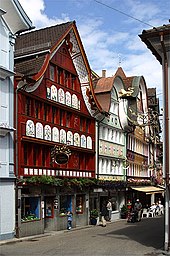


The buildings in the village core, the parish church, the 1563 town hall, the Salesis house, the ruins of Castle and the state archives with the administration building are listed as heritage sites of national significance.[3]
References[]
- ^ "Geschichtliches über das Dorf Appenzell" [Historical aspects about the village Appenzell] (official site) (in German). Appenzell, AI: District Appenzell. Retrieved 2018-08-24.
- ^ Achilles Weishaupt: Appenzell (district) in German, French and Italian in the online Historical Dictionary of Switzerland, 2011-10-06. Quote: "Das Dorf A. liegt inmitten des Talkessels der Sitter an der mittleren Ostgrenze des Bez. A. [The village A. is situated in the middle of the Sitter valley floor on the central eastern border of district A.]"
- ^ Jump up to: a b "A-Objekte" (official report). Schweizerisches Inventar der Kulturgüter von nationaler Bedeutung (in German, French, and Italian) (Ausgabe 2009). Berne, Switzerland: Bundesamt für Bevölkerungsschutz BABS. 1 April 2010. Archived from the original on 28 June 2010. Retrieved 2018-08-24.
Mittelalterliches / neuzeitliches Dorf [Medieval / contemporary village]
Cite journal requires|journal=(help) - ^ "Statistik der Schweizer Städte 2018" (PDF) (official publication). Statistisches Jahrbuch des Schweizerischen Städteverbandes (in German and French) (79.). Berne / Neuchâtel, Switzerland: Swiss Towns Association / Swiss Federal Statistical Office FSO. 17 April 2018. Retrieved 2018-08-24. Cite journal requires
|journal=(help) - ^ "Statistische Werte Bezirk Appenzell" (official site) (in German). Appenzell, AI: District Appenzell. Retrieved 2018-08-24.
Politische Aufteilung Dorf Appenzell [Political division of the village Appenzell]
External links[]
| Wikisource has the text of the 1911 Encyclopædia Britannica article Appenzell (town). |
- Appenzell Tourism
- Appenzell (in German)

| show Authority control |
|---|
- Appenzell (village)
- Cultural property of national significance in Appenzell Innerrhoden
- Cantonal capitals of Switzerland
- Cities in Switzerland