Canton of Schaffhausen
Kanton Schaffhausen | |
|---|---|
 Flag  Coat of arms | |
 Location in Switzerland
show Map of Schaffhausen | |
| Coordinates: 47°43′N 8°34′E / 47.717°N 8.567°ECoordinates: 47°43′N 8°34′E / 47.717°N 8.567°E | |
| Capital | Schaffhausen |
| Subdivisions | 26[1] municipalities |
| Government | |
| • Executive | Regierungsrat (5) |
| • Legislative | Kantonsrat (60) |
| Area | |
| • Total | 298.43 km2 (115.22 sq mi) |
| Population (December 2019)[3] | |
| • Total | 82,348 |
| • Density | 280/km2 (710/sq mi) |
| ISO 3166 code | CH-SH |
| Highest point | 912 m (2,992 ft): Hoher Randen |
| Lowest point | 344 m (1,129 ft): Rhine at Buchberg |
| Joined | 1501 |
| Languages | German |
| Website | www |
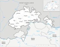

The canton of Schaffhausen, also canton of Schaffouse (German: ![]() Schaffhausen (help·info)) is the northernmost canton of Switzerland. The principal city and capital of the canton is Schaffhausen. The canton's territory is divided into three non-contiguous segments, where German territory reaches the Rhine. The large central part, which includes the capital, in turn separates the German exclave of Büsingen am Hochrhein from the rest of Germany.
Schaffhausen (help·info)) is the northernmost canton of Switzerland. The principal city and capital of the canton is Schaffhausen. The canton's territory is divided into three non-contiguous segments, where German territory reaches the Rhine. The large central part, which includes the capital, in turn separates the German exclave of Büsingen am Hochrhein from the rest of Germany.
History[]
Schaffhausen was a city-state in the Middle Ages; it is documented that it struck its own coins starting in 1045. It was then documented as Villa Scafhusun.[4] Around 1049 Count Eberhard von Nellenburg founded a Benedictine monastery which led to the development of a community. This community achieved independence in 1190. In 1330 the town lost not only all its lands but also its independence to the Habsburgs. In 1415 the Habsburg Duke Frederick IV of Austria sided with the Antipope John XXIII at the Council of Constance, and was banned by the Emperor Sigismund. As a result of the ban and Frederick's need of money, Schaffhausen was able to buy its independence from the Habsburgs in 1418. The city allied with six of the Swiss confederates in 1454 and allied with a further two (Uri and Unterwalden) in 1479. Schaffhausen became a full member of the Old Swiss Confederation in 1501.[4] The first railroad came to Schaffhausen in 1857. In 1944 Schaffhausen suffered from a bombing raid by United States Army Air Forces planes that accidentally strayed from Germany into neutral Switzerland.
The cantonal constitution was written in 1876 and revised in 1895.
The distinctive coat of arms bears the Schaffhauser Bock (billy goat of Schaffhausen).
Geography[]
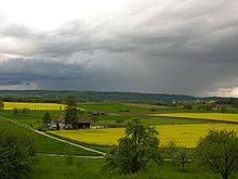
Schaffhausen is the northernmost canton of Switzerland and lies almost entirely on the right bank of the Rhine, with only part of Stein am Rhein on the left bank. It lies west of Lake Constance and has an area of 298 km2 (115 sq mi).[5] Much of the canton is productive agricultural land, with 134.4 km2 (51.9 sq mi) (about 45%) of the canton used for agriculture while an additional 128.7 km2 (49.7 sq mi) (about 43%) is wooded. Most of the rest of the canton, 31.8 km2 (12.3 sq mi) (about 10%), is developed, while only 3.8 km2 (1.5 sq mi) (1.3%) of the canton is unproductive (rivers, lakes or mountains).[6]
The canton's territory is divided into three non-contiguous segments where German territory reaches the Rhine. The large central part, which includes the capital Schaffhausen, in turn partially (along with territory of two neighbouring cantons, separates the German exclave of Büsingen am Hochrhein from the rest of Germany. The small exclave of Rüdlingen-Buchberg lies to the southwest, and the third part contains Ramsen and Stein am Rhein to the east. With the exception of Vor der Brugg, part of Stein am Rhein, all three segments are separated from the rest of Switzerland by the Rhine.
The canton of Schaffhausen is bordered by the Swiss cantons of Zurich and Thurgau, as well as the German districts of Waldshut, Schwarzwald-Baar-Kreis and Konstanz, Baden-Württemberg.
Most of the canton lies on a plateau dominated by the Hoher Randen. The summit of this mountain is at 912 m (2,992 ft). The slopes of the mountain are gentle towards the south where it reaches the Rhine valley. Short and narrow valleys intersect these gentle slopes. The Klettgau is one such valley.
The Rhine Falls are the largest waterfalls in Europe and lie on the border of the cantons of Schaffhausen and Zürich.
Municipalities[]

There are 26 municipalities in the canton as of March 2017.[7]
Changes[]
- In 1947, the municipality merged into Schaffhausen.
- In 1964, the municipality merged into Schaffhausen.
- In 2004, the municipality Barzheim merged into Thayngen.
- In 2005, the municipality Osterfingen merged into Wilchingen.
- On 1 January 2009, the municipalities Altdorf, Bibern, Hofen, and Opfertshofen merged into Thayngen.
- In 2009, the municipality Hemmental merged into Schaffhausen.
- In 2013, the municipality Guntmadingen merged into Beringen.[8]
Demographics[]
The population of the canton (as of 31 December 2019) is 82,348.[3] As of 2007, the population included 16,323 foreigners, or about 21.9% of the total population.[9] The German language and Protestant faith predominate. The majority of the population (as of 2000) is Protestant (50%) while a large minority is Roman Catholic (24%).[10]
| Year | 1850 | 1880 | 1900 | 1950 | 1970 | 2000 |
|---|---|---|---|---|---|---|
| Population | 35 300 | 38 241 | 41 514 | 57 515 | 72 854 | 73 392 |
| Language | ||||||
| German | 38 117 | 40 290 | 55 257 | 61 518 | 64 323 | |
| Italian | 39 | 886 | 1 490 | 6 682 | 1 897 | |
| French | 149 | 264 | 529 | 553 | 370 | |
| Romansch | 4 | 16 | 101 | 139 | 80 | |
| Other | 39 | 58 | 138 | 3 962 | 6 722 | |
| Religion | ||||||
| Protestant | 33 880 | 33 897 | 34 046 | 44 408 | 46 772 | 37 025 |
| Catholic | 1 411 | 4 154 | 7 403 | 12 431 | 23 277 | 17 790 |
| Chr. Catholic | 275 | 192 | 83 | |||
| Other | 9 | 297 | 65 | 401 | 2 613 | 18 494 |
| Nationality | ||||||
| Swiss | 33 938 | 33 963 | 33 860 | 53 950 | 58 907 | 58 290 |
| Other | 1 362 | 4 278 | 7 654 | 3 565 | 13 947 | 15 102 |
Politics[]
Cantonal government[]
The legislature is the Cantonal Council (Kantonsrat) of Schaffhausen, which consists of 60 members elected proportionally every four years. Until 2008, it consisted of 80 members.
The executive branch is the Government Council (Regierungsrat), which consists of 5 members elected every four years.
Federal election results[]
| Percentage of the total vote per party in the canton in the Federal Elections 1971–2015[12] | ||||||||||||||
|---|---|---|---|---|---|---|---|---|---|---|---|---|---|---|
| Party | Ideology | 1971 | 1975 | 1979 | 1983 | 1987 | 1991 | 1995 | 1999 | 2003 | 2007 | 2011 | 2015 | |
| FDP.The Liberalsa | Classical liberalism | 33.1 | 40.1 | 32.3 | 26.2 | 34.3 | 28.6 | 31.9 | 40.4 | 29.1 | 26.7 | 12.3 | 12.9 | |
| CVP/PDC/PPD/PCD | Christian democracy | 8.0 | * b | * | 6.3 | * | * | * | * | 2.7 | * | 5.2 | * | |
| SP/PS | Social democracy | 40.2 | 37.2 | 35.3 | 35.4 | 39.2 | 34.2 | 37.8 | 33.6 | 39.7 | 34.2 | 34.6 | 28.8 | |
| SVP/UDC | Swiss nationalism | * | * | 21.1 | 22.6 | 23.5 | 19.2 | 20.4 | 26.0 | 28.5 | 39.1 | 39.9 | 45.3 | |
| Ring of Independents | Social liberalism | 12.2 | 16.6 | * | 5.6 | * | * | * | * | * | * | * | * | |
| EVP/PEV | Christian democracy | * | * | 6.3 | * | * | * | * | * | * | * | * | * | |
| POCH | Progressivism | * | 6.1 | 4.1 | 2.7 | * | * | * | * | * | * | * | * | |
| GPS/PES | Green politics | * | * | * | * | * | * | * | * | * | * | * | 3.4 | |
| FGA | Feminist | * | * | * | * | * | 3.9 | * | * | * | * | * | * | |
| SD/DS | National conservatism | 6.4 | * | * | * | * | * | * | * | * | * | * | * | |
| EDU/UDF | Christian right | * | * | * | * | 3.0 | 2.7 | * | * | * | * | 3.8 | 5.1 | |
| FPS/PSL | Right-wing populism | * | * | * | * | * | 11.4 | 8.6 | * | * | * | * | * | |
| Other | * | * | 0.9 | 1.2 | * | * | 1.4 | * | * | * | 4.3 | 4.4 | ||
| Voter participation % | 78.7 | 74.1 | 75.1 | 73.7 | 69.6 | 69.0 | 64.4 | 61.9 | 63.2 | 65.3 | 60.8 | 62.6 | ||
- ^a FDP before 2009, FDP.The Liberals after 2009
- ^b "*" indicates that the party was not on the ballot in this canton.
Compulsory Voting[]
Swiss citizens who live in the canton of Schaffhausen are required to vote in elections. Compulsory voting never existed on the national level in Switzerland. It was introduced in several cantons starting in the late 19th century. In 1974, it was abolished everywhere except in Schaffhausen. Citizens who do not vote have to pay a small fine.[13]
Economy[]

Schaffhausen is a part of the Zürcher Wirtschaftsraum (Zurich economic region) and the canton's economy is well integrated with that of the wider region.
Well-regarded white Riesling wine is grown here as well as several other varieties.[14] The main industries, however, are the production of machinery and metal goods. There is also watch making and jewellery. Minor industrial branches are textiles, leather goods, glass, cement, paper and chemicals.[15] There is a brewery in the canton.
At Rheinau there is a hydro electrical power plant generating electricity for the canton and for export. Major electricity customers are the chemical industry in Rheinfelden and the aluminium plant at Neuhausen am Rheinfall. The city of Schaffhausen also uses much of the electricity produced at Rheinau.
Schaffhausen lies on the busy Milan-Zurich-Stuttgart rail line which is serviced by trains from both the Swiss Federal Railways and German Railways.[16]
The largest companies are Tyco International, Tyco Electronics, SIG, Georg Fischer AG, International Watch Company and .
Notes and references[]
- ^ "Amtliches Gemeindeverzeichnis der Schweiz – MS-Excel Version | Publikation | Bundesamt für Statistik". Bfs.admin.ch. 23 March 2017. Retrieved 16 March 2021.
- ^ Arealstatistik Land Cover - Kantone und Grossregionen nach 6 Hauptbereichen accessed 27 October 2017
- ^ Jump up to: a b "Ständige und nichtständige Wohnbevölkerung nach institutionellen Gliederungen, Geburtsort und Staatsangehörigkeit". bfs.admin.ch (in German). Swiss Federal Statistical Office - STAT-TAB. 31 December 2019. Retrieved 6 October 2020.
- ^ Jump up to: a b Chisholm, Hugh (1911). "Schaffhausen (city)". Encyclopædia Britannica. 24. p. 312. Retrieved 18 April 2009.
- ^ Canton Schaffhausen website, Geography (in German). Retrieved 18 April 2009
- ^ Federal Department of Statistics (2008). "Arealstatistik – Kantonsdaten nach 15 Nutzungsarten". Archived from the original (Microsoft Excel) on 25 July 2009. Retrieved 15 January 2009.(in German)
- ^ "Répertoire officiel des communes de Suisse". Statistique Suisse. 23 March 2017. Retrieved 28 November 2017.
- ^ Nomenklaturen – Amtliches Gemeindeverzeichnis der Schweiz (in German) accessed 28 November 2017
- ^ Federal Department of Statistics (2008). "Ständige Wohnbevölkerung nach Staatsangehörigkeit, Geschlecht und Kantonen". Archived from the original (Microsoft Excel) on 15 December 2008. Retrieved 5 November 2008.
- ^ Federal Department of Statistics (2004). "Wohnbevölkerung nach Religion". Archived from the original (Interactive Map) on 24 September 2016. Retrieved 15 January 2009.
- ^ "Schaffhausen (Kanton)". hls-dhs-dss.ch.
- ^ Nationalratswahlen: Stärke der Parteien nach Kantonen (Schweiz = 100%) (Report). Swiss Federal Statistical Office. 2015. Archived from the original on 2 August 2016. Retrieved 5 August 2016.
- ^ Leybold-Johnson, Isobel (4 April 2014). "Democratic? The canton where voting is compulsory". swissinfo.ch. Retrieved 15 October 2020.
- ^ Canton Schaffhausen website, Wine Production (in German). Retrieved 18 April 2009
- ^ Canton Schaffhausen website- Economic Promotion Archived 17 July 2010 at the Wayback Machine. Retrieved 18 April 2009
- ^ "Economic Promotion: Canton Schaffhausen: Geographic Location". Canton Schaffhausen. Archived from the original on 23 September 2009. Retrieved 6 January 2015.
External links[]
| Wikimedia Commons has media related to Canton of Schaffhausen. |
- Official site (in German)
- Archives (in German)
- Official statistics
- Digitized Edition of Chronik der Stadt und Landschaft Schaffhausen, in German, 1884–1910, at E-rara

| show Authority control |
|---|
- Canton of Schaffhausen
- Cantons of Switzerland
- Cantons of the Helvetic Republic
- 15th-century establishments in the Old Swiss Confederacy
- 1450s establishments in the Holy Roman Empire
- 1454 establishments in Europe