Gächlingen
Gächlingen | |
|---|---|
 | |
 Coat of arms | |
show Location of Gächlingen | |
 Gächlingen | |
| Coordinates: 47°42′N 8°30′E / 47.700°N 8.500°ECoordinates: 47°42′N 8°30′E / 47.700°N 8.500°E | |
| Country | Switzerland |
| Canton | Schaffhausen |
| District | n.a. |
| Area | |
| • Total | 7.13 km2 (2.75 sq mi) |
| Elevation | 460 m (1,510 ft) |
| Population (2018-12-31)[2] | |
| • Total | 836 |
| • Density | 120/km2 (300/sq mi) |
| Time zone | UTC+01:00 (Central European Time) |
| • Summer (DST) | UTC+02:00 (Central European Summer Time) |
| Postal code(s) | 8214 |
| SFOS number | 2901 |
| Surrounded by | Neunkirch, Oberhallau, Schleitheim, Siblingen |
| Website | www Profile (in German), SFSO statistics |


Gächlingen is a municipality in the canton of Schaffhausen in Switzerland.
History[]

An area near Gächlingen was the site of the first settlement in Switzerland. This Linear Band Ceramic settlement dates to about 6000BC and is the first long-term, farming community in the borders of modern Switzerland.[3] Gächlingen is first mentioned in a 10th Century forgery as Câhtelinga. In 1049 it was mentioned as Gehtelinga.[4]
Geography[]
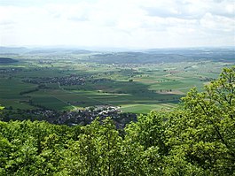
Gächlingen has an area, as of 2006, of 7.3 km2 (2.8 sq mi). Of this area, 75.1% is used for agricultural purposes, while 17.6% is forested. Of the rest of the land, 7% is settled (buildings or roads) and the remainder (0.3%) is non-productive (rivers or lakes).[5]
The municipality is located in the Oberklettgau district. It is a wine producing village on the south flank of the Randen mountain.
Heritage sites of national significance[]
The Goldäcker, a Neolithic settlement is listed as a Swiss heritage site of national significance.[6] While the region that would become Switzerland had been occupied by nomadic hunter-gatherers the settlement at Goldäcker is the first long-term, farming settlement in Switzerland. About 6000 BC, a group of Linear Band Ceramic Culture farmers moved south over the Danube river. They settled in a small hamlet on the western border of modern Gächlingen. Their settlement included both houses and manufacturing buildings.[3]
Additionally, the entire village of Gächlingen is designated as part of the Inventory of Swiss Heritage Sites.[7]
Coat of arms[]
The blazon of the municipal coat of arms is Gules a Sickle Argent ringed Or handled proper and a Ploughshare of the second.[8]
Demographics[]
Gächlingen has a population (as of 2008) of 764, of which 5.5% are foreign nationals. Of the foreign population, (as of 2008), 36.4% are from Germany, 6.8% are from Italy, 13.6% are from Macedonia, and 43.2% are from another country.[9] Over the last 10 years the population has decreased at a rate of -5.5%. Most of the population (as of 2000) speaks German (96.1%), with Albanian being second most common ( 1.0%) and Italian being third ( 0.7%).[5]
The age distribution of the population (as of 2008) is children and teenagers (0–19 years old) make up 18.8% of the population, while adults (20–64 years old) make up 61.5% and seniors (over 64 years old) make up 19.6%.[9]
In the 2007 federal election the most popular party was the SVP which received 47.4% of the vote. The next two most popular parties were the SP (29.6%), and the FDP (23.1%) .[5]
In Gächlingen about 74.6% of the population (between age 25-64) have completed either non-mandatory upper secondary education or additional higher education (either university or a Fachhochschule).[5] In Gächlingen, as of 2007, 0.77% of the population attend kindergarten or another pre-school, 7.35% attend a Primary School, 2.96% attend a lower level Secondary School, and 4.77% attend a higher level Secondary School.[9]
As of 2000, 11.5% of the population belonged to the Roman Catholic Church and 74.3% belonged to the Swiss Reformed Church.[9]
The historical population is given in the following table:[4]
| year | population |
|---|---|
| 1531 | 24 Households |
| 1801 | 705 |
| 1850 | 1,194 |
| 1900 | 794 |
| 1950 | 682 |
| 1970 | 604 |
| 2000 | 872 |
Economy[]
Gächlingen has an unemployment rate of 1.03%. As of 2005, there were 84 people employed in the primary economic sector and about 30 businesses involved in this sector. 46 people are employed in the secondary sector and there are 10 businesses in this sector. 48 people are employed in the tertiary sector, with 18 businesses in this sector.[5]
As of 2008 the mid year average unemployment rate was 0.5%. There were 35 non-agrarian businesses in the municipality and 49.5% of the (non-agrarian) population was involved in the secondary sector of the economy while 50.5% were involved in the third. At the same time, 67.3% of the working population was employed full-time, and 32.7% was employed part-time. There were 101 residents of the municipality who were employed in some capacity, of which females made up 30.7% of the workforce. As of 2000 there were 129 residents who worked in the municipality, while 277 residents worked outside Gächlingen and 93 people commuted into the municipality for work.[9]
As of 2008, there is 1 restaurant and the hospitality industry in Gächlingen employs 1 people.[9]
References[]
- ^ Jump up to: a b "Arealstatistik Standard - Gemeinden nach 4 Hauptbereichen". Federal Statistical Office. Retrieved 13 January 2019.
- ^ "Ständige Wohnbevölkerung nach Staatsangehörigkeitskategorie Geschlecht und Gemeinde; Provisorische Jahresergebnisse; 2018". Federal Statistical Office. 9 April 2019. Retrieved 11 April 2019.
- ^ Jump up to: a b City of Gächlingen Archived 6 July 2011 at the Wayback Machine (in German) accessed 9 December 2009
- ^ Jump up to: a b Gächlingen in German, French and Italian in the online Historical Dictionary of Switzerland.
- ^ Jump up to: a b c d e Swiss Federal Statistical Office accessed 9 December 2009
- ^ Swiss inventory of cultural property of national and regional significance Archived 1 May 2009 at the Wayback Machine 21.11.2008 version, (in German) accessed 09-Dec-2009
- ^ ISOS site accessed 8 December 2009
- ^ Flags of the World.com Archived 5 June 2011 at the Wayback Machine accessed 9 December 2009
- ^ Jump up to: a b c d e f Statistical Office of the Canton of Schaffhausen (in German) accessed 2 December 2009
| Wikimedia Commons has media related to Gächlingen. |
External links[]
- Gächlingen in German, French and Italian in the online Historical Dictionary of Switzerland.
| show Authority control |
|---|
- Municipalities of the canton of Schaffhausen
- Cultural property of national significance in the canton of Schaffhausen