Sainte-Aurélie, Quebec
Sainte-Aurélie | |
|---|---|
Municipality | |
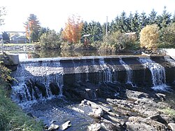 Dam over Abenaquis Lake. | |
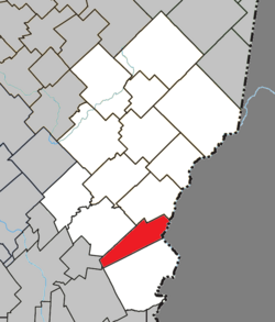 Location within Les Etchemins RCM. | |
 Sainte-Aurélie Location in southern Quebec. | |
| Coordinates: 46°11′N 70°22′W / 46.183°N 70.367°WCoordinates: 46°11′N 70°22′W / 46.183°N 70.367°W[1] | |
| Country | |
| Province | |
| Region | Chaudière-Appalaches |
| RCM | Les Etchemins |
| Constituted | April 3, 1909 |
| Government | |
| • Mayor | Gilles Gaudet |
| • Federal riding | Beauce |
| • Prov. riding | Beauce-Sud |
| Area | |
| • Total | 79.90 km2 (30.85 sq mi) |
| • Land | 77.81 km2 (30.04 sq mi) |
| Population (2011)[3] | |
| • Total | 910 |
| • Density | 11.7/km2 (30/sq mi) |
| • Pop 2006-2011 | |
| • Dwellings | 534 |
| Time zone | UTC−5 (EST) |
| • Summer (DST) | UTC−4 (EDT) |
| Postal code(s) | G0M 1M0 |
| Area code(s) | 418 and 581 |
| Highways | |
| Website | www |

Sainte-Aurélie is a municipality in the Les Etchemins Regional County Municipality in the Chaudière-Appalaches region of Quebec, Canada. Its population is 910 as of the Canada 2011 Census. It is named after Sister Sainte-Aurélie, an Ursuline nun at the end of the 19th century.
Sainte-Aurélie has a small border crossing to the United States of America, Ste. Aurelie Station.
Sainte-Aurélie was founded by a Frenchman named Victor Vanier in 1906.
References[]
- ^ Reference number 56059 of the Commission de toponymie du Québec (in French)
- ^ Jump up to: a b Geographic code 28015 in the official Répertoire des municipalités (in French)
- ^ Jump up to: a b "(Code 2428015) Census Profile". 2011 census. Statistics Canada. 2012.
- Commission de toponymie du Québec
- Ministère des Affaires municipales, des Régions et de l'Occupation du territoire
- Canada Border Services Agency
| show Places adjacent to Sainte-Aurélie, Quebec |
|---|
| show |
|---|
| Authority control |
|
|---|
Categories:
- Incorporated places in Chaudière-Appalaches
- Municipalities in Quebec