Sakurayama
| Sakurayama | |
|---|---|
 Sakurayama in spring | |
| Highest point | |
| Elevation | 591 m (1,939 ft) |
| Coordinates | 36°09′42.1″N 139°01′16.2″E / 36.161694°N 139.021167°E |
| Naming | |
| Native name | 桜山 |
| Geography | |
 Sakurayama Sakurayama | |
| Country | Japan |
| State | Gunma Prefecture |
| Region | Kantō region |
| Climbing | |
| Easiest route | Hiking |


Sakurayama (桜山) is a mountain in the city of Fujioka, Gunma Prefecture, Japan. It is 591 metres (1,939 ft) in height, and was named one of the "100 Sakura Spots in Japan" during Expo '90 by the International Flower and Green Expo Association. It is also a National Place of Scenic Beauty as determined by the Agency for Cultural Affairs in Japan.[1]
Overview[]
In premodern times, the mountain was called "Kokuzōsan" and was a center for the Shugendō mountain cults for the worship of Kokūzō Bosatsu. In 1908, the mountain was planted with thousands of Somei Yoshino cherry trees in commemoration of Japan's victory in the Russo-Japanese War. These trees have evolved or mutated, so that the bloom much earlier than in other locations and the flowers last longer. The mountain was designated as a National Place of Scenic Beauty in 1937. The trees on the mountain were designated a Living National Monument in 1948. The mountain became part of the Gunma Prefectural Sakurayama Forest Park in 1989.
The mountain is located on the middle reaches of the Sanba River (三波川) and can be reached in about 35 minutes by car from Fujioka Interchange of yer Joshin'etsu Expressway.
Gallery[]
Sakurayama in spring

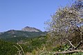
Sakurayama in summer
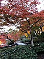
Sakurayama Park in autumn

Sakurayama in winter
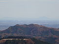
Panorama from summit of Sakurayama with Mount Ontake


See also[]
References[]
- ^ "三波川(サクラ)". Agency for Cultural Affairs. Retrieved 10 July 2020.
External links[]
| Wikimedia Commons has media related to Sakurayama. |
- Mountains of Gunma Prefecture
- Fujioka, Gunma
- Places of Scenic Beauty
- Hanami spots of Japan