Salangselva
| Salangselva Salangsdalselva | |
|---|---|
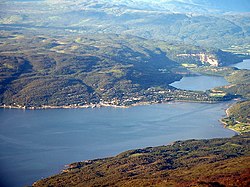 Sjøvegan and the outlet of Salangselva into Sagfjorden | |
 Location of the river | |
| Location | |
| Country | Norway |
| County | Troms og Finnmark |
| Municipalities | Bardu Municipality, Salangen Municipality |
| Physical characteristics | |
| Source | Isvatnet |
| • location | Salangsdalen, Bardu |
| • coordinates | 68°33′08″N 18°09′25″E / 68.5521°N 18.15688°E |
| • elevation | 801 metres (2,628 ft) |
| Mouth | Salangen fjord |
• location | Sjøvegan, Salangen |
• coordinates | 68°51′57″N 17°51′28″E / 68.8657°N 17.8577°ECoordinates: 68°51′57″N 17°51′28″E / 68.8657°N 17.8577°E |
• elevation | 0 metres (0 ft) |
| Length | 53 km (33 mi) |
| Basin size | 580 km2 (220 sq mi) |


Salangselva is a river in Troms og Finnmark county, Norway. The 53-kilometre (33 mi) long river runs through the municipalities of Salangen and Bardu. The river originates from the lake Isvatnet, flows through the Salangsdalen valley, the waterfall and the lake Øvrevatnet, and empties into the Sagfjorden at the village of Sjøvegan.[1][2]
References[]
- ^ Evensen, Knut Harald, ed. (2010). NAF Veibok 2010–2012 (in Norwegian) (29 ed.). Oslo: Norges Automobil-Forbund. pp. 114, 502.
- ^ Thorsnæs, Geir, ed. (2018-04-09). "Salangselva". Store norske leksikon (in Norwegian). Kunnskapsforlaget. Retrieved 2018-08-19.
This article about a location in Troms og Finnmark is a stub. You can help Wikipedia by . |
Categories:
- Rivers of Troms og Finnmark
- Salangen
- Bardu
- Rivers of Norway
- Troms og Finnmark geography stubs
- Norway river stubs