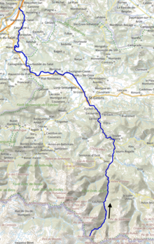
Salat (river)
| Salat | |
|---|---|
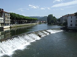 In Saint-Girons | |
 | |
| Location | |
| Country | France |
| Physical characteristics | |
| Source | |
| • location | Mont Rouch, Pyrenees |
| • elevation | 2,500 m (8,200 ft) |
| Mouth | |
• location | Garonne |
• coordinates | 43°9′40″N 0°57′58″E / 43.16111°N 0.96611°ECoordinates: 43°9′40″N 0°57′58″E / 43.16111°N 0.96611°E |
| Length | 74 km (46 mi) |
| Basin size | 1,570 km2 (610 sq mi) |
| Discharge | |
| • average | 43 m3/s (1,500 cu ft/s) |
| Basin features | |
| Progression | Garonne→ Gironde estuary→ Atlantic Ocean |

The Salat (French pronunciation: [sala]; Occitan: Salat) is a river in southern France, a right tributary of the Garonne. It is 74.1 km (46.0 mi) long.[1] It rises in nine points above the hamlet Salau in the municipality Couflens, on the slopes of , central Pyrenees. The former Gascon province of Couserans is based on its valley.
Departments and Cities[]
Main tributaries[]
References[]
External links[]
| Wikimedia Commons has media related to Salat River. |
| hide Authority control | |
|---|---|
| General |
|
| National libraries | |
Categories:
- Tributaries of the Garonne
- Rivers of France
- Rivers of Ariège (department)
- Rivers of Haute-Garonne
- Rivers of Occitanie
- France river stubs