San Juan, Ilocos Sur
San Juan
Lapog | |
|---|---|
| Municipality of San Juan | |
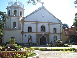 St. John the Baptist Catholic Church | |
 Seal | |
| Nickname(s): Buri Capital of the Philippines | |
 Map of Ilocos Sur with San Juan highlighted | |
OpenStreetMap  | |
 San Juan Location within the Philippines | |
| Coordinates: 17°44′32″N 120°27′30″E / 17.74222°N 120.45833°ECoordinates: 17°44′32″N 120°27′30″E / 17.74222°N 120.45833°E | |
| Country | Philippines |
| Region | Ilocos Region |
| Province | Ilocos Sur |
| District | 1st district |
| Named for | St. John the Baptist |
| Barangays | 32 (see Barangays) |
| Government | |
| • Type | Sangguniang Bayan |
| • Mayor | Ma. Elaine A. Sarmiento |
| • Vice Mayor | Benjamin V. Sarmiento |
| • Representative | Deogracias Victor B. Savellano |
| • Municipal Council | Members |
| • Electorate | 18,038 voters (2019) |
| Area | |
| • Total | 64.37 km2 (24.85 sq mi) |
| Elevation | 41 m (135 ft) |
| Highest elevation | 307 m (1,007 ft) |
| Lowest elevation | 0 m (0 ft) |
| Population (2020 census) [3] | |
| • Total | 26,674 |
| • Density | 410/km2 (1,100/sq mi) |
| • Households | 6,151 |
| Economy | |
| • Income class | 3rd municipal income class |
| • Poverty incidence | 11.68% (2015)[4] |
| • Revenue | ₱244,338,511.72 (2020) |
| • Assets | ₱1,276,612,321.04 (2020) |
| • Expenditure | ₱242,960,257.40 (2020) |
| • Liabilities | ₱123,384,126.33 (2020) |
| Service provider | |
| • Electricity | Ilocos Sur Electric Cooperative (ISECO) |
| Time zone | UTC+8 (PST) |
| ZIP code | 2731 |
| PSGC | |
| IDD : area code | +63 (0)77 |
| Native languages | Ilocano Tagalog |

San Juan, officially the Municipality of San Juan (Ilocano: Ili ti San Juan; Filipino: Bayan ng San Juan), formerly called as Lapog, is a 3rd class municipality in the province of Ilocos Sur, Philippines. According to the 2020 census, it has a population of 26,674 people. [3]
Because it produces most of the goods made of buri leaf in the province, it is sometimes called the Buri Capital of Ilocos Sur.
History[]
The town of Lapog was established in 1772.
The name of the municipality has gone through a series of changes. The early settlers and occupants called it "Lapo", short for "Lapo-Lapo", a tall grass which grew everywhere in the area. In the year 1772, Don Tomas Aquino, the first local leader, initiated the organization of the scattered communities into one, calling the place "Lapog", a derivative of local vernacular "Lap-Lapog" which means unirrigated land. For 189 years, "Lapog" remained in the records as the official name of the town until June 18, 1961, Republic Act No. 3386 was enacted and it was renamed to San Juan. Since most of the inhabitants were of the belief that religious names bring peace, happiness, and prosperity, the town was renamed "San Juan", after the name of its patron saint, Saint John the Baptist.
It was stricken by all sorts of plagues and epidemics (like the smallpox epidemics of 1808 and 1918–19, locust infestation in 1903, and destruction of ricefields by worms called "arabas" in 1905). Bessang Pass, just south of the poblacion, was constructed in 1874. Americans destroyed their town hall in 1903. But despite these misfortunes, San Juan progressed into a prosperous community.
Geography[]
San Juan is 426 kilometres (265 mi) from Metro Manila and 21 kilometres (13 mi) from Vigan City, the provincial capital.
Barangays[]
San Juan is politically subdivided into 32 barangays. [5]
- Asilang
- Bacsil
- Baliw
- Bannuar (Poblacion)
- Barbar
- Cabanglotan
- Cacandongan
- Camanggaan
- Camindoroan
- Caronoan
- Darao
- Dardarat
- Guimod Norte
- Guimod Sur
- Immayos Norte
- Immayos Sur
- Labnig
- Lapting
- Lira (Poblacion)
- Malamin
- Muraya
- Nagsabaran
- Nagsupotan
- Pandayan (Poblacion)
- Refaro
- Resurreccion (Poblacion)
- Sabangan
- San Isidro
- Saoang
- Solotsolot
- Sunggiam
- Surngit
Climate[]
| Climate data for San Juan, Ilocos Sur | |||||||||||||
|---|---|---|---|---|---|---|---|---|---|---|---|---|---|
| Month | Jan | Feb | Mar | Apr | May | Jun | Jul | Aug | Sep | Oct | Nov | Dec | Year |
| Average high °C (°F) | 30 (86) |
31 (88) |
32 (90) |
34 (93) |
33 (91) |
31 (88) |
30 (86) |
30 (86) |
30 (86) |
31 (88) |
30 (86) |
29 (84) |
31 (88) |
| Average low °C (°F) | 18 (64) |
19 (66) |
21 (70) |
23 (73) |
24 (75) |
25 (77) |
24 (75) |
24 (75) |
24 (75) |
22 (72) |
21 (70) |
19 (66) |
22 (72) |
| Average precipitation mm (inches) | 9 (0.4) |
11 (0.4) |
13 (0.5) |
23 (0.9) |
92 (3.6) |
122 (4.8) |
153 (6.0) |
137 (5.4) |
139 (5.5) |
141 (5.6) |
42 (1.7) |
14 (0.6) |
896 (35.4) |
| Average rainy days | 4.6 | 4.0 | 6.2 | 9.1 | 19.5 | 23.2 | 24.0 | 22.5 | 21.5 | 15.2 | 10.5 | 6.0 | 166.3 |
| Source: Meteoblue (modeled/calculated data, not measured locally) [6] | |||||||||||||
Demographics[]
| Year | Pop. | ±% p.a. |
|---|---|---|
| 1903 | 7,035 | — |
| 1918 | 9,791 | +2.23% |
| 1939 | 10,674 | +0.41% |
| 1948 | 9,777 | −0.97% |
| 1960 | 12,654 | +2.17% |
| 1970 | 14,987 | +1.70% |
| 1975 | 16,329 | +1.73% |
| 1980 | 17,443 | +1.33% |
| 1990 | 20,328 | +1.54% |
| 1995 | 21,222 | +0.81% |
| 2000 | 23,146 | +1.88% |
| 2007 | 23,808 | +0.39% |
| 2010 | 25,199 | +2.09% |
| 2015 | 26,411 | +0.90% |
| 2020 | 26,674 | +0.20% |
| Source: Philippine Statistics Authority [7] [8] [9][10] | ||
In the 2020 census, San Juan had a population of 26,674. [3] The population density was 410 inhabitants per square kilometre (1,100/sq mi).
Economy[]
| Poverty Incidence of San Juan | |
| Source: Philippine Statistics Authority[11][12][13][14][15][16] | |
See also[]
References[]
- ^ Municipality of San Juan | (DILG)
- ^ "2015 Census of Population, Report No. 3 – Population, Land Area, and Population Density" (PDF). Philippine Statistics Authority. Quezon City, Philippines. August 2016. ISSN 0117-1453. Archived (PDF) from the original on May 25, 2021. Retrieved July 16, 2021.
- ^ a b c Census of Population (2020). "Region I (Ilocos Region)". Total Population by Province, City, Municipality and Barangay. PSA. Retrieved 8 July 2021.
- ^ https://psa.gov.ph/sites/default/files/City%20and%20Municipal-level%20Small%20Area%20Poverty%20Estimates_%202009%2C%202012%20and%202015_0.xlsx; publication date: 10 July 2019; publisher: Philippine Statistics Authority.
- ^ "Province: Ilocos Sur". PSGC Interactive. Quezon City, Philippines: Philippine Statistics Authority. Retrieved 12 November 2016.
- ^ "San Juan: Average Temperatures and Rainfall". Meteoblue. Retrieved 14 May 2020.
- ^ Census of Population (2015). "Region I (Ilocos Region)". Total Population by Province, City, Municipality and Barangay. PSA. Retrieved 20 June 2016.
- ^ Census of Population and Housing (2010). "Region I (Ilocos Region)". Total Population by Province, City, Municipality and Barangay. NSO. Retrieved 29 June 2016.
- ^ Censuses of Population (1903–2007). "Region I (Ilocos Region)". Table 1. Population Enumerated in Various Censuses by Province/Highly Urbanized City: 1903 to 2007. NSO.
- ^ "Province of Ilocos Sur". Municipality Population Data. Local Water Utilities Administration Research Division. Retrieved 17 December 2016.
- ^ "Poverty incidence (PI):". Philippine Statistics Authority. Retrieved 28 December 2020.
- ^ https://psa.gov.ph/sites/default/files/NSCB_LocalPovertyPhilippines_0.pdf; publication date: 29 November 2005; publisher: Philippine Statistics Authority.
- ^ https://psa.gov.ph/sites/default/files/2003%20SAE%20of%20poverty%20%28Full%20Report%29_1.pdf; publication date: 23 March 2009; publisher: Philippine Statistics Authority.
- ^ https://psa.gov.ph/sites/default/files/2006%20and%202009%20City%20and%20Municipal%20Level%20Poverty%20Estimates_0_1.pdf; publication date: 3 August 2012; publisher: Philippine Statistics Authority.
- ^ https://psa.gov.ph/sites/default/files/2012%20Municipal%20and%20City%20Level%20Poverty%20Estima7tes%20Publication%20%281%29.pdf; publication date: 31 May 2016; publisher: Philippine Statistics Authority.
- ^ https://psa.gov.ph/sites/default/files/City%20and%20Municipal-level%20Small%20Area%20Poverty%20Estimates_%202009%2C%202012%20and%202015_0.xlsx; publication date: 10 July 2019; publisher: Philippine Statistics Authority.
External links[]
- Act renaming the Municipality of Lapog to San Juan
- Pasyalang Ilocos Sur
- Lapog ... our town, our home
- Lapoguenio Perspectives
- Philippine Standard Geographic Code
- Philippine Census Information
- Local Governance Performance Management System
Places adjacent to San Juan, Ilocos Sur | ||||||||||||||||
|---|---|---|---|---|---|---|---|---|---|---|---|---|---|---|---|---|
| ||||||||||||||||
- Municipalities of Ilocos Sur