San Juan Chamelco
San Juan Chamelco | |
|---|---|
Municipality | |
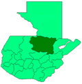
 San Juan Chamelco Location in Guatemala | |
| Coordinates: 15°25′32.430″N 90°19′34.626″W / 15.42567500°N 90.32628500°WCoordinates: 15°25′32.430″N 90°19′34.626″W / 15.42567500°N 90.32628500°W | |
| Country | |
| Department | |
| Municipality | San Juan Chamelco |
| Government | |
| • Type | Municipal |
| Area | |
| • Total | 228 km2 (88 sq mi) |
| Population (2018 census)[1] | |
| • Total | 57,456 |
| • Density | 250/km2 (650/sq mi) |
| • Ethnicities | Q'eqchi' Ladino |
| • Religions | Roman Catholicism Evangelicalism Maya |
| Climate | Cfb |

San Juan Chamelco is a town, with a population of 13,264 (2018 census),[2] and a municipality in the Guatemalan department of Alta Verapaz. The municipality is situated at 1350 metres above sea level and covers an area of 228 km². The annual festival is on June 24.
Climate[]
San Juan Chamelco has temperate climate (Köppen: Cfb).
| hideClimate data for San Juan Chamelco | |||||||||||||
|---|---|---|---|---|---|---|---|---|---|---|---|---|---|
| Month | Jan | Feb | Mar | Apr | May | Jun | Jul | Aug | Sep | Oct | Nov | Dec | Year |
| Average high °C (°F) | 20.8 (69.4) |
22.4 (72.3) |
23.8 (74.8) |
24.4 (75.9) |
24.6 (76.3) |
23.9 (75.0) |
23.1 (73.6) |
23.6 (74.5) |
23.6 (74.5) |
22.7 (72.9) |
21.7 (71.1) |
21.2 (70.2) |
23.0 (73.4) |
| Daily mean °C (°F) | 15.5 (59.9) |
16.6 (61.9) |
17.8 (64.0) |
18.8 (65.8) |
19.6 (67.3) |
19.7 (67.5) |
19.1 (66.4) |
19.2 (66.6) |
19.2 (66.6) |
18.4 (65.1) |
17.2 (63.0) |
16.4 (61.5) |
18.1 (64.6) |
| Average low °C (°F) | 10.3 (50.5) |
10.9 (51.6) |
11.9 (53.4) |
13.3 (55.9) |
14.6 (58.3) |
15.5 (59.9) |
15.2 (59.4) |
14.9 (58.8) |
14.9 (58.8) |
14.1 (57.4) |
12.8 (55.0) |
11.6 (52.9) |
13.3 (56.0) |
| Average precipitation mm (inches) | 105 (4.1) |
72 (2.8) |
91 (3.6) |
83 (3.3) |
158 (6.2) |
286 (11.3) |
254 (10.0) |
240 (9.4) |
300 (11.8) |
283 (11.1) |
193 (7.6) |
116 (4.6) |
2,181 (85.8) |
| Source: Climate-Data.org[3] | |||||||||||||
Geographic location[]
San Juan Chamelco is surrounded by Alta Verapaz Department municipalities.[4]
| show Places adjacent to San Juan Chamelco |
|---|
See also[]
- Fernando Romeo Lucas Garcia
References[]
- ^ Citypopulation.de Population of departments and municipalities in Guatemala
- ^ Citypopulation.de Population of cities & towns in Guatemala
- ^ "Climate: San Juan Chamelco". Climate-Data.org. Retrieved 21 August 2015.
- ^ Jump up to: a b c SEGEPLAN. "Municipios de Alta Verapaz, Guatemala". Secretaría General de Planificación y Programación de la Presidencia de la República (in Spanish). Guatemala. Archived from the original on 30 June 2015. Retrieved 30 June 2015.
External links[]
| show Authority control |
|---|
Categories:
- Municipalities of the Alta Verapaz Department