Tucurú
Tucurú
San Miguel Tucurú | |
|---|---|
Municipality | |
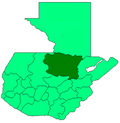
 Tucurú Location in Alta Verapaz | |
| Coordinates: 15°18′0″N 90°04′0″W / 15.30000°N 90.06667°WCoordinates: 15°18′0″N 90°04′0″W / 15.30000°N 90.06667°W | |
| Country | |
| Department | |
| Government | |
| • Mayor | René Alfredo Tun[1] (PP) |
| Area | |
| • Municipality | 219 km2 (85 sq mi) |
| Elevation | 477 m (1,565 ft) |
| Population (2018 census)[2] | |
| • Municipality | 43,473 |
| • Density | 200/km2 (510/sq mi) |
| • Urban | 4,064 |
| Time zone | GMT -6 |
| Climate | Af |


Tucurú is a small town and municipality in the Guatemalan department of Alta Verapaz.
History[]
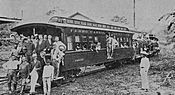
Verapaz Railroad[]

The Verapaz Railroad began on 15 January 1894 with a contract for 99 years between Guatemala, then ruled by president José María Reina Barrios and Walter Dauch, representative of the "Verapaz Railroad & Northern Agency Ltd." The contract settled the rules for the construction and maintenance of a 30 mile railroad line between Panzós and Pancajché. Passenger service travelled twice a week, on Mondays and Thursdays; mail also arrived by ship every Wednesday and cargo came from Livingston, Izabal. Besides, there were train stops in Santa Rosita, Santa Catalina La Tinta, and Papalhá.[3]
In 1898, it was reported that given the coffee prosperity in Cobán, which in those days was the third largest city in Guatemala, the railroad was going to be extended to that city.[3] The railroad was in operation until 1965, when it was superseded by truck and highways.


Thomae family[]
One of the most powerful German families that settled in the region by the end of the 19th century was the Thomae family, who had their headquarters in neighbor Purulhá. Mauricio Thomae's early farmland had the following haciendas:[5]
| Year | Hacienda | hideLocation |
|---|---|---|
| 1882 | Cubilgüitz | Cobán |
| 1889 | San Isidro | Purulhá |
| 1897 | Comija | Tamahú |
| 1897 | Popabaj | Tucurú |
| 1900 | Nueve Aguas | Purulhá |
| 1902 | Panzal | Purulhá |
| 1902 | Rocjá | Tamahú |
| 1902 | Paijá | Tucurú |
| 1905 | Chimox | Tucurú[5] |
Years later, during general Jorge Ubico's presidency (1931-1944), Thomae went on to become one of the most influential landlords in the German Verapaz, along with the Sarg, Sapper and Diesseldorf families. Ubico had been governor of Cobán during Manuel Estrada Cabrera 22-year regime and befriended several German families, including the Thomaes.[5]
Climate[]
Tucurú has a tropical rainforest climate (Köppen: Af).
| hideClimate data for Tucurú | |||||||||||||
|---|---|---|---|---|---|---|---|---|---|---|---|---|---|
| Month | Jan | Feb | Mar | Apr | May | Jun | Jul | Aug | Sep | Oct | Nov | Dec | Year |
| Average high °C (°F) | 27.8 (82.0) |
29.7 (85.5) |
30.9 (87.6) |
32.4 (90.3) |
32.0 (89.6) |
31.1 (88.0) |
30.1 (86.2) |
30.7 (87.3) |
30.6 (87.1) |
29.6 (85.3) |
28.5 (83.3) |
27.9 (82.2) |
30.1 (86.2) |
| Daily mean °C (°F) | 22.6 (72.7) |
23.8 (74.8) |
25.0 (77.0) |
26.4 (79.5) |
26.5 (79.7) |
26.1 (79.0) |
25.5 (77.9) |
25.8 (78.4) |
25.8 (78.4) |
25.0 (77.0) |
23.8 (74.8) |
23.0 (73.4) |
24.9 (76.9) |
| Average low °C (°F) | 17.5 (63.5) |
18.0 (64.4) |
19.2 (66.6) |
20.5 (68.9) |
21.0 (69.8) |
21.1 (70.0) |
21.0 (69.8) |
20.9 (69.6) |
21.0 (69.8) |
20.4 (68.7) |
19.1 (66.4) |
18.2 (64.8) |
19.8 (67.7) |
| Average precipitation mm (inches) | 88 (3.5) |
62 (2.4) |
64 (2.5) |
96 (3.8) |
185 (7.3) |
373 (14.7) |
397 (15.6) |
307 (12.1) |
385 (15.2) |
394 (15.5) |
159 (6.3) |
92 (3.6) |
2,602 (102.5) |
| Source: Climate-Data.org[6] | |||||||||||||
Geographic location[]
| show Places adjacent to Tucurú |
|---|
See also[]
Notes and references[]
References[]
- ^ "Elecciones de Guatemala de 2011" (PDF). Prensa Libre. Guatemala. 2011. Archived from the original (PDF) on 26 November 2011. Retrieved 29 June 2015.
- ^ Citypopulation.de Population of departments and municipalities in Guatemala
- ^ Jump up to: a b La Ilustración del Pacífico & 15 March 1898, p. 206
- ^ Jump up to: a b La Ilustración del Pacífico & 15 March 1898, pp. 203–204
- ^ Jump up to: a b c "Nepotismo y la decadencia de la familia Thomae". Centro de Medios Independiente de Guatemala (in Spanish). Guatemala. 20 July 2015. Archived from the original on 8 August 2015. Retrieved 7 August 2015.
- ^ "Climate: Tucurú". Climate-Data.org. Retrieved 26 August 2015.
- ^ Jump up to: a b Segeplan. "Municipios de Alta Verapaz, Guatemala". Secretaría General de Planificación y Programación de la Presidencia de la República (in Spanish). Guatemala. Archived from the original on 30 June 2015. Retrieved 30 June 2015.
Bibliography[]
- La Ilustración del Pacífico (15 March 1898). "La revolución de septiembre". La Ilustración del Pacífico (in Spanish). Guatemala: Siguere, Guirola y Cía. II (38).
External links[]
- Municipalities of the Alta Verapaz Department