San Remigio, Antique
San Remigio | |
|---|---|
| Municipality of San Remigio | |
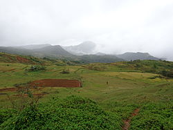 San Remigio landscape | |
 Map of Antique with San Remigio highlighted | |
show OpenStreetMap | |
 San Remigio Location within the Philippines | |
| Coordinates: 10°49′59″N 122°05′15″E / 10.833092°N 122.087506°ECoordinates: 10°49′59″N 122°05′15″E / 10.833092°N 122.087506°E | |
| Country | Philippines |
| Region | Western Visayas |
| Province | Antique |
| District | Lone district |
| Founded | July 1, 1864 |
| Named for | Saint Remigius |
| Barangays | 45 (see Barangays) |
| Government | |
| • Type | Sangguniang Bayan |
| • Mayor | Margarito C. Mission Jr. |
| • Vice Mayor | Graham V. Cabigunda |
| • Representative | Loren Legarda |
| • Electorate | 20,657 voters (2019) |
| Area | |
| • Total | 406.98 km2 (157.14 sq mi) |
| Elevation | 407 m (1,335 ft) |
| Highest elevation | 1,584 m (5,197 ft) |
| Lowest elevation | 0 m (0 ft) |
| Population (2020 census) [3] | |
| • Total | 34,045 |
| • Density | 84/km2 (220/sq mi) |
| • Households | 6,579 |
| Economy | |
| • Income class | 3rd municipal income class |
| • Poverty incidence | 35.26% (2015)[4] |
| • Revenue | ₱120,125,952.87 (2016) |
| Service provider | |
| • Electricity | Antique Electric Cooperative (ANTECO) |
| Time zone | UTC+8 (PST) |
| ZIP code | 5714 |
| PSGC | |
| IDD : area code | +63 (0)36 |
| Climate type | tropical climate |
| Native languages | Kinaray-a Hiligaynon Tagalog |


San Remigio, officially the Municipality of San Remigio (Kinaray-a: Banwa kang San Remigio; Hiligaynon: Banwa sang San Remigio; Tagalog: Bayan ng San Remigio), is a 3rd class municipality in the province of Antique, Philippines. According to the 2020 census, it has a population of 34,045 people. [3] Making it 10th most populous municipality in the province of Antique and the largest municipality in terms of land area, with a total area of 406.98 square kilometers.
Geography[]
San Remigio is located at 10°49′59″N 122°05′15″E / 10.833092°N 122.087506°E. It is 21 kilometres (13 mi) north-east from the provincial capital, San Jose de Buenavista.
According to the Philippine Statistics Authority, the municipality has a land area of 406.98 square kilometres (157.14 sq mi) [5] constituting 14.91% of the 2,729.17-square-kilometre- (1,053.74 sq mi) total area of Antique.
Almost 70% of its land area are mountainous and the remaining 30% comprise the flat lowland and rolling hills.
Agriculture occupies 47.815 square kilometres (18.461 sq mi) of land. Of this, 44.37 square kilometres (17.13 sq mi) is for food crops, 1.035 square kilometres (0.400 sq mi) is for permanent crops, and 2.41 square kilometres (0.93 sq mi) for commercial crops.
Climate[]
| hideClimate data for San Remigio, Antique | |||||||||||||
|---|---|---|---|---|---|---|---|---|---|---|---|---|---|
| Month | Jan | Feb | Mar | Apr | May | Jun | Jul | Aug | Sep | Oct | Nov | Dec | Year |
| Average high °C (°F) | 30 (86) |
31 (88) |
32 (90) |
33 (91) |
32 (90) |
30 (86) |
29 (84) |
28 (82) |
28 (82) |
29 (84) |
29 (84) |
30 (86) |
30 (86) |
| Average low °C (°F) | 21 (70) |
21 (70) |
21 (70) |
23 (73) |
24 (75) |
24 (75) |
24 (75) |
24 (75) |
24 (75) |
23 (73) |
22 (72) |
21 (70) |
23 (73) |
| Average precipitation mm (inches) | 19 (0.7) |
17 (0.7) |
26 (1.0) |
37 (1.5) |
119 (4.7) |
191 (7.5) |
258 (10.2) |
260 (10.2) |
248 (9.8) |
196 (7.7) |
97 (3.8) |
39 (1.5) |
1,507 (59.3) |
| Average rainy days | 7.2 | 5.2 | 8.3 | 11.9 | 22.3 | 26.5 | 28.3 | 28.2 | 27.3 | 26.4 | 18.7 | 11.8 | 222.1 |
| Source: Meteoblue[6] | |||||||||||||
Barangays[]
San Remigio is politically subdivided into 45 barangays.[7]
| PSGC | Barangay | Population | ±% p.a. | |||
|---|---|---|---|---|---|---|
| 2020 [3] | 2010 [8] | |||||
| 060614001 | Agricula | 1.6% | 547 | 494 | 0.99% | |
| 060614002 | Alegria | 1.3% | 431 | 422 | 0.20% | |
| 060614003 | Aningalan | 1.8% | 607 | 511 | 1.68% | |
| 060614004 | Atabay | 0.5% | 178 | 175 | 0.16% | |
| 060614005 | Bagumbayan | 1.8% | 612 | 484 | 2.29% | |
| 060614006 | Baladjay | 1.9% | 660 | 1,100 | −4.81% | |
| 060614007 | Banbanan | 0.8% | 269 | 265 | 0.14% | |
| 060614008 | Barangbang | 4.0% | 1,362 | 1,150 | 1.65% | |
| 060614009 | Bawang | 1.4% | 470 | 441 | 0.62% | |
| 060614010 | Bugo | 4.7% | 1,600 | 1,586 | 0.08% | |
| 060614011 | Bulan-bulan | 1.7% | 565 | 541 | 0.42% | |
| 060614012 | Cabiawan | 1.5% | 502 | 449 | 1.08% | |
| 060614013 | Cabunga-an | 1.3% | 457 | 450 | 0.15% | |
| 060614014 | Cadolonan | 2.8% | 954 | 883 | 0.75% | |
| 060614016 | Carawisan I | 1.6% | 556 | 514 | 0.76% | |
| 060614017 | Carawisan II | 1.7% | 567 | 514 | 0.95% | |
| 060614018 | Carmelo I | 1.4% | 485 | 419 | 1.42% | |
| 060614019 | Carmelo II | 1.2% | 392 | 370 | 0.56% | |
| 060614020 | General Fullon | 1.9% | 630 | 613 | 0.26% | |
| 060614021 | General Luna | 2.0% | 672 | 603 | 1.05% | |
| 060614023 | Iguirindon | 3.3% | 1,117 | 1,064 | 0.47% | |
| 060614024 | Insubuan | 0.9% | 299 | 280 | 0.64% | |
| 060614025 | La Union | 1.8% | 629 | 504 | 2.16% | |
| 060614026 | Lapak | 1.3% | 427 | 425 | 0.05% | |
| 060614027 | Lumpatan | 1.9% | 646 | 602 | 0.68% | |
| 060614028 | Magdalena | 1.9% | 637 | 615 | 0.34% | |
| 060614029 | Maragubdub | 2.0% | 692 | 678 | 0.20% | |
| 060614030 | Nagbangi I (Amatong) | 2.0% | 664 | 700 | −0.51% | |
| 060614031 | Nagbangi II | 1.4% | 491 | 484 | 0.14% | |
| 060614033 | Nasuli | 1.5% | 502 | 473 | 0.58% | |
| 060614022 | Orquia (Igcatumbal) | 0.6% | 218 | 207 | 0.50% | |
| 060614034 | Osorio I | 2.2% | 757 | 717 | 0.53% | |
| 060614035 | Osorio II | 2.5% | 865 | 843 | 0.25% | |
| 060614036 | Panpanan I | 3.8% | 1,302 | 1,350 | −0.35% | |
| 060614037 | Panpanan II | 1.4% | 475 | 494 | −0.38% | |
| 060614015 | Poblacion (Calag-itan) | 5.4% | 1,836 | 1,670 | 0.92% | |
| 060614039 | Ramon Magsaysay | 2.1% | 701 | 647 | 0.78% | |
| 060614040 | Rizal | 0.8% | 280 | 273 | 0.24% | |
| 060614041 | San Rafael | 3.6% | 1,228 | 1,187 | 0.33% | |
| 060614042 | Sinundolan | 5.5% | 1,875 | 1,856 | 0.10% | |
| 060614043 | Sumaray | 1.5% | 497 | 345 | 3.59% | |
| 060614044 | Trinidad | 3.2% | 1,092 | 1,056 | 0.32% | |
| 060614045 | Tubudan | 1.8% | 610 | 459 | 2.78% | |
| 060614046 | Vilvar | 1.4% | 477 | 446 | 0.65% | |
| 060614047 | Walker | 3.2% | 1,102 | 1,087 | 0.13% | |
| Total | 34,045 | 30,446 | 1.08% | |||
Demographics[]
| Year | Pop. | ±% p.a. |
|---|---|---|
| 1903 | 4,361 | — |
| 1918 | 6,241 | +2.42% |
| 1939 | 10,035 | +2.29% |
| 1948 | 11,536 | +1.56% |
| 1960 | 13,293 | +1.19% |
| 1970 | 16,567 | +2.22% |
| 1975 | 17,134 | +0.68% |
| 1980 | 19,208 | +2.31% |
| 1990 | 21,682 | +1.22% |
| 1995 | 22,869 | +1.00% |
| 2000 | 26,079 | +2.86% |
| 2007 | 28,401 | +1.18% |
| 2010 | 30,446 | +2.56% |
| 2015 | 31,935 | +0.91% |
| 2020 | 34,045 | +1.27% |
| Source: Philippine Statistics Authority [9] [8] [10][11] | ||
In the 2020 census, San Remigio had a population of 34,045. [3] The population density was 84 inhabitants per square kilometre (220/sq mi).
Economy[]
This section does not cite any sources. (November 2016) |
The municipality of San Remigio produced[when?] a total of 13,074.02 metric tons of palay in an area of 41.87 square kilometres (16.17 sq mi) of which only 22.00% are irrigated and the rest are rain fed and upland area.
San Remigio has a road network of 187.452 kilometres (116.477 mi). Based on administrative classification, 42.696 kilometres (26.530 mi) are municipal roads and 136.124 kilometres (84.584 mi) are barangay roads. There are eleven bridges in the municipality with a total length of 321.391 kilometres (199.703 mi).
One major contributor to the economic activity of the town is the remittances of the overseas contract workers.
Natural attractions[]
San Remigio is host to natural attractions like the Igbaclag Cave, Bato Cueva, Kanyugan Cave, Magpungay Cave, Pula Falls, Timbaban Falls and Batuan Falls, the lakes of Maylumboy and Danao, the stone of Datu Sumakwel, Bato Bintana and White Castle Stone, and the mountain ranges of San Remigio.[18] The rivers are rich with gem stones and the biggest flower Rafflesia can be seen in the upland barangays of Tubudan and La Union.
Religious Pilgrimage[]
Every April, thousands of people coming from different towns and even nearby provinces of various religious denominations flock the Diocesan Shrine of St. Vincent Ferrer of the Iglesia Filipina Independiente in Barangay Baladjay known as Banwang Daan. The original statue of St. Vincent Ferrer is believed to be miraculous. From April 1 until the last Sunday of April, which is the celebration of its feast day, masses are offered daily. Faithfuls light candles, offer flowers and do the "palapak".
References[]
- ^ Municipality of San Remigio | (DILG)
- ^ "2015 Census of Population, Report No. 3 – Population, Land Area, and Population Density" (PDF). Philippine Statistics Authority. Quezon City, Philippines. August 2016. ISSN 0117-1453. Archived (PDF) from the original on May 25, 2021. Retrieved July 16, 2021.
- ^ Jump up to: a b c d Census of Population (2020). "Region VI (Western Visayas)". Total Population by Province, City, Municipality and Barangay. PSA. Retrieved 8 July 2021.
- ^ https://psa.gov.ph/sites/default/files/City%20and%20Municipal-level%20Small%20Area%20Poverty%20Estimates_%202009%2C%202012%20and%202015_0.xlsx; publication date: 10 July 2019; publisher: Philippine Statistics Authority.
- ^ "Province: Antique". PSGC Interactive. Quezon City, Philippines: Philippine Statistics Authority. Retrieved 12 November 2016.
- ^ "San Remigio: Average Temperatures and Rainfall". Meteoblue. Retrieved 1 May 2020.
- ^ "Municipal: San Remigio, Antique". PSGC Interactive. Quezon City, Philippines: Philippine Statistics Authority. Retrieved 8 January 2016.
- ^ Jump up to: a b Census of Population and Housing (2010). "Region VI (Western Visayas)". Total Population by Province, City, Municipality and Barangay. NSO. Retrieved 29 June 2016.
- ^ Census of Population (2015). "Region VI (Western Visayas)". Total Population by Province, City, Municipality and Barangay. PSA. Retrieved 20 June 2016.
- ^ Censuses of Population (1903–2007). "Region VI (Western Visayas)". Table 1. Population Enumerated in Various Censuses by Province/Highly Urbanized City: 1903 to 2007. NSO.
- ^ "Province of Antique". Municipality Population Data. Local Water Utilities Administration Research Division. Retrieved 17 December 2016.
- ^ "Poverty incidence (PI):". Philippine Statistics Authority. Retrieved 28 December 2020.
- ^ https://psa.gov.ph/sites/default/files/NSCB_LocalPovertyPhilippines_0.pdf; publication date: 29 November 2005; publisher: Philippine Statistics Authority.
- ^ https://psa.gov.ph/sites/default/files/2003%20SAE%20of%20poverty%20%28Full%20Report%29_1.pdf; publication date: 23 March 2009; publisher: Philippine Statistics Authority.
- ^ https://psa.gov.ph/sites/default/files/2006%20and%202009%20City%20and%20Municipal%20Level%20Poverty%20Estimates_0_1.pdf; publication date: 3 August 2012; publisher: Philippine Statistics Authority.
- ^ https://psa.gov.ph/sites/default/files/2012%20Municipal%20and%20City%20Level%20Poverty%20Estima7tes%20Publication%20%281%29.pdf; publication date: 31 May 2016; publisher: Philippine Statistics Authority.
- ^ https://psa.gov.ph/sites/default/files/City%20and%20Municipal-level%20Small%20Area%20Poverty%20Estimates_%202009%2C%202012%20and%202015_0.xlsx; publication date: 10 July 2019; publisher: Philippine Statistics Authority.
- ^ "San Remigio". Official Antique Website. 2012. Retrieved 11 February 2013.
External links[]
| Wikimedia Commons has media related to San Remigio, Antique. |
| show Places adjacent to San Remigio, Antique |
|---|
| hide | |
|---|---|
| Municipalities | |
| Authority control |
|
|---|
- Municipalities of Antique (province)