Sandvikselva
| Sandvikselva Sandvikselva, Løxa | |
|---|---|
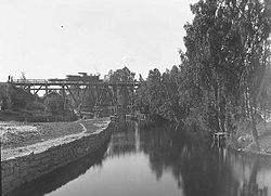 A quiet section of the river | |
| Etymology | named after the area Sandvika |
| Location | |
| Country | Norway |
| Region | Østlandet |
| Municipality | Bærum |
| Physical characteristics | |
| Source | |
| • location | Bærum, Norway |
| Source confluence | |
| • coordinates | 59°54′30″N 10°29′01″E / 59.908308°N 10.483489°E |
| Mouth | Kadettangen |
• location | Sandvika, Akershus, Norway |
• coordinates | 59°53′18″N 10°31′38″E / 59.8882479°N 10.5272198°ECoordinates: 59°53′18″N 10°31′38″E / 59.8882479°N 10.5272198°E |
• elevation | 0 m (0 ft) |
| Length | 4.5 km (2.8 mi) |
| Basin features | |
| River system | |
| Tributaries | |
| • left | Lomma |
| • right | |


Sandvikselva, formerly known as Løxa, is a river in Bærum, Norway, originating at the intersection of the two rivers Lomma and at . The river flows into the Oslo Fjord 4.5 km south at Sandvika, though the center of the city. At the mouth there are three bridges over the river.
There were formerly water mills for industry along the line, including at for . The river regularly floods, and landslides have occurred. There is a measuring station for water levels and pollution at Bjøregårdsvingen.
Sandvikselva is the premier trout river of the Oslo Fjord, and a community of dedicated volunteers invest much time and energy to preserve the conditions for the fish to be able to travel up the river to spawn each autumn.
This Viken location article is a stub. You can help Wikipedia by . |
- Rivers of Bærum
- Viken (county) geography stubs