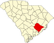
Sangaree, South Carolina
Sangaree, South Carolina | |
|---|---|
 Sangaree | |
| Coordinates: 33°02′08″N 80°07′40″W / 33.03556°N 80.12778°WCoordinates: 33°02′08″N 80°07′40″W / 33.03556°N 80.12778°W | |
| Country | United States |
| State | South Carolina |
| County | Berkeley |
| Area | |
| • Total | 2.031 sq mi (5.26 km2) |
| • Land | 2.031 sq mi (5.26 km2) |
| • Water | 0 sq mi (0 km2) |
| Elevation | 72 ft (22 m) |
| Population | |
| • Total | 8,220 |
| • Density | 4,000/sq mi (1,600/km2) |
| Time zone | UTC-5 (Eastern (EST)) |
| • Summer (DST) | UTC-4 (EDT) |
| Area code(s) | 843, 854 |
| GNIS feature ID | 1234619[3] |
Sangaree is a census-designated place and unincorporated community in Berkeley County, South Carolina, United States. Its population was 8,220 as of the 2010 census.[2]
Sangaree has a public library, a branch of the Berkeley County Library System.[4]
Demographics[]
2020 census[]
| Race | Num. | Perc. |
|---|---|---|
| White (non-Hispanic) | 4,733 | 60.83% |
| Black or African American (non-Hispanic) | 1,714 | 22.03% |
| Native American | 45 | 0.58% |
| Asian | 86 | 1.11% |
| Pacific Islander | 4 | 0.05% |
| Other/Mixed | 476 | 6.12% |
| Hispanic or Latino | 723 | 9.29% |
As of the 2020 United States census, there were 7,781 people, 2,836 households, and 2,148 families residing in the CDP.
References[]
- ^ "US Gazetteer files: 2010, 2000, and 1990". United States Census Bureau. 2011-02-12. Retrieved 2011-04-23.
- ^ a b "U.S. Census website". United States Census Bureau. Retrieved 2011-05-14.
- ^ "Sangaree". Geographic Names Information System. United States Geological Survey.
- ^ "South Carolina libraries and archives". SCIWAY. Retrieved 7 June 2019.
- ^ "Explore Census Data". data.census.gov. Retrieved 2021-12-15.
Categories:
- Census-designated places in South Carolina
- Unincorporated communities in South Carolina
- Census-designated places in Berkeley County, South Carolina
- Unincorporated communities in Berkeley County, South Carolina
- South Carolina geography stubs


