Sault Ste. Marie Water Aerodrome
Sault Ste. Marie Water Aerodrome | |||||||||||
|---|---|---|---|---|---|---|---|---|---|---|---|
 | |||||||||||
| Summary | |||||||||||
| Airport type | Public | ||||||||||
| Operator | Canadian Bushplane Heritage Centre | ||||||||||
| Location | Sault Ste. Marie, Ontario | ||||||||||
| Time zone | EST (UTC−05:00) | ||||||||||
| • Summer (DST) | EDT (UTC−04:00) | ||||||||||
| Elevation AMSL | 580 ft / 177 m | ||||||||||
| Coordinates | 46°30′16″N 084°19′24″W��� / 46.50444°N 84.32333°WCoordinates: 46°30′16″N 084°19′24″W / 46.50444°N 84.32333°W | ||||||||||
| Website | www.bushplane.com/fly-in-information | ||||||||||
| Map | |||||||||||
 CPX8 Location in Ontario | |||||||||||
| Runways | |||||||||||
| |||||||||||
Source: Water Aerodrome Supplement[1] | |||||||||||


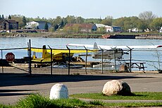
Sault Ste. Marie Water Aerodrome (TC LID: CPX8) is located adjacent on the St. Marys River in Sault Ste. Marie, Ontario, Canada. It shares its airspace and waterway with neighbouring (FAA LID: MI8) in the United States.
Sault Ste Marie Water Aerodrome services the Canadian Bushplane Heritage Centre, a museum which features many interactive bush plane, forestry, and aerial firefighting exhibits. Several aircraft are also under restoration at the centre, notably a De Havilland Fox Moth with the registration C-FBNI.[2]
See also[]
- List of airports in the Sault Ste. Marie, Ontario area
 Media related to Sault Ste. Marie Water Aerodrome at Wikimedia Commons
References[]
- ^ Nav Canada's Water Aerodrome Supplement. Effective 0901Z 26 March 2020 to 0901Z 22 April 2021.
- ^ "Sault man looks forward to getting Fox Moth airborne (6 photos)". SooToday.com. Retrieved 2018-03-05.
| By name | |
|---|---|
| By location indicator | |
| By province/territory | |
| By area | |
| National Airports System | |
| Related | |
| |
This article about an airport in Ontario is a stub. You can help Wikipedia by . |
Categories:
- Transport in Sault Ste. Marie, Ontario
- Registered aerodromes in Algoma District
- Seaplane bases in Ontario
- Binational airports
- Ontario airport stubs