Schiberg
| Schiberg | |
|---|---|
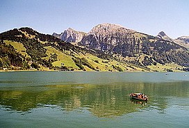
 The Schiberg (centre right) from the Wägitalersee | |
| Highest point | |
| Elevation | 2,044 m (6,706 ft) |
| Prominence | 144 m (472 ft)[1] |
| Parent peak | Brünnelistock |
| Coordinates | 47°05′33″N 8°57′13″E / 47.09250°N 8.95361°ECoordinates: 47°05′33″N 8°57′13″E / 47.09250°N 8.95361°E |
| Geography | |
 Schiberg Location in Switzerland | |
| Location | Schwyz/Glarus, Switzerland |
| Parent range | Schwyz Alps |
The Schiberg (2,044 m) is a mountain of the Schwyz Alps, located on the border between the Swiss cantons of Schwyz and Glarus. It overlooks the Wägitalersee on its west side.
References[]
- ^ Retrieved from the Swisstopo topographic maps and Google Earth. The key col is located east of the summit at 1,900 metres.
External links[]
Categories:
- Mountains of the Alps
- Mountains of Switzerland
- Mountains of the canton of Schwyz
- Mountains of the canton of Glarus
- Glarus–Schwyz border
- Switzerland geography stubs
