Schuman railway station
Brussels-Schuman | ||||||||||||||||
|---|---|---|---|---|---|---|---|---|---|---|---|---|---|---|---|---|
 Old station platform, now replaced by an expanded station. | ||||||||||||||||
| Location | Rue de la Loi/Wetstraat | |||||||||||||||
| Coordinates | 50°50′34″N 4°22′54″E / 50.84278°N 4.38167°ECoordinates: 50°50′34″N 4°22′54″E / 50.84278°N 4.38167°E | |||||||||||||||
| Owned by | National Railway Company of Belgium | |||||||||||||||
| Other information | ||||||||||||||||
| Station code | BXLS | |||||||||||||||
| History | ||||||||||||||||
| Opened | 17 December 1969 | |||||||||||||||
| Services | ||||||||||||||||
| ||||||||||||||||
Schuman is a railway and metro station in the City of Brussels located above the Schuman metro station. The station serves the European quarter of Brussels.
Rail[]
The rail station (called Brussel-Schuman/Bruxelles-Schuman) is an elevated station, though its northeastern end is "underground" as it enters a hillside. Its ticket office is located immediately next to the metro station; at one end of the railway station platforms, a stairway leads down to the Chaussée d'Etterbeek, coming out close to Maelbeek/Maalbeek metro station. Trains travelling between Brussels South station and Namur and Luxembourg call at the station. The NMBS/SNCB code for the station is FBSM.
A new tunnel was opened in April 2016 between Brussels-Schuman and Meiser, providing direct connections to Brussels National Airport and stations on the East ring line of Brussels.
Train services[]
The station is served by the following service(s):
- Intercity services (IC-16) Brussels - Namur - Arlon - Luxembourg
- Intercity services (IC-17) Brussels Airport - Brussels-Luxembourg - Namur - Dinant (weekdays)
- Intercity services (IC-17) Brussels - Namur - Dinant (weekends)
- Intercity services (IC-18) Brussels - Namur - Liege (weekdays)
- Intercity services (IC-27) Brussels Airport - Brussels-Luxembourg - Nivelles - Charleroi (weekdays)
- Brussels RER services (S4) Aalst - Denderleeuw - Brussels-Luxembourg (- Etterbeek - Merode - Vilvoorde) (weekdays)
- Brussels RER services (S5) Mechelen - Brussels-Luxembourg - Etterbeek - Halle - Enghien (- Geraardsbergen) (weekdays)
- Brussels RER services (S8) Brussels - Etterbeek - Ottignies - Louvain-la-Neuve
- Brussels RER services (S9) Leuven - Brussels-Luxembourg - Etterbeek - Braine-l'Alleud (weekdays, peak hours only)
- Brussels RER services (S81) Schaarbeek - Brussels-Luxembourg - Etterbeek - Ottignies (weekdays, peak hours only)
History[]
The original railway line through the station site ran between Brussels-Luxembourg and Brussels North and was opened on 23 October 1856, though no station was provided. In about 1865, the Grande Compagnie du Luxembourg received subsidies from the state to open stations on the line, by that point surrounded by rapid housing development, and opened a halt called Bruxelles (Rue de la Loi), on a site now occupied by part of the Berlaymont. The station was closed in about 1920.
The site was identified as a future rail and metro connection during the planning and construction of the Berlaymont and Charlemagne buildings, and opened for rail and pre-metro (underground tram) services on 17 December 1969. The pre-metro trams were replaced by the new Brussels metro on 20 September 1976.
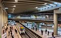
From 2008 to 2016 the station (and the metro station) underwent major renovation works, increasing the station's capacity by 2 extra tracks. These connect to a tunnel to the old Schaerbeek-Josaphat station (and marshalling yard) on line 26, in order to offer direct quick connections to Antwerp, Leuven and Brussels Airport.[1] With this third connection, the station has become one of Brussels' largest. Its new glass roof allows more daylight into the station.

Above ground works, winter 2011. Major above ground work not yet begun. The Europa building is under construction in background.

Looking into the new tunnel Jan 2015. Track has now been laid
Oct. 2015: Test train on new track crossing the metro hall


Area[]
This station is in the centre of the European quarter of Brussels, being adjacent to the Berlaymont building (headquarters of the European Commission), the Justus Lipsius building (Council of the European Union) and numerous other EU offices. The station is named after the area around the Schuman roundabout, which was itself named after Robert Schuman. The station sits on the Rue de la Loi/Wetstraat, a major city thoroughfare, and is close to Parc du Cinquantenaire/Jubelpark.
References[]
- ^ "Le tunnel Schuman-Josaphat Un chantier près de chez vous" (PDF). Info Riverains. Infrabel. 2009. Archived from the original (PDF) on 14 November 2013. Retrieved 13 November 2013.
External links[]
![]() Media related to Schuman station, Brussels at Wikimedia Commons
Media related to Schuman station, Brussels at Wikimedia Commons
- Railway stations in Brussels
- European quarter of Brussels
- Railway stations opened in 1969
- City of Brussels