Segundo Frente
Segundo Frente | |
|---|---|
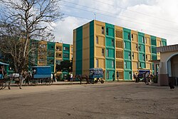 Apartment buildings in Mayarí Arriba | |
 Segundo Frente municipality (red) within Santiago Province (yellow) and Cuba | |
| Coordinates: 20°24′43″N 75°31′43″W / 20.41194°N 75.52861°WCoordinates: 20°24′43″N 75°31′43″W / 20.41194°N 75.52861°W | |
| Country | Cuba |
| Province | Santiago de Cuba |
| Seat | Mayarí Arriba |
| Area | |
| • Total | 540.2 km2 (208.6 sq mi) |
| Elevation | 180 m (590 ft) |
| Population (2005)[1] | |
| • Total | 40,885 |
| • Density | 75.7/km2 (196/sq mi) |
| Time zone | UTC-5 (EST) |
| Area code(s) | +53-226 |

Segundo Frente[1][2] (Spanish for "Second Front") is a municipality in the Santiago de Cuba Province of Cuba. Located in the northern part of the province, it is centered on the town, and municipal seat, of Mayarí Arriba.
Geography[]
The municipality is located north of the province, neighboring the provinces of Holguín and Guantánamo; and is partly included into Sierra Cristal National Park's territory. It borders with the municipalities of Mayarí, Frank País, Sagua de Tánamo, El Salvador, Songo-La Maya and San Luis.
It includes the town of Mayarí Arriba and the villages of Boca de Micara, Loma Blanca, Sabanilla, San Benito de Mayarí, Soledad and Tumba Siete.[3]
Demographics[]
In 2004, the municipality of Segundo Frente had a population of 40,885.[1] With a total area of 540 km2 (210 sq mi), it has a population density of 75.7/km2 (196/sq mi).
See also[]
References[]
- ^ a b c Santiago.cu (2006). "Municipalities of Santiago de Cuba" (in Spanish). Archived from the original on 2007-12-15. Retrieved 2007-10-05.
- ^ (in Spanish) Segundo Frente (article on EcuRed)
- ^ 5919054 Segundo Frente on OpenStreetMap
External links[]
![]() Media related to Segundo Frente at Wikimedia Commons
Media related to Segundo Frente at Wikimedia Commons
- (in Spanish) Segundo Frente on EcuRed
Places adjacent to Segundo Frente | ||||||||||||||||
|---|---|---|---|---|---|---|---|---|---|---|---|---|---|---|---|---|
| ||||||||||||||||
This Cuban location article is a stub. You can help Wikipedia by . |
- Populated places in Santiago de Cuba Province
- Cuba geography stubs