Serein
| Serein | |
|---|---|
 The Serein at Chablis | |
 | |
| Location | |
| Country | France |
| Physical characteristics | |
| Source | |
| • location | Burgundy |
| Mouth | |
• location | Yonne |
• coordinates | 47°55′21″N 3°31′30″E / 47.92250°N 3.52500°ECoordinates: 47°55′21″N 3°31′30″E / 47.92250°N 3.52500°E |
| Length | 188 km (117 mi) |
| Basin size | 1,120 km2 (430 sq mi) |
| Basin features | |
| Progression | Yonne→ Seine→ English Channel |

The Serein (French pronunciation: [səʁɛ̃] (![]() listen)) is a river of eastern France. It is the main waterway of the Chablis wine district in Burgundy. It is 188 km (117 mi) long.[1] The Serein is not navigable.
listen)) is a river of eastern France. It is the main waterway of the Chablis wine district in Burgundy. It is 188 km (117 mi) long.[1] The Serein is not navigable.
Origin of the name[]
Serein is the French word for "serene". This may reflect the placid nature of its course, or the strong monastic tradition in the area.
Geography[]
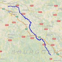
The Serein rises in the Auxois hills at Arconcey and flows north-north-west into the Yonne at Bassou. Both the A6 Autoroute du Soleil and the Paris-Lyon railway line follow a similar route through the area.
Main tributaries of the Serein and their length[]
The Serein has the following tributaries over 10 km length:[1]
- (L) - 14 km
- (L) - 13 km
- (L) - 26 km
- (R) - 10 km
- (L) - 16 km
note: R=Right L=Left
Départements and towns crossed[]
From source to mouth:
- Côte-d'Or: Arconcey, La Motte-Ternant, Époisses
- Yonne: Montréal, L'Isle-sur-Serein, Noyers, Chablis, Pontigny Abbey, Bassou
History[]
The history of the area is dominated by the Church at Pontigny and nearby Auxerre, whose remit extended to building the famous castle at Noyers.
See also[]
References[]
External links[]
| Wikimedia Commons has media related to Serein. |
- Tributaries of the Yonne
- Rivers of France
- Rivers of Yonne
- Rivers of Bourgogne-Franche-Comté