Serengeti National Park
hideThis article has multiple issues. Please help or discuss these issues on the talk page. (Learn how and when to remove these template messages)
|
| Serengeti National Park | |
|---|---|
| Swahili: Hifadhi ya Serengeti | |
 Landscape in Serengeti National Park | |
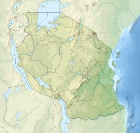 | |
| Location | Tanzania |
| Coordinates | 2°20′S 34°34′E / 2.333°S 34.567°ECoordinates: 2°20′S 34°34′E / 2.333°S 34.567°E |
| Area | 14,763 km2 (5,700 sq mi) |
| Established | 1951 |
| Visitors | 350,000 per year |
| Governing body | Tanzania National Parks Authority |
| Type | Natural |
| Criteria | vii, x |
| Designated | 1981 (5th session) |
| Reference no. | 156 |
| State Party | Tanzania |
| Region | Africa |

The Serengeti National Park is a national park in Tanzania that stretches over 14,763 km2 (5,700 sq mi). It is located in the Mara and Simiyu regions and contains 15,000,000 hectares (37,000,000 acres) of savanna. It is well known for the largest annual animal migration in the world of over 1.5 million blue wildebeest and 250,000 zebra and the largest lion population in Africa. It is under threat from deforestation, population growth and ranching.
Etymology[]
The name "Serengeti" is an approximation of the word siringet used by the Maasai people for the area, which means "the place where the land runs on forever".[1][2]
History[]
In 1930, an area of 2,286 square kilometres (883 sq mi) was designated as a game reserve in southern and eastern Serengeti.[3] In the 1930s, the government of Tanganyika established a system of national parks compliant with the Convention Relative to the Preservation of Fauna and Flora in their Natural State.[citation needed] The area became a national park in 1940. It was granted strict protection in 1948 when the Serengeti National Park Board of Trustees was formed to administer the national park. The government restricted the movements of the resident Maasai people, and the park boundaries were finalized in 1951.[4] In 1959, an area of 8,300 km2 (3,200 sq mi) was split off in the eastern part of the national park and re-established as Ngorongoro Conservation Area intended to accommodate the traditional land use interests of the Maasai people in a multiple land use area.[5] In 1981, the Serengeti National Park covered 12,950 km2 (5,000 sq mi), which was less than half of the Serengeti.[6]
The Serengeti gained fame after Bernhard Grzimek and his son Michael produced a book and film.[7]
Wildlife[]


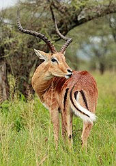
The Serengeti is thought to hold the largest lion population in Africa due in part to the abundance of prey species.[citation needed] More than 3,000 lions live in this ecosystem.[8] The park is a protected area since 2005 together with the Maasai Mara National Reserve.[9][10] The population density of the African leopard is estimated at 5.41 individuals per 100 km2 (39 sq mi) in the dry season.[11] Other mammal carnivores include the cheetah,[12] which is widely seen due to the abundance of gazelle, about 3,500 spotted hyena,[12] two species of jackal, African golden wolf, honey badger, striped hyena, caracal, serval, seven species of mongooses, two species of otters. The East African wild dog was reintroduced in 2012 after disappearing in 1991.[13]
The African bush elephant herds recovered from a population low in the 1980s caused by poaching, and numbered over 5,000 individuals by 2014.[14] The African buffalo population declined between 1976 and 1996 due to poaching, but increased to 28,524 individuals by 2008.[15] The black rhinoceros population was reduced to about 10 individuals in the 1980s due to poaching. Less than 50 individuals survive today, mainly in areas that are less likely to be affected by wildfires. Rhinos mostly browse on grasses, woody Indigofera, Acacia and Crotalaria forbs and shrubs.[16] Other mammals include aardvark, aardwolf, african wildcat, african civet, common genet, zorilla, african striped weasel, bat-eared fox, ground pangolin, crested porcupine, three species of hyraxes and cape hare.[10] Primates such as yellow and olive baboons, patas monkeys, and vervet monkey, black-and-white colobus are also seen in the gallery forests of the Grumeti River.[10]
Reptiles include Nile crocodile, leopard tortoise, serrated hinged terrapin, rainbow agama, Nile monitor, chameleon, African python, black mamba,[17] black-necked spitting cobra, and puff adder.[citation needed]
More than 500 bird species can be seen such as,[17] Masai ostrich, secretarybird, kori bustards, helmeted guineafowls, Grey-breasted spurfowl, blacksmith lapwing, african collared dove, red-billed buffalo weaver, southern ground hornbill, crowned cranes, sacred ibis, cattle egrets, black herons, knob-billed ducks, saddle-billed storks, white stork, goliath herons, marabou storks, yellow-billed stork, spotted thick-knees, lesser flamingo, shoebills, abdim's stork, hamerkops, hadada ibis, african fish eagles, pink-backed pelicans, tanzanian red-billed hornbill, martial eagles, egyptian geese, lovebirds, spur-winged geese, oxpeckers, and many species of vultures.[18][19]

A cheetah in the Serengeti prairies

A superb starling in the Serengeti National Park

Grey crowned crane in Serengeti National Park


Great migration[]
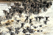

The great migration is the world's longest overland migration.[20] The complete migration is 800 km (500 mi). Roughly 1.5 million wildebeest migrate north from the south into Maasai Mara. Half a million wildebeests are born between January and March. In March, the herds leave the southern plains and start migrating. Common eland, plains zebra, and Thomson's gazelle join the wildebeest.[20] In April and May, they pass through the Western Corridor. At the beginning of the dry season, the herd moves north to the Maasai Mara to find greener grass. To get to the Maasai Mara, the herds cross the Grumeti and Mara Rivers and 3,000 crocodiles. For every wildebeest captured by the crocodiles, 50 drown.[20] When the dry season ends in late October, they[who?] head back south. Around 250,000 wildebeest and 30,000 plains zebras annually die from drowning, predation, exhaustion, thirst, or disease.[20]
Geology[]

The basement complex consists of Archaen Nyanzian System greenstones (2.81–2.63 Ga in age), Archaean granite-gneiss plutons (2.72–2.56 Ga in age), which were uplifted 180 Ma ago) forming koppies and elongated hills, the Neoproterozoic Mozambique Belt consisting of quartzite and granite, and the Neoproterozoic Ikorongo Group, consisting of sandstone, shale and siltstone that form linear ridges. The southeast portion of the park contains Neogene-aged volcanic rock and Oldoinyo Lengai Holocene-aged volcanic ash. The Grometi, Mara, Mbalageti, and Orangi rivers flow westward to Lake Victoria, while the Oldupai River flows eastward into the Olbalbal Swamps.[21]
On the eastern portion of the park lies the Serengeti volcanic grasslands which is a Tropical Grassland Ecozone. The grasslands grow on deposits of volcanic ash from the Kerimasi Volcano, which erupted 150,000 years ago, and also from the Ol Doinyo Lengai volcanic eruptions, which created layers of calcareous tuff and calcitic hard-pan soil (vertisols) from rapid weathering of the natrocarbonatite lava produced by the volcanoes.[22][23][24]
Geography[]
The park covers 14,750 km2 (5,700 sq mi)[25] of grassland plains, savanna, riverine forest, and woodlands. The park lies in northwestern Tanzania, bordered to the north by the Kenyan border, where it is continuous with the Maasai Mara National Reserve. To the southeast of the park is the Ngorongoro Conservation Area, to the southwest lies Maswa Game Reserve, to the west are the Ikorongo and Grumeti Game Reserves, and to the northeast and east lies the Loliondo Game Control Area.
The Serengeti Plain is extremely varied, ranging from savannah to hilly woodlands to open grasslands. The region's geographic diversity is due to the extreme weather conditions that plague the area, particularly the potent combination of heat and wind. The diverse habitats in the region may have originated from a series of volcanoes, whose activity shaped the basic geographic features of the plain by adding mountains and craters to the landscape.[citation needed]
The Mara River, which flows through Maasai Mara National Reserve from the Kenyan highlands to Lake Victoria, is the only permanently-flowing river in the Serengeti ecosystem.[26]

The park is divided into three regions:
- Serengeti plains: The best-known feature of the Serengeti is the almost treeless grassland in the south. It has kopjes, granite formations that serve as observation posts for predators. The Volcanic Grasslands is a edaphic plant community that grows on soils derived from volcanic ash from nearby volcanos.[citation needed]
- Western corridor: The main geographic feature is the pair of rivers, Grumeti and Mbalageti. There are big groups of riverine forest and some small mountain ranges. The great migration passes through the corridor from May to July. It stretches to Lake Victoria. The area is flatter than the northern parts of the park and more densely covered with plants than the southern plains.[citation needed]
- Northern Serengeti: the landscape is dominated by open woodlands, predominantly Commiphora and hills, ranging from Seronera in the south to the Mara River on the Kenyan border. It is remote and relatively inaccessible.[citation needed]

Human habitation is forbidden in the park except for the Tanzania National Parks Authority staff, researchers and staff of the various lodges, campsites, and hotels. The main settlement is Seronera with its primary airstrip.[citation needed]
Administration and protection[]
The park is listed by the United Nations Educational, Scientific and Cultural Organization as a World Heritage Site. It is designated as a Category II protected area under the system developed by the International Union for Conservation of Nature, which means that it should be managed to protect the ecosystem or ecological processes.[27]
The administrative body for all parks in Tanzania is the Tanzania National Parks Authority. Myles Turner was one of the park's first game wardens and is credited with bringing its rampant poaching under control.[28]
Threats[]
Deforestation in the Mau Forest region has changed the hydrology of the Mara River.[29] There are invasive species of plants such as Siam weed, Prickly pear, Feverfew and Mexican sunflower.[30] The human population of the western side of the park is growing at four percent.[when?] Livestock use is also growing which increased the amount of land turned over to farming and ranching. Roughly 200,000 animals are killed by poaching every year.[19][when?]
References[]
- ^ Poole, R. M. (2012). "Heartbreak on the Serengeti (continued)". National Geographic Magazine. Archived from the original on 29 June 2012. Retrieved 26 September 2019.
- ^ "Serengeti National Park – Kalama Safaris". Retrieved 3 August 2021.
- ^ "Serengeti National Park travel information - Tanzania". serengeti.com. Retrieved 3 August 2021.
- ^ Neumann, R.P. (1995). "Ways of seeing Africa: colonial recasting of African society and landscape in Serengeti National Park". Ecumene. 2 (2): 149–169. doi:10.1177/147447409500200203. S2CID 145421779.
- ^ Wanitzek, U. & Sippel, H. (1998). "Land rights in conservation areas in Tanzania". GeoJournal. 46 (2): 113–128. doi:10.1023/A:1006953325298. S2CID 150734077.
- ^ Makacha, S.; Msingwa, M.J. & Frame, G.W. (1982). "Threats to the Serengeti herds". Oryx. 16 (5): 437–444. doi:10.1017/S0030605300018111.
- ^ Boes, T. (2013). "Political animals: Serengeti Shall Not Die and the cultural heritage of mankind". German Studies Review. 36 (1): 41–59. JSTOR 43555291.
- ^ Mésochina, P.; Mbangwa, O.; Chardonnet, P.; Mosha, R.; Mtui, B.; Drouet, N. & Kissui, B. (2010). Conservation status of the lion (Panthera leo Linnaeus, 1758) in Tanzania (Report). Paris: SCI Foundation, MNRT-WD, TAWISA & IGF Foundation.
- ^ IUCN Cat Specialist Group (2006). Conservation Strategy for the Lion Panthera leo in Eastern and Southern Africa. Pretoria, South Africa: IUCN.
- ^ Jump up to: a b c Kennedy, Adam Scott (2014). Animals of the Serengeti, and Ngorongoro Conservation Area. Vicki Kennedy. Princeton, New Jersey. ISBN 978-1-4008-5138-6. OCLC 873760148.
- ^ Allen, M.L.; Wang, S.; Olson, L.O.; Li, Q. & Krofel, M. (2020). "Counting cats for conservation: seasonal estimates of leopard density and drivers of distribution in the Serengeti". Biodiversity and Conservation. 29 (13): 3591–3608. doi:10.1007/s10531-020-02039-w. S2CID 221167378.
- ^ Jump up to: a b "Tanzania: Concern As Serengeti Leopards Resort to Cannibalism". allafrica. Retrieved 23 July 2019.
- ^ "Why did Serengeti's wild dogs disappear? Study challenges controversial hypothesis". Mongabay Environmental News. 1 March 2019. Retrieved 28 May 2021.
- ^ Mduma, H.; Musyoki, C.; Maliti Kyale, D.; Nindi, S.; Hamza, K.; Ndetei, R.; Machoke, M.; Kimutai, D.; Muteti, D.; Maloba, M.; Bakari, S. & Kohi, E. (2014). Aerial Total Count of Elephants and Buffaloes in the Serengeti-Mara Ecosystem (PDF) (Report). Nairobi, Kenya: WWF-World Wide Fund For Nature. Archived from the original (PDF) on 9 September 2016.
- ^ Metzger, K.L.; Sinclair, A.R.E.; Hilborn, R.; Hopcraft, J.G.C. & Mduma, S.A. (2010). "Evaluating the protection of wildlife in parks: the case of African buffalo in Serengeti". Biodiversity and Conservation. 19 (12): 3431–3444. doi:10.1007/s10531-010-9904-z.
- ^ Anderson, T.M.; Ngoti, P.M.; Nzunda, M.L.; Griffith, D.M.; Speed, J.D.; Fossøy, F.; Røskaft, E. & Graae, B.J. (2020). "The burning question: does fire affect habitat selection and forage preference of the black rhinoceros Diceros bicornis in East African savannahs?". Oryx. 54 (2): 234–243. doi:10.1017/S0030605318000388.
- ^ Jump up to: a b "What Birds To Watch in Serengeti National Park". Animal Network. Retrieved 13 August 2019.
- ^ "Bird Checklist for Serengeti National Park". www.exoticbirding.com. Retrieved 28 May 2021.
- ^ Jump up to: a b "Eastern Africa: the Greater Serengeti grassland ecosystem in northern Tanzania | Ecoregions | WWF". World Wildlife Fund. Retrieved 7 June 2021.
- ^ Jump up to: a b c d Medina, N. (2019). Where Is the Serengeti?. WhoHQ. New York: Penguin Random House. ISBN 9781524792565.
- ^ Scoon, Roger (2018). Geology of National Parks of Central/ Southern Kenya and Northern Tanzania: Geotourism of the Gregory Rift Valley, Active Volcanism and Regional Plateaus. Springer. pp. 69–79. ISBN 9783319737843.
- ^ "Global Volcanism Program | Ol Doinyo Lengai". Smithsonian Institution | Global Volcanism Program. Retrieved 25 May 2021.
- ^ "Hawaiian Volcano Observatory". volcanoes.usgs.gov. Retrieved 25 June 2021.
- ^ Kindt, R., Lillesø, J.-P. B., van Breugel, P., Bingham, M., Sebsebe Demissew, Dudley, C., Friis, I., Gachathi, F., Kalema, J., Mbago, F., Minani, V., Moshi, H. N., Mulumba, J., Namaganda, M., Ndangalasi, H.J., Ruffo, C.K., Jamnadass, R. and Graudal, L. 2011. Potential natural vegetation of eastern Africa. Volume 5: Description and tree species composition for other potential natural vegetation types. Forest & Landscape Working Paper 65-2011
- ^ World Database on Protected Areas (2021). "Serengeti National Park". Protected Planet, United Nations Environment World Conservation Monitoring Centre. Retrieved 24 May 2021.
- ^ "Geology of Serengeti National Park - Tanzania". serengeti.com. Retrieved 14 July 2021.
- ^ "Category II: National Park". International Union for the Conservation of Nature. 5 February 2016. Retrieved 18 June 2020.
- ^ "Serengeti – Myles Turner". Retrieved 22 October 2016.
- ^ Conniff, R. (2015). "A New Threat in the Serengeti to the World's Greatest Animal Migration". Take Part. Retrieved 23 May 2021.
- ^ "Conservation". Grumeti Fund. Retrieved 26 May 2021.

| show Authority control |
|---|
- IUCN Category II
- 1951 establishments in Tanganyika
- Biosphere reserves of Tanzania
- Geography of Mara Region
- National parks of Tanzania
- Protected areas established in 1951
- Serengeti volcanic grasslands
- Simiyu Region
- Southern Acacia-Commiphora bushlands and thickets
- Tourist attractions in the Mara Region
- World Heritage Sites in Tanzania