Serra do Navio
Serra do Navio | |
|---|---|
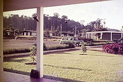
 Serra do Navio (1965) | |
 Flag  Coat of arms | |
 Location in Amapá state | |
 Serra do Navio Location in Brazil | |
| Coordinates: 0°53′45″N 52°0′7″W / 0.89583°N 52.00194°WCoordinates: 0°53′45″N 52°0′7″W / 0.89583°N 52.00194°W | |
| Country | Brazil |
| Region | North |
| State | Amapá |
| Government | |
| • Mayor | Elson Belo Lobato (AVANTE) |
| Area | |
| • Total | 7,713 km2 (2,978 sq mi) |
| Population (2020) | |
| • Total | 5,488 |
| • Density | 0.71/km2 (1.8/sq mi) |
| Time zone | UTC−3 (BRT) |
Serra do Navio (Portuguese pronunciation: [ˈsɛʁɐ du naˈviw]), (Mountain range of the Ship) is a municipality located in the center of the state of Amapá in Brazil. Its population is 5,488 (2020 est.)[1] and its area is 7,713 km².[2] In the 1947, Manganese was discovered in the area.[3] Serra do Navio[4] was built as a planned city to house the workers.[3] On 22 June 1993, the capital of the municipality was changed from Água Branca do Amapari to Serra do Novio.[4][5]
History[]
In the 1947, Manganese was discovered in the area. ICOMI was given the concession to exploit the mines, however the scale of the operation was such, that Bethlehem Steel Company was given a 49% stake in 1950. The Amapá Railway, and two towns for the workers were constructed: Serra do Navio and Vila Amazonas near Santana where a harbour was built.[3] Serra do Navio was built according to North-American standards and was considered a model town.[6]
During the 1980s, the mine produced about 1,000,000 tons of ore,[7] however Bethlehem Steel wanted to end the cooperation, because the deposits were being exhausted. The contract was originally set to end in 2003, however in 1996, Bethlehem Steel decided to end the contract.[3]

The closing of the main mine, led to a steep decrease in population, and the appearance of a ghost town. Smaller mines still operate in the region. Other economic activities include agriculture, and forestry.[6]
Serra do Navio is located on the BR-210 highway.[6] The municipality is subdivided in two districts: The town of Serra do Navio and Cachaço.[8]
Nature[]
The municipality contains 7.83% of the 2,369,400 hectares (5,855,000 acres) Amapá State Forest, a sustainable use conservation unit established in 2006.[9]
Notable people[]
- Fernanda Takai (1975), singer and guitarist[10]
Climate[]
| hideClimate data for Serra do Navio (1981–2010) | |||||||||||||
|---|---|---|---|---|---|---|---|---|---|---|---|---|---|
| Month | Jan | Feb | Mar | Apr | May | Jun | Jul | Aug | Sep | Oct | Nov | Dec | Year |
| Average high °C (°F) | 29.9 (85.8) |
29.5 (85.1) |
30.0 (86.0) |
30.1 (86.2) |
29.8 (85.6) |
30.2 (86.4) |
30.8 (87.4) |
31.4 (88.5) |
32.2 (90.0) |
32.5 (90.5) |
32.1 (89.8) |
30.8 (87.4) |
30.8 (87.4) |
| Average low °C (°F) | 21.3 (70.3) |
21.7 (71.1) |
21.6 (70.9) |
21.6 (70.9) |
21.8 (71.2) |
21.4 (70.5) |
21.1 (70.0) |
21.4 (70.5) |
21.6 (70.9) |
21.6 (70.9) |
21.4 (70.5) |
21.7 (71.1) |
21.5 (70.7) |
| Average precipitation mm (inches) | 238.4 (9.39) |
311.2 (12.25) |
304.6 (11.99) |
273.0 (10.75) |
282.5 (11.12) |
206.0 (8.11) |
168.1 (6.62) |
135.1 (5.32) |
81.6 (3.21) |
78.6 (3.09) |
96.4 (3.80) |
167.3 (6.59) |
2,342.8 (92.24) |
| Average precipitation days (≥ 1.0 mm) | 22 | 21 | 22 | 22 | 24 | 20 | 18 | 15 | 10 | 9 | 11 | 17 | 211 |
| Mean monthly sunshine hours | 113.2 | 92.7 | 96.2 | 97.7 | 121.3 | 144.0 | 185.9 | 211.7 | 221.0 | 234.7 | 194.3 | 151.7 | 1,864.4 |
| Source: Instituto Nacional de Meteorologia[11] | |||||||||||||
References[]
- ^ IBGE 2020
- ^ "IBGE | Cidades | Amapá | Serra do Navio". cidades.ibge.gov.br. Retrieved 2016-05-17.
- ^ Jump up to: a b c d "Exploração de manganês pela ICOMI: passivo ambiental para a população de Serra do Navio". Conflictos Mineros (in Portuguese). Retrieved 3 April 2021.
- ^ Jump up to: a b "Serra do Navio". IBGE (in Portuguese). Retrieved 3 April 2021.
- ^ ""Podemos nunca mais ouvir o apito do trem entrando nas matas de Serra do Navio"". Diário do Amapá (in Portuguese). Retrieved 4 April 2021.
- ^ Jump up to: a b c "Serra do Navio". Government of Amapá (in Portuguese). Retrieved 3 April 2021.
- ^ "Brazil". Mining Encyclopedia. Retrieved 3 April 2021.
- ^ "Serra do Navio". IBGE (in Portuguese). Retrieved 1 April 2021.
- ^ FES do Amapá (in Portuguese), ISA: Instituto Socioambiental, retrieved 2016-07-06
- ^ "Bio". Fernanda Takai (in Portuguese). Retrieved 2 April 2021.
- ^ "Normais Climatológicas Do Brasil 1981–2010" (in Portuguese). Instituto Nacional de Meteorologia. Retrieved 15 November 2018.
External links[]
- Official website (in Portuguese)
 Media related to Serra do Navio at Wikimedia Commons
- Manganese mines in Brazil
- Municipalities in Amapá
- Planned cities in Brazil
- Populated places in Amapá

