Serrapetrona
Serrapetrona | |
|---|---|
| Comune di Serrapetrona | |
 Panorama of Serrapetrona. | |
 Coat of arms | |
show Location of Serrapetrona | |
 Serrapetrona Location of Serrapetrona in Italy | |
| Coordinates: 43°11′N 13°11′E / 43.183°N 13.183°E | |
| Country | Italy |
| Region | Marche |
| Province | Macerata (MC) |
| Frazioni | Borgiano, Castel San Venanzo |
| Government | |
| • Mayor | Silvia Pinzi |
| Area | |
| • Total | 37.6 km2 (14.5 sq mi) |
| Elevation | 474 m (1,555 ft) |
| Population (30 June 2011)[3] | |
| • Total | 1,012 |
| • Density | 27/km2 (70/sq mi) |
| Demonym(s) | Serrapetronesi |
| Time zone | UTC+1 (CET) |
| • Summer (DST) | UTC+2 (CEST) |
| Postal code | 62020 |
| Dialing code | 0733 |
| Patron saint | St. Clement |
| Website | Official website |


Serrapetrona is a comune (municipality) in the province of Macerata in the Italian region Marche, located about 60 kilometres (37 mi) southwest of Ancona and about 25 kilometres (16 mi) southwest of Macerata.
Serrapetrona borders the following municipalities: Belforte del Chienti, Caldarola, Camerino, Castelraimondo, San Severino Marche, Tolentino.
The church of Santa Maria is located in the square Piazza Santa Maria.
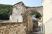
Defensive gate
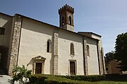
The church San Francesco
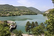
The Lake Lago di Caccamo
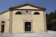
The church San Paolo in Borgiano


References[]
- ^ "Superficie di Comuni Province e Regioni italiane al 9 ottobre 2011". Istat. Retrieved 16 March 2019.
- ^ "Popolazione Residente al 1° Gennaio 2018". Istat. Retrieved 16 March 2019.
- ^ All demographics and other statistics: Italian statistical institute Istat.
| Authority control |
|---|
Categories:
- Cities and towns in the Marche
- Municipalities of the Province of Macerata
- Marche geography stubs