Shaan-Gan-Ning Border Region
This article may be expanded with text translated from the corresponding article in Chinese. (January 2022) Click [show] for important translation instructions.
|
| Shaan-Gan-Ning Border Region 陝甘寧邊區 | |||||||||
|---|---|---|---|---|---|---|---|---|---|
| Border Region of China Rump state of the Chinese Soviet Republic | |||||||||
| 1937–1950 | |||||||||
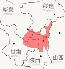 Map of Shaan-Gan-Ning Border Region. | |||||||||
| Capital | Yan'an (1937–47, 1948-49) Xi'an (1949–50) | ||||||||
| Area | |||||||||
• 1937 | 130,000 km2 (50,000 sq mi) | ||||||||
| Population | |||||||||
• 1937 | 1,500,000 | ||||||||
| History | |||||||||
| Government | |||||||||
| Chairman | |||||||||
• 1937–1948 | Lin Boqu | ||||||||
| Deputy Chairman | |||||||||
• 1937–1938 | Zhang Guotao | ||||||||
• 1938–1945 | |||||||||
| Historical era | Chinese Civil War | ||||||||
• Established | 6 September 1937 | ||||||||
• Disestablished | 19 January 1950 | ||||||||
| |||||||||
| Today part of | |||||||||
Shaan–Gan–Ning or in postal romanization Shen–Kan–Ning (traditional Chinese: 陝甘寧邊區; simplified Chinese: 陕甘宁边区; pinyin: Shǎn-Gān-Níng Biānqū) was a historical proto-state that was formed by the Chinese Communist Party following the collapse of the Chinese Soviet Republic in agreement with the Kuomintang as a part of the Second United Front policy, substituting the former anti-Kuomintang Soviets.
It was one of the two border region governments with the capital at Yan'an, named after the provinces of Shaanxi, Gansu, and Ningxia with some parts incorporated from Suiyuan province which is now part of Inner Mongolia. Later, the second region that was created was known as the (晉察冀邊區; 晋察冀边区; Jìn-Chá-Jì Biānqū). It is lesser known because the name refers to the old geographic realities, which were Shanxi, Chahar, and Hebei, respectively.
References[]
This article related to the history of China is a stub. You can help Wikipedia by . |
- States and territories established in 1937
- States and territories disestablished in 1950
- Chinese Civil War
- Chinese Communist Party
- History of Shaanxi
- Yan'an
- Chinese history stubs